
Stratford, Iowa facts for kids
Quick facts for kids
Stratford, Iowa
|
|
|---|---|

City sign
|
|
| Motto(s):
The place to be
|
|

Location of Stratford, Iowa
|
|
| Country | |
| State | |
| Counties | Hamilton, Webster |
| Area | |
| • Total | 1.81 sq mi (4.70 km2) |
| • Land | 1.81 sq mi (4.70 km2) |
| • Water | 0.00 sq mi (0.00 km2) |
| Elevation | 1,109 ft (338 m) |
| Population
(2020)
|
|
| • Total | 707 |
| • Density | 389.53/sq mi (150.39/km2) |
| Time zone | UTC-6 (Central (CST)) |
| • Summer (DST) | UTC-5 (CDT) |
| ZIP code |
50249
|
| Area code(s) | 515 |
| FIPS code | 19-75810 |
| GNIS feature ID | 0462029 |
| Website | www.stratfordiowa.com |
Stratford is a city located in the state of Iowa, USA. It's found in both Hamilton and Webster counties. In 2020, about 707 people lived there.
Contents
A Look at Stratford's History
Stratford was officially planned and laid out in 1880. It got its name from a famous place in England called Stratford-upon-Avon. A post office has been open in Stratford since 1881.
The town was first started at a spot called Hook's Point. A train line ran through Stratford from 1880 until World War II. Stratford has its own school system, with an elementary school located on Shakespeare Avenue.
On November 12, 2005, a strong tornado hit Stratford. Sadly, one person lost their life during this event.
Where is Stratford Located?
Stratford is located in the central part of the United States. Its exact position on a map can be found using coordinates. These are 42.270919 degrees North and -93.926862 degrees West.
The city covers a total area of about 1.81 square miles (4.70 square kilometers). All of this area is land, meaning there are no large lakes or rivers within the city limits.
Population and People
| Historical populations | ||
|---|---|---|
| Year | Pop. | ±% |
| 1900 | 458 | — |
| 1910 | 554 | +21.0% |
| 1920 | 694 | +25.3% |
| 1930 | 699 | +0.7% |
| 1940 | 712 | +1.9% |
| 1950 | 673 | −5.5% |
| 1960 | 703 | +4.5% |
| 1970 | 710 | +1.0% |
| 1980 | 806 | +13.5% |
| 1990 | 715 | −11.3% |
| 2000 | 746 | +4.3% |
| 2010 | 743 | −0.4% |
| 2020 | 707 | −4.8% |
| Source: and Iowa Data Center Source: |
||
Stratford's Population in 2020
In 2020, the city of Stratford had 707 residents. There were 284 households and 167 families living there. The city had about 390 people per square mile.
Most of the people living in Stratford were White (93.6%). A small number were from other racial backgrounds. About 3.7% of the population identified as Hispanic or Latino.
The average age of people in Stratford was 50.8 years old. About 18.4% of residents were under 20 years old. Many residents, 32.8%, were 65 years or older. The number of males and females in the city was almost equal.
Stratford's Population in 2010
Back in 2010, Stratford had 743 people living in the city. There were 307 households and 183 families. The population density was about 389 people per square mile.
Most of the people were White (99.2%). About 1.3% of the population was Hispanic or Latino.
The average age in 2010 was 46.3 years. About 22.2% of residents were under 18. Also, 26.9% were 65 years or older. The number of males and females was very close to even.
Images for kids
-

Stratford City Hall
-
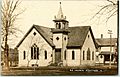
A church in Stratford seen in 1912
-

Stratford Public Library
-
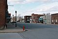
Downtown Stratford


See also
 In Spanish: Stratford (Iowa) para niños
