
Webster County, Iowa facts for kids
Quick facts for kids
Webster County
|
|
|---|---|

The courthouse in Fort Dodge is on the NRHP.
|
|

Location within the U.S. state of Iowa
|
|
 Iowa's location within the U.S. |
|
| Country | |
| State | |
| Founded | January 15, 1851 |
| Named for | Daniel Webster |
| Seat | Fort Dodge |
| Largest city | Fort Dodge |
| Area | |
| • Total | 718 sq mi (1,860 km2) |
| • Land | 716 sq mi (1,850 km2) |
| • Water | 2.8 sq mi (7 km2) 0.4% |
| Population
(2020)
|
|
| • Total | 36,999 |
| • Density | 51.53/sq mi (19.896/km2) |
| Time zone | UTC−6 (Central) |
| • Summer (DST) | UTC−5 (CDT) |
| Congressional district | 4th |
Webster County is a county located in the state of Iowa in the United States. In 2020, about 36,999 people lived here. The main city and government center is Fort Dodge.
The county was created in January 1851. It was one of 43 counties started by a group of laws passed at that time. Webster County is named after Daniel Webster. He was a famous American leader known for his great speeches. The area around Fort Dodge, including Webster County, is sometimes called the Fort Dodge, IA Micropolitan Statistical Area. This means it's a smaller city area that is important for jobs and life in the region.
Contents
Exploring Webster County's Geography
Webster County covers an area of about 718 square miles. Most of this area, about 716 square miles, is land. The rest, about 2.8 square miles, is water. That's about 0.4% of the county's total size.
Main Roads and Highways
Several important roads help people travel through Webster County. These are like the main arteries of the county, connecting different towns and areas.
 U.S. Highway 20 – This highway goes from east to west right through the middle of Webster County. It passes through towns like Moorland and Coalville.
 U.S. Highway 169 – This highway enters the northern part of the county. It runs south to Harcourt, then goes east for a few miles before turning south again to leave the county.
 Iowa Highway 7 – This road comes into western Webster County from Manson. It goes east until it meets U.S. Highway 169 in Fort Dodge.
 Iowa Highway 175 – This highway enters the southeastern part of Webster County from Stratford. It travels west and then north, connecting with U.S. Highway 169.
 Iowa Highway 144 – This road enters the southern part of the county. It goes north until it connects with Iowa Highway 175.
Public Transportation and Travel
- Dodger Area Rapid Transit – This is a local bus service that helps people get around Fort Dodge and nearby areas.
- List of intercity bus stops in Iowa – You can find places here where buses stop to take people to other cities.
Fort Dodge Regional Airport
The Fort Dodge Regional Airport (FOD) is located just north of Fort Dodge. It's mainly used for smaller, private planes. However, you can also catch daily flights from here to bigger airports like Lambert-St. Louis International Airport and Minneapolis-Saint Paul International Airport. There are also connecting flights through Mason City to Chicago O'Hare International Airport.
Neighboring Counties
Webster County shares its borders with several other counties in Iowa:
- Boone County (to the southeast)
- Calhoun County (to the west)
- Greene County (to the southwest)
- Hamilton County (to the east)
- Humboldt County (to the north)
- Pocahontas County (to the northwest)
- Wright County (to the northeast)
Population and People of Webster County
The number of people living in Webster County has changed over the years. Here's a look at how the population has grown and shifted.
| Historical population | |||
|---|---|---|---|
| Census | Pop. | %± | |
| 1860 | 2,504 | — | |
| 1870 | 10,484 | 318.7% | |
| 1880 | 15,951 | 52.1% | |
| 1890 | 21,582 | 35.3% | |
| 1900 | 31,757 | 47.1% | |
| 1910 | 34,629 | 9.0% | |
| 1920 | 37,611 | 8.6% | |
| 1930 | 40,425 | 7.5% | |
| 1940 | 41,521 | 2.7% | |
| 1950 | 44,241 | 6.6% | |
| 1960 | 47,810 | 8.1% | |
| 1970 | 48,391 | 1.2% | |
| 1980 | 45,953 | −5.0% | |
| 1990 | 40,342 | −12.2% | |
| 2000 | 40,235 | −0.3% | |
| 2010 | 38,013 | −5.5% | |
| 2020 | 36,999 | −2.7% | |
| 2023 (est.) | 36,485 | −4.0% | |
| U.S. Decennial Census 1790–1960 1900–1990 1990–2000 2010–2018 |
|||

What the 2020 Census Shows
The 2020 census counted 36,999 people living in Webster County. This means there are about 51 people living in each square mile. Most people (94.86%) said they belonged to one race. There were 16,937 homes in the county, and 15,046 of them were lived in.

| Race | Number of People | Percentage |
|---|---|---|
| White (not Hispanic) | 31,372 | 84.8% |
| Black or African American (not Hispanic) | 1,773 | 4.8% |
| Native American (not Hispanic) | 112 | 0.3% |
| Asian (not Hispanic) | 295 | 0.8% |
| Pacific Islander (not Hispanic) | 16 | 0.04% |
| Other/Mixed (not Hispanic) | 1,368 | 3.7% |
| Hispanic or Latino | 2,063 | 5.6% |
Population by City and Town
Here's a list of the cities and towns in Webster County, ranked by how many people lived there in 2020.
| Rank | City/Town/etc. | Type | Population (2020 Census) |
|---|---|---|---|
| 1 | † Fort Dodge | City | 24,871 |
| 2 | Gowrie | City | 952 |
| 3 | Dayton | City | 772 |
| 4 | Coalville | CDP | 651 |
| 5 | Badger | City | 522 |
| 6 | Otho | City | 429 |
| 7 | Lehigh | City | 395 |
| 8 | Duncombe | City | 381 |
| 9 | Callender | City | 368 |
| 10 | Harcourt | City | 264 |
| 11 | Barnum | City | 175 |
| 12 | Moorland | City | 168 |
| 13 | Clare | City | 136 |
| 14 | Vincent | City | 130 |
| 15 | Stratford (mostly in Hamilton County) | City | 22 (707 total) |
| 16 | Farnhamville (mostly in Calhoun County) | City | 0 (383 total) |
Communities in Webster County
Webster County has many different communities, from small towns to larger cities.
Cities
Census-Designated Place
- Coalville – This is a community that is counted in the census but isn't officially a city or town.
Unincorporated Communities
These are small places that don't have their own local government.
Townships
Townships are smaller areas within a county, often used for local administration. Webster County has many townships:
- Badger
- Burnside
- Clay
- Colfax
- Cooper
- Dayton
- Deer Creek
- Douglas
- Elkhorn
- Fulton
- Gowrie
- Hardin
- Jackson
- Johnson
- Lost Grove
- Newark
- Otho
- Pleasant Valley
- Roland
- Sumner
- Wahkonsa
- Washington
- Webster
- Yell
Notable People from Webster County
- Robert Schliske – He was born in Webster County and later became a member of the Wyoming House of Representatives from 1971 to 1975.
Images for kids
-
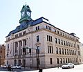
The courthouse in Fort Dodge is a historic building.
-
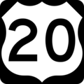
U.S. Highway 20 sign.
-
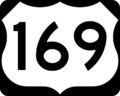
U.S. Highway 169 sign.
-

Iowa Highway 7 sign.
-

Iowa Highway 175 sign.
-

Iowa Highway 144 sign.
-

Population of Webster County from 1860 to 2010.
-
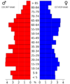
2022 US Census population pyramid for Webster County.


See also
 In Spanish: Condado de Webster (Iowa) para niños
