Harcourt, Iowa facts for kids
Quick facts for kids
Harcourt, Iowa
|
|
|---|---|

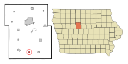
Location of Harcourt, Iowa
|
|
| Country | |
| State | |
| County | Webster |
| Area | |
| • Total | 1.01 sq mi (2.62 km2) |
| • Land | 1.01 sq mi (2.62 km2) |
| • Water | 0.00 sq mi (0.00 km2) |
| Elevation | 1,175 ft (358 m) |
| Population
(2020)
|
|
| • Total | 264 |
| • Density | 261.13/sq mi (100.81/km2) |
| Time zone | UTC-6 (Central (CST)) |
| • Summer (DST) | UTC-5 (CDT) |
| ZIP code |
50544
|
| Area code(s) | 515 |
| FIPS code | 19-34410 |
| GNIS feature ID | 0457242 |
Harcourt is a small city located in Webster County, Iowa, United States. In 2020, the city had a population of 264 people.
Contents
History of Harcourt
Harcourt was officially planned and laid out in 1881. When a town is "platted," it means its streets, blocks, and lots are drawn on a map. This helps organize how the town will grow.
The city was named after William Vernon Harcourt, who was an important British politician. A post office, where people send and receive mail, has been open in Harcourt since 1882.
Geography of Harcourt
Harcourt is located at 42°15′43″N 94°10′36″W / 42.26194°N 94.17667°W. This is its exact spot on a map.
The United States Census Bureau says that Harcourt covers a total area of about 1.00 square mile (2.6 square kilometers). All of this area is land, meaning there are no large lakes or rivers within the city limits.
Population and People
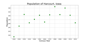
The number of people living in Harcourt has changed over the years. You can see how the population has grown and shrunk in the table and chart below.
| Historical populations | ||
|---|---|---|
| Year | Pop. | ±% |
| 1900 | 192 | — |
| 1910 | 247 | +28.6% |
| 1920 | 307 | +24.3% |
| 1930 | 264 | −14.0% |
| 1940 | 282 | +6.8% |
| 1950 | 303 | +7.4% |
| 1960 | 268 | −11.6% |
| 1970 | 305 | +13.8% |
| 1980 | 347 | +13.8% |
| 1990 | 306 | −11.8% |
| 2000 | 340 | +11.1% |
| 2010 | 303 | −10.9% |
| 2020 | 264 | −12.9% |
| Source: and Iowa Data Center Source: |
||
Population in 2020
According to the census in 2020, there were 264 people living in Harcourt. There were 120 households, which are groups of people living together in one home.
The average number of people per square mile was about 261. This tells us how crowded or spread out the population is. Most residents, about 91.7%, identified as White.
The average age of people in Harcourt was 45.3 years old. About 21.2% of the residents were under 20 years old. Also, 22.3% were 65 years old or older. The population was almost evenly split between males (49.6%) and females (50.4%).
Education in Harcourt
Students in Harcourt attend schools within the Southeast Valley Community School District. The main high school for this district is Southeast Valley High School, which is located in a nearby town called Gowrie.
Harcourt used to be part of the Southeast Webster-Grand Community School District. This district was formed in 2005 when two smaller school districts joined together. In 2023, the Southeast Webster-Grand district merged into the current Southeast Valley district.
Before that, Harcourt was served by the Southeast Webster Community School District. This district was created in 1991 from the merger of the Central Webster and Dayton school districts.
See also
 In Spanish: Harcourt (Iowa) para niños


