Callender, Iowa facts for kids
Quick facts for kids
Callender, Iowa
|
|
|---|---|

Location of Callender, Iowa
|
|
| Country | |
| State | |
| County | Webster |
| Area | |
| • Total | 0.53 sq mi (1.36 km2) |
| • Land | 0.53 sq mi (1.36 km2) |
| • Water | 0.00 sq mi (0.00 km2) |
| Elevation | 1,152 ft (351 m) |
| Population
(2020)
|
|
| • Total | 368 |
| • Density | 699.62/sq mi (270.37/km2) |
| Time zone | UTC-6 (Central (CST)) |
| • Summer (DST) | UTC-5 (CDT) |
| ZIP code |
50523
|
| Area code(s) | 515 |
| FIPS code | 19-09955 |
| GNIS feature ID | 0455056 |
Callender is a small city in Webster County, Iowa, United States. In 2020, 368 people lived there.
Contents
History of Callender
How the Railroad Helped Start the Town
Between 1866 and 1870, the Des Moines Valley Railroad Company built train tracks. These tracks connected Des Moines and Fort Dodge. Many small towns grew along this new railroad line. These towns helped with track repairs and business.
One of these stops was Kesho, which later became Callender. It was the 36th stop on the line.
Kesho: The First Name
The town of Kesho started around 1867. Gurmond and Thora Bean opened a store there. The railroad reached Kesho in December 1869.
However, in 1870, a newspaper said that the town of Kesho had almost disappeared! Buildings were moved away. A new train station was built later, but it was taken down in 1972. Kesho had a post office from 1873 to 1877.
Callender: The New Name
In 1875, the town got a new name: Callender. It was named after Agnes and James Callender. They lived in Brooklyn Heights, New York City, New York. The Callenders owned a lot of land in the area.
They gave land to the town for important places. These included churches, the school, City Hall, and the City Park. A second train station was built on the west side of the tracks. The town today still looks much like it did in 1875.
Where is Callender?
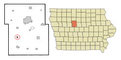
Callender is located in Iowa. It covers a total area of about 0.52 square miles (1.35 square kilometers). All of this area is land.
People in Callender
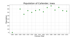
| Historical populations | ||
|---|---|---|
| Year | Pop. | ±% |
| 1880 | 50 | — |
| 1900 | 399 | +698.0% |
| 1910 | 321 | −19.5% |
| 1920 | 376 | +17.1% |
| 1930 | 349 | −7.2% |
| 1940 | 377 | +8.0% |
| 1950 | 387 | +2.7% |
| 1960 | 358 | −7.5% |
| 1970 | 421 | +17.6% |
| 1980 | 446 | +5.9% |
| 1990 | 384 | −13.9% |
| 2000 | 424 | +10.4% |
| 2010 | 376 | −11.3% |
| 2020 | 368 | −2.1% |
| Source: and Source: |
||
Population in 2020
In 2020, there were 368 people living in Callender. Most of the people (92.4%) were White. About 4.1% of the population was Hispanic or Latino.
The average age in the city was about 40.3 years old. About 26.6% of the people were under 20 years old.
Population in 2010
In 2010, Callender had 376 people. Most people (98.7%) were White.
About 23.4% of the people were under 18 years old. The average age was 42.3 years.
Education in Callender
Callender is part of the Southeast Valley Community School District. Students in high school attend Southeast Valley High School in Gowrie.
Callender used to be in the Prairie Valley Community School District. This district joined with the Southeast Valley district in 2023.
From 1994 to 2010, Callender had the elementary school for the district. Before that, Callender had both an elementary and a middle school.
Getting Around Callender
Roads and Railroads
Callender is located where County Roads P33 (Fairbanks Ave) and D43 (295th St) meet.
The Union Pacific Railroad tracks are on the east side of town.
Airport Nearby
The Fort Dodge Regional Airport is about 20 miles (32 kilometers) northwest of Callender. It is mainly used for smaller planes. However, it also has some commercial flights.
See also
 In Spanish: Callender (Iowa) para niños
 | Lonnie Johnson |
 | Granville Woods |
 | Lewis Howard Latimer |
 | James West |


