Farnhamville, Iowa facts for kids
Quick facts for kids
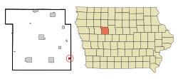
Farnhamville, Iowa
|
|
|---|---|

Location of Farnhamville, Iowa
|
|
| Country | |
| State | |
| Counties | Calhoun, Webster |
| Area | |
| • Total | 0.67 sq mi (1.72 km2) |
| • Land | 0.66 sq mi (1.71 km2) |
| • Water | 0.01 sq mi (0.02 km2) |
| Elevation | 1,142 ft (348 m) |
| Population
(2020)
|
|
| • Total | 383 |
| • Density | 581.18/sq mi (224.48/km2) |
| Time zone | UTC-6 (Central (CST)) |
| • Summer (DST) | UTC-5 (CDT) |
| ZIP code |
50538
|
| Area code(s) | 515 |
| FIPS code | 19-26940 |
| GNIS feature ID | 0456555 |
Farnhamville is a small city located in Iowa, a state in the United States. It's special because it sits across two counties: Calhoun County and Webster County. In 2020, about 383 people lived there.
Contents
History of Farnhamville
Farnhamville started as a town in 1881. It was first called Farnham, named after R. E. Farnham, who worked for the railroad. But the postal service didn't like that name. So, the town was renamed Farnhamville when its post office opened later that year. Farnhamville officially became a city in 1892.
Geography of Farnhamville
Farnhamville is located at 42°16′35″N 94°24′23″W / 42.27639°N 94.40639°W. This means it's in a specific spot on the map.
The city covers a total area of about 0.66 square miles (1.72 square kilometers). Most of this area is land. Only a tiny part, about 0.01 square miles (0.02 square kilometers), is water.
Population and People
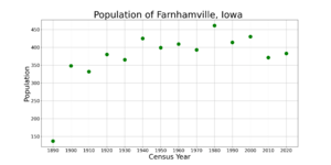
This section tells us about the number of people living in Farnhamville over time.
| Historical populations | ||
|---|---|---|
| Year | Pop. | ±% |
| 1890 | 137 | — |
| 1900 | 348 | +154.0% |
| 1910 | 332 | −4.6% |
| 1920 | 380 | +14.5% |
| 1930 | 365 | −3.9% |
| 1940 | 425 | +16.4% |
| 1950 | 399 | −6.1% |
| 1960 | 409 | +2.5% |
| 1970 | 393 | −3.9% |
| 1980 | 461 | +17.3% |
| 1990 | 414 | −10.2% |
| 2000 | 430 | +3.9% |
| 2010 | 371 | −13.7% |
| 2020 | 383 | +3.2% |
| Source: and Iowa Data Center Source: |
||
Farnhamville's Population Changes
The population of Farnhamville has changed over the years. For example, in 1890, there were 137 people. By 1900, it had grown to 348. The population reached its highest in 1980 with 461 people. In 2020, the population was 383 people.
Who Lives in Farnhamville?
In 2020, there were 383 people living in Farnhamville. These people lived in 172 households. A household is like a home where people live together.
About 27% of the households had children under 18 living with them. The average age of people in the city was about 40 years old. This means there's a mix of younger and older residents.
Education in Farnhamville
Students in Farnhamville attend schools in the Southeast Valley Community School District. This district runs several schools for different age groups.
Farnhamville Elementary School is located near, but not inside, Farnhamville. It used to be called Prairie Valley Elementary School. Older students go to Southeast Valley Middle School in Burnside. High school students attend Southeast Valley High School in Gowrie.
Before 2023, Farnhamville was part of the Prairie Valley Community School District. This district was formed in 1993. It combined two older school districts. In 2023, the Prairie Valley district joined with the Southeast Valley district.
See also
 In Spanish: Farnhamville (Iowa) para niños
 | Selma Burke |
 | Pauline Powell Burns |
 | Frederick J. Brown |
 | Robert Blackburn |


