Pocahontas County, Iowa facts for kids
Quick facts for kids
Pocahontas County
|
|
|---|---|

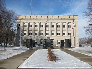
County Courthouse
|
|

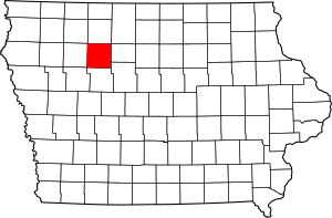
Location within the U.S. state of Iowa
|
|
 Iowa's location within the U.S. |
|
| Country | |
| State | |
| Founded | 1851 |
| Named for | Pocahontas |
| Seat | Pocahontas |
| Largest city | Pocahontas |
| Area | |
| • Total | 579 sq mi (1,500 km2) |
| • Land | 577 sq mi (1,490 km2) |
| • Water | 1.4 sq mi (4 km2) 0.2% |
| Population
(2020)
|
|
| • Total | 7,078 |
| • Density | 12.225/sq mi (4.720/km2) |
| Time zone | UTC−6 (Central) |
| • Summer (DST) | UTC−5 (CDT) |
| Congressional district | 4th |
Pocahontas County is a county located in the state of Iowa, United States. It was created in 1851. The county seat, which is like the main town where the county government is, is called Pocahontas.
As of the 2020 census, about 7,078 people lived here. This makes it one of the less populated counties in Iowa. The county is named after Pocahontas, a famous Native American woman from long ago. She was known for her connection to the early English settlers in Jamestown, Virginia. In the city of Pocahontas, there's a large statue honoring her.
Contents
Geography
Pocahontas County covers a total area of about 579 square miles. Most of this area, about 577 square miles, is land. Only a small part, about 1.4 square miles, is water. This means the county is mostly land.
Major Highways in the County
These are the main roads that go through Pocahontas County:
Counties Next to Pocahontas County
Pocahontas County shares its borders with these other counties:
- Palo Alto County (to the north)
- Humboldt County (to the east)
- Webster County (to the southeast)
- Calhoun County (to the south)
- Buena Vista County (to the west)
Population Information

The word "demographics" means information about the people who live in an area. This includes things like how many people there are, their ages, and their backgrounds.
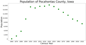
| Historical population | |||
|---|---|---|---|
| Census | Pop. | %± | |
| 1860 | 103 | — | |
| 1870 | 1,446 | 1,303.9% | |
| 1880 | 3,713 | 156.8% | |
| 1890 | 9,553 | 157.3% | |
| 1900 | 15,339 | 60.6% | |
| 1910 | 14,808 | −3.5% | |
| 1920 | 15,602 | 5.4% | |
| 1930 | 15,687 | 0.5% | |
| 1940 | 16,266 | 3.7% | |
| 1950 | 15,496 | −4.7% | |
| 1960 | 14,234 | −8.1% | |
| 1970 | 12,729 | −10.6% | |
| 1980 | 11,369 | −10.7% | |
| 1990 | 9,525 | −16.2% | |
| 2000 | 8,662 | −9.1% | |
| 2010 | 7,310 | −15.6% | |
| 2020 | 7,078 | −3.2% | |
| 2023 (est.) | 6,976 | −4.6% | |
| U.S. Decennial Census 1790-1960 1900-1990 1990-2000 2010-2018 |
|||
What the 2020 Census Showed
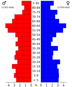
The census is a count of all the people living in a country, done every ten years. The 2020 census found that 7,078 people lived in Pocahontas County. This means there were about 12 people living in each square mile.
Most people, about 95.79%, said they belonged to one race. There were 3,666 homes in the county, and 3,090 of them were lived in.
Here's a quick look at the different groups of people in Pocahontas County in 2020:
| Race | Number of People | Percentage |
|---|---|---|
| White | 6,383 | 90.2% |
| Black or African American | 66 | 0.9% |
| Native American | 10 | 0.14% |
| Asian | 29 | 0.41% |
| Pacific Islander | 23 | 0.32% |
| Other/Mixed | 213 | 3% |
| Hispanic or Latino | 354 | 5% |
What the 2010 Census Showed
The 2010 census counted 7,310 people in Pocahontas County. The population density was about 12.6 people per square mile. At that time, there were 3,794 homes, and 3,233 of them were lived in.
Cities and Towns
Pocahontas County has several cities and smaller communities.
Cities
Unincorporated Communities
These are smaller places that are not officially cities or towns:
Townships
Townships are smaller areas within a county, often used for local government or land division.
- Bellville
- Cedar
- Center
- Colfax
- Cummins
- Des Moines
- Dover
- Garfield
- Grant
- Lake
- Lincoln
- Lizard
- Marshall
- Powhatan
- Roosevelt
- Sherman
- Swan Lake
Population Ranking of Cities
This table shows the cities in Pocahontas County, ranked by how many people lived there in the 2020 census.
† The county seat
| Rank | City/Town/etc. | Type | Population (2020 Census) |
|---|---|---|---|
| 1 | † Pocahontas | City | 1,867 |
| 2 | Laurens | City | 1,264 |
| 3 | Fonda | City | 636 |
| 4 | Rolfe | City | 509 |
| 5 | Gilmore City (partially in Humboldt County) | City | 217 (487 total) |
| 6 | Palmer | City | 138 |
| 7 | Havelock | City | 130 |
| 8 | Varina | City | 68 |
| 9 | Plover | City | 50 |
See also
 In Spanish: Condado de Pocahontas (Iowa) para niños
 | Kyle Baker |
 | Joseph Yoakum |
 | Laura Wheeler Waring |
 | Henry Ossawa Tanner |


