Palo Alto County, Iowa facts for kids
Quick facts for kids
Palo Alto County
|
|
|---|---|

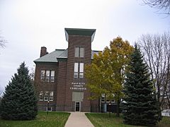
Palo Alto County Courthouse
|
|

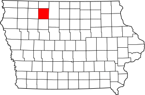
Location within the U.S. state of Iowa
|
|
 Iowa's location within the U.S. |
|
| Country | |
| State | |
| Founded | January 15, 1851 |
| Named for | Battle of Palo Alto |
| Seat | Emmetsburg |
| Largest city | Emmetsburg |
| Area | |
| • Total | 569 sq mi (1,470 km2) |
| • Land | 564 sq mi (1,460 km2) |
| • Water | 5.6 sq mi (15 km2) 1.0% |
| Population
(2020)
|
|
| • Total | 8,996 |
| • Density | 15.810/sq mi (6.104/km2) |
| Time zone | UTC−6 (Central) |
| • Summer (DST) | UTC−5 (CDT) |
| Congressional district | 4th |
Palo Alto County is a county in the state of Iowa, USA. In 2020, about 8,996 people lived there. The main town, or county seat, is Emmetsburg. The county got its name from the Battle of Palo Alto, which was an important battle in the Mexican–American War.
Contents
Geography of Palo Alto County
Palo Alto County covers a total area of about 569 square miles. Most of this area, about 564 square miles, is land. The remaining 5.6 square miles, or 1%, is water.
Main Roads in Palo Alto County
These are the major highways that run through Palo Alto County:
Neighboring Counties
Palo Alto County shares borders with these other counties:
- Emmet County (to the north)
- Kossuth County (to the east)
- Pocahontas County (to the south)
- Clay County (to the west)
Population and People
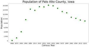
The population of Palo Alto County has changed over the years. A census is a count of all the people living in an area. It helps us understand how communities grow or shrink.
| Historical population | |||
|---|---|---|---|
| Census | Pop. | %± | |
| 1860 | 132 | — | |
| 1870 | 1,336 | 912.1% | |
| 1880 | 4,131 | 209.2% | |
| 1890 | 9,618 | 132.8% | |
| 1900 | 14,354 | 49.2% | |
| 1910 | 13,845 | −3.5% | |
| 1920 | 15,486 | 11.9% | |
| 1930 | 15,398 | −0.6% | |
| 1940 | 16,170 | 5.0% | |
| 1950 | 15,891 | −1.7% | |
| 1960 | 14,736 | −7.3% | |
| 1970 | 13,289 | −9.8% | |
| 1980 | 12,721 | −4.3% | |
| 1990 | 10,669 | −16.1% | |
| 2000 | 10,147 | −4.9% | |
| 2010 | 9,421 | −7.2% | |
| 2020 | 8,996 | −4.5% | |
| 2023 (est.) | 8,810 | −6.5% | |
| U.S. Decennial Census 1790–1960 1900–1990 1990–2000 2010–2018 |
|||
Recent Census Information

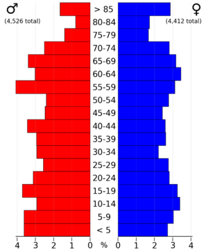
The 2020 census showed that 8,996 people lived in Palo Alto County. This means there were about 16 people per square mile. Most people (about 91%) were non-Hispanic White. There were also people from other backgrounds, including Hispanic, Black, Native American, and Asian.
The 2010 census counted 9,421 people in the county. This shows a slight decrease in population between 2010 and 2020.
Towns and Communities
Palo Alto County has several towns and smaller communities.
Cities in Palo Alto County
- Ayrshire
- Curlew
- Cylinder
- Emmetsburg
- Graettinger
- Mallard
- Rodman
- Ruthven
- West Bend (partially)
Townships in Palo Alto County
Townships are smaller areas within a county, often with their own local government.
- Booth
- Ellington
- Emmetsburg
- Fairfield
- Fern Valley
- Freedom
- Great Oak
- Highland
- Independence
- Lost Island
- Nevada
- Rush Lake
- Silver Lake
- Vernon
- Walnut
- West Bend
Largest Communities by Population
This table shows the biggest cities and towns in Palo Alto County, based on the 2020 census. † The county seat is the main town where the county government is located.
| Rank | City/Town | Type | Population (2020 Census) |
|---|---|---|---|
| 1 | † Emmetsburg | City | 3,706 |
| 2 | Graettinger | City | 832 |
| 3 | West Bend (partially in Kossuth County) | City | 772 (791 total) |
| 4 | Ruthven | City | 725 |
| 5 | Mallard | City | 257 |
| 6 | Ayrshire | City | 133 |
| 7 | Cylinder | City | 87 |
| 8 | Curlew | City | 37 |
| 9 | Rodman | City | 31 |
See also
 In Spanish: Condado de Palo Alto para niños


