Clay County, Iowa facts for kids
Quick facts for kids
Clay County
|
|
|---|---|

|
|

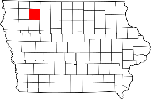
Location within the U.S. state of Iowa
|
|
 Iowa's location within the U.S. |
|
| Country | |
| State | |
| Founded | 1851 |
| Named for | Henry Clay Jr. |
| Seat | Spencer |
| Largest city | Spencer |
| Area | |
| • Total | 573 sq mi (1,480 km2) |
| • Land | 567 sq mi (1,470 km2) |
| • Water | 5.4 sq mi (14 km2) 0.9% |
| Population
(2020)
|
|
| • Total | 16,384 |
| • Estimate
(2023)
|
16,511 |
| • Density | 28.593/sq mi (11.040/km2) |
| Time zone | UTC−6 (Central) |
| • Summer (DST) | UTC−5 (CDT) |
| Congressional district | 4th |
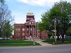
Clay County is a county in the state of Iowa. It's like a special area within the state. In 2020, about 16,384 people lived here. The main town, or county seat, is Spencer.
The county is named after Henry Clay Jr.. He was a brave soldier who died in the Mexican–American War. His father, also named Henry Clay, was a very famous American leader from Kentucky. Clay County is also home to the big Clay County Fair every year! The first newspaper in the county was the Peterson Patriot, which started in 1880.
Contents
Geography
Clay County covers about 573 square miles (1,480 km2) of land and water. Most of this area, about 567 square miles (1,470 km2), is land. The rest, about 5.4 square miles (14 km2), is water. A cool place in Clay County is the large Barringer Slough wetland, which is a watery, marshy area.
Major roads
You can get around Clay County using these important roads:
Airport
The Spencer Municipal Airport is located about three miles (4.8 km) northwest of Spencer. This airport helps people travel to and from the county and nearby towns.
Neighboring counties
Clay County shares its borders with these other counties:
- Dickinson County (to the north)
- Palo Alto County (to the east)
- Buena Vista County (to the south)
- O'Brien County (to the west)
Population facts
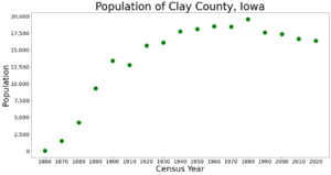
| Historical population | |||
|---|---|---|---|
| Census | Pop. | %± | |
| 1860 | 52 | — | |
| 1870 | 1,523 | 2,828.8% | |
| 1880 | 4,248 | 178.9% | |
| 1890 | 9,309 | 119.1% | |
| 1900 | 13,401 | 44.0% | |
| 1910 | 12,766 | −4.7% | |
| 1920 | 15,660 | 22.7% | |
| 1930 | 16,107 | 2.9% | |
| 1940 | 17,762 | 10.3% | |
| 1950 | 18,103 | 1.9% | |
| 1960 | 18,504 | 2.2% | |
| 1970 | 18,464 | −0.2% | |
| 1980 | 19,576 | 6.0% | |
| 1990 | 17,585 | −10.2% | |
| 2000 | 17,372 | −1.2% | |
| 2010 | 16,667 | −4.1% | |
| 2020 | 16,384 | −1.7% | |
| 2023 (est.) | 16,511 | −0.9% | |
| U.S. Decennial Census 1790-1960 1900-1990 1990-2000 2010-2018 |
|||
2020 census details

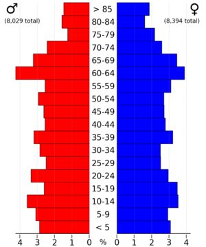
In 2020, the census counted 16,384 people living in Clay County. This means there were about 28.6719/sq mi (11.0703/km2) people per square mile. Most people (96.20%) said they belonged to one race. There were 8,109 homes, and 7,222 of them were lived in.
Here's a look at the different groups of people living in Clay County in 2020:
| Race | Number | Percentage |
|---|---|---|
| White (not Hispanic) | 15,025 | 92.8% |
| Black or African American (not Hispanic) | 99 | 0.6% |
| Native American (not Hispanic) | 37 | 0.23% |
| Asian (not Hispanic) | 105 | 0.64% |
| Pacific Islander (not Hispanic) | 2 | 0.01% |
| Other/Mixed (not Hispanic) | 412 | 2.51% |
| Hispanic or Latino | 704 | 4.3% |
2010 census details
The 2010 census showed that 16,667 people lived in Clay County. There were 8,062 homes, and 7,282 of them were lived in.
What people do for work
For a long time, farming has been a very important part of Clay County's economy. In the 1980s, there was a tough time for farmers, and some families had to stop farming. Over time, farms have become larger. The number of people living in the county has gone down a bit since 1980.
At one point, an airline company called Great Lakes Airlines had its main office in Summit Township, which is in Clay County.
Towns and areas
Cities
Here are the cities you can find in Clay County:
Townships
Clay County is also divided into smaller areas called townships:
- Clay
- Douglas
- Freeman
- Garfield
- Gillett Grove
- Herdland
- Lake
- Lincoln
- Logan
- Lone Tree
- Meadow
- Peterson
- Riverton
- Sioux
- Summit
- Waterford
City populations
This table shows how many people live in each city in Clay County, based on the 2020 census. † This means it's the county seat, or main town.
| Rank | City/Town/etc. | Type | Population (2021 Census) |
|---|---|---|---|
| 1 | † Spencer | City | 11,356 |
| 2 | Everly | City | 576 |
| 3 | Royal | City | 382 |
| 4 | Peterson | City | 324 |
| 5 | Fostoria | City | 232 |
| 6 | Dickens | City | 149 |
| 7 | Webb | City | 142 |
| 8 | Greenville | City | 69 |
| 9 | Rossie | City | 48 |
| 10 | Gillett Grove | City | 32 |
See also
 In Spanish: Condado de Clay (Iowa) para niños
 | Misty Copeland |
 | Raven Wilkinson |
 | Debra Austin |
 | Aesha Ash |


