Gillett Grove, Iowa facts for kids
Quick facts for kids
Gillett Grove, Iowa
|
|
|---|---|

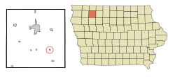
Location of Gillett Grove, Iowa
|
|
| Country | |
| State | |
| County | Clay |
| Area | |
| • Total | 0.22 sq mi (0.57 km2) |
| • Land | 0.22 sq mi (0.57 km2) |
| • Water | 0.00 sq mi (0.00 km2) |
| Elevation | 1,306 ft (398 m) |
| Population
(2020)
|
|
| • Total | 30 |
| • Density | 135.14/sq mi (52.19/km2) |
| Time zone | UTC-6 (Central (CST)) |
| • Summer (DST) | UTC-5 (CDT) |
| ZIP code |
51341
|
| Area code(s) | 712 |
| FIPS code | 19-30810 |
| GNIS feature ID | 0465642 |
Gillett Grove is a small city located in Clay County, Iowa, United States. In 2020, a count of the people living there, called a census, showed that 30 people lived in Gillett Grove. This number was lower than the 55 people counted in the year 2000.
Contents
History of Gillett Grove
Gillett Grove was established in 1899. This happened when the railroad tracks were extended to reach this area. The city was named after two brothers, George and Isaiah Gillett. They were among the first people to settle in this region.
Geography and Location
Gillett Grove is located in the state of Iowa. Its exact position on a map can be described using coordinates. These are 43.014514 degrees North and -95.036576 degrees West.
The United States Census Bureau studies areas like Gillett Grove. They found that the city covers a total area of about 0.19 square miles (0.49 square kilometers). All of this area is land, meaning there are no large bodies of water within the city limits.
Population and People
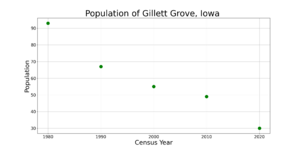
The number of people living in Gillett Grove has changed over the years. A census is a count of all the people in a place. Here's how the population has changed:
| Historical population | |||
|---|---|---|---|
| Census | Pop. | %± | |
| 1980 | 93 | — | |
| 1990 | 67 | −28.0% | |
| 2000 | 55 | −17.9% | |
| 2010 | 49 | −10.9% | |
| 2020 | 30 | −38.8% | |
| U.S. Decennial Census | |||
2020 Census Details
In 2020, the census showed that 30 people lived in Gillett Grove. These people lived in 19 different homes, called households. There were also 11 families. The city had about 135 people per square mile (52 people per square kilometer).
Most of the people living in Gillett Grove were White (96.7%). A small number (3.3%) were from two or more racial backgrounds. No one identified as Black, Native American, Asian, or Pacific Islander. Also, no one identified as Hispanic or Latino.
The average age of people in Gillett Grove was 45 years old.
- 10% of residents were under 20 years old.
- 6.7% were between 20 and 24 years old.
- 33.3% were between 25 and 44 years old.
- 20% were between 45 and 64 years old.
- 30% were 65 years old or older.
More males lived in the city (60%) than females (40%).
2010 Census Details
In 2010, the census counted 49 people in Gillett Grove. They lived in 24 households. About half of these households (50%) were not families. Most residents (98%) were White.
The average age in 2010 was 43.3 years.
- 20.4% of residents were under 18 years old.
- 12.3% were between 18 and 24 years old.
- 20.3% were between 25 and 44 years old.
- 26.6% were between 45 and 64 years old.
- 20.4% were 65 years old or older.
The number of males and females was almost equal, with 51% male and 49% female.
Education in Gillett Grove
Students living in Gillett Grove attend schools in the Spencer Community School District. Before July 1, 2010, the city was part of the South Clay Community School District. That district closed down, and part of it joined the Spencer district.
See also
 In Spanish: Gillett Grove (Iowa) para niños
 | Audre Lorde |
 | John Berry Meachum |
 | Ferdinand Lee Barnett |


