Dickinson County, Iowa facts for kids
Quick facts for kids
Dickinson County
|
|
|---|---|
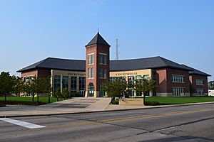
Dickinson County Courthouse
|
|
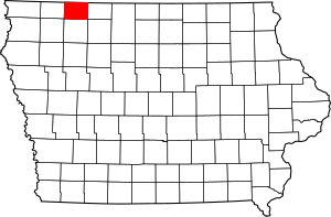
Location within the U.S. state of Iowa
|
|
 Iowa's location within the U.S. |
|
| Country | |
| State | |
| Founded | 1857 |
| Named for | Daniel S. Dickinson |
| Seat | Spirit Lake |
| Largest city | Spirit Lake |
| Area | |
| • Total | 404 sq mi (1,050 km2) |
| • Land | 381 sq mi (990 km2) |
| • Water | 23 sq mi (60 km2) 5.8% |
| Population
(2020)
|
|
| • Total | 17,703 |
| • Density | 43.82/sq mi (16.919/km2) |
| Time zone | UTC−6 (Central) |
| • Summer (DST) | UTC−5 (CDT) |
| Congressional district | 4th |
Dickinson County is a county in the state of Iowa, USA. It is known for its beautiful lakes, which make it a popular spot for vacations. In 2020, about 17,703 people lived here. The main city and county seat is Spirit Lake.
The county was officially started in 1857. It was named after Daniel S. Dickinson, who was a U.S. Senator from New York. Dickinson County is also part of the Spirit Lake, Iowa, area, which is a group of towns that are connected by their economy.
Contents
Exploring Dickinson County's Geography
Dickinson County covers a total area of 404 square miles (1,050 km2). Most of this is land, about 381 square miles (990 km2). The rest, about 23 square miles (60 km2), is water. This makes it the smallest county in Iowa when looking at just its land area.
The Iowa Great Lakes Region
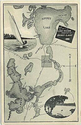
One of the most special parts of Dickinson County is the Iowa Great Lakes region. This area has many beautiful lakes, which is why so many people visit for holidays. The lakes are also why the number of people living here has grown a lot recently. Some of the main lakes include West Okoboji Lake, East Okoboji Lake, and Spirit Lake.
Main Roads in the County
Several important roads help people travel through Dickinson County:
Neighboring Counties
Dickinson County shares its borders with these other counties:
- Jackson County, Minnesota (to the north)
- Emmet County (to the east)
- Clay County (to the south)
- Osceola County (to the west)
People and Population in Dickinson County
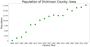
The number of people living in Dickinson County has changed a lot over the years. Here's how the population has grown since 1860:
| Historical population | |||
|---|---|---|---|
| Census | Pop. | %± | |
| 1860 | 180 | — | |
| 1870 | 1,389 | 671.7% | |
| 1880 | 1,901 | 36.9% | |
| 1890 | 4,328 | 127.7% | |
| 1900 | 7,995 | 84.7% | |
| 1910 | 8,137 | 1.8% | |
| 1920 | 10,241 | 25.9% | |
| 1930 | 10,982 | 7.2% | |
| 1940 | 12,185 | 11.0% | |
| 1950 | 12,756 | 4.7% | |
| 1960 | 12,574 | −1.4% | |
| 1970 | 12,565 | −0.1% | |
| 1980 | 15,629 | 24.4% | |
| 1990 | 14,909 | −4.6% | |
| 2000 | 16,424 | 10.2% | |
| 2010 | 16,667 | 1.5% | |
| 2020 | 17,703 | 6.2% | |
| 2023 (est.) | 18,056 | 8.3% | |
| U.S. Decennial Census 1790-1960 1900-1990 1990-2000 2010-2018 |
|||
What the 2020 Census Showed
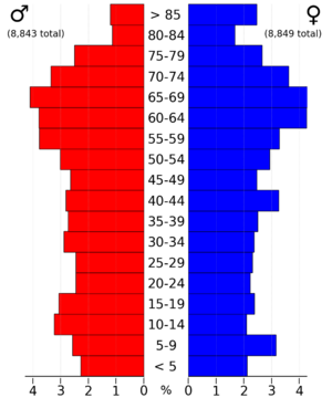
In 2020, the census counted 17,703 people in Dickinson County. This means there were about 43.6672/sq mi (16.8600/km2) people per square mile. Most people (about 96.84%) said they belonged to one race. About 92.71% were non-Hispanic White.
Towns and Communities
Dickinson County has several towns and communities. Some are cities, and one is an unincorporated community, meaning it doesn't have its own local government.
Cities in Dickinson County
Unincorporated Community
Townships in the County
Dickinson County is divided into twelve areas called townships. These are smaller parts of the county that help with local organization:
- Center Grove
- Diamond Lake
- Excelsior
- Lakeville
- Lloyd
- Milford
- Okoboji
- Richland
- Silver Lake
- Spirit Lake
- Superior
- Westport
Cities by Population Size
Here's a list of the cities in Dickinson County, ordered by how many people lived there in 2020. The symbol † means it's the county seat.
| Rank | City/Town/etc. | Municipal type | Population (2020 Census) |
|---|---|---|---|
| 1 | † Spirit Lake | City | 5,439 |
| 2 | Milford | City | 3,321 |
| 3 | Lake Park | City | 1,167 |
| 4 | Arnolds Park | City | 1,110 |
| 5 | Okoboji | City | 768 |
| 6 | Orleans | City | 521 |
| 7 | Wahpeton | City | 345 |
| 8 | Terril | City | 334 |
| 9 | West Okoboji | City | 308 |
| 10 | Superior | City | 132 |
See also
 In Spanish: Condado de Dickinson (Iowa) para niños
 | Frances Mary Albrier |
 | Whitney Young |
 | Muhammad Ali |


