Jackson County, Minnesota facts for kids
Quick facts for kids
Jackson County
|
|
|---|---|

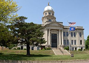
Jackson County gainCourthouse in Jackson
|
|

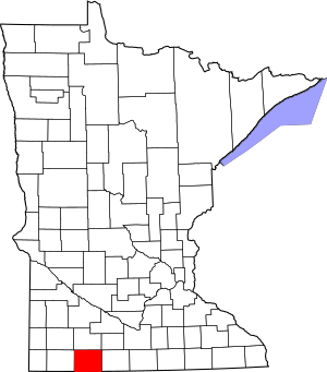
Location within the U.S. state of Minnesota
|
|
 Minnesota's location within the U.S. |
|
| Country | |
| State | |
| Founded | May 23, 1857 |
| Named for | Henry Jackson |
| Seat | Jackson |
| Largest city | Jackson |
| Area | |
| • Total | 719 sq mi (1,860 km2) |
| • Land | 703 sq mi (1,820 km2) |
| • Water | 16 sq mi (40 km2) 2.3%% |
| Population
(2020)
|
|
| • Total | 9,989 |
| • Estimate
(2023)
|
9,919 |
| • Density | 13.893/sq mi (5.364/km2) |
| Time zone | UTC−6 (Central) |
| • Summer (DST) | UTC−5 (CDT) |
| Congressional district | 1st |
Jackson County is a special area in the U.S. state of Minnesota, called a county. It's like a large neighborhood or district within the state. In 2020, about 9,989 people lived here. The main town, or county seat, where the county government is located, is called Jackson.
Contents
History of Jackson County
Jackson County was officially created on May 23, 1857. It was named after Henry Jackson. He was a very important person because he was the first merchant, or shop owner, in the city of St. Paul, Minnesota.
Geography and Nature
Jackson County is located right on Minnesota's border with the state of Iowa. The Des Moines River flows through the middle of the county, heading south into Iowa.
The land in Jackson County has many hills, valleys, and small streams. Most of the area is used for farming. The land generally slopes downwards towards the south and east. The highest point in the county is about 1,545 feet (471 meters) above sea level, found on the lower western border.
The county covers a total area of about 719 square miles (1,862 square kilometers). Most of this, about 703 square miles (1,821 square kilometers), is land. The remaining 16 square miles (41 square kilometers) is water, mostly from its many lakes and rivers.
Lakes in Jackson County
Jackson County is home to many beautiful lakes and water bodies. Some of these are shared with neighboring areas.
- Andersons Marsh
- Bennett Slough (Partially Drained)
- Boot Lake
- Chandler Lake
- Clear Lake (part)
- Clear Lake (Des Moines Township and Hunter Township)
- Fish Lake (part)
- Grovers Lake (part)
- Heron Lake (4 basins: Duck, North Marsh, North Lake, South Lake, connected by streams)
- Illinois Lake
- Independence Lake
- Iowa Lake (part)
- Lake Flaherty
- Laurs Lake
- Little Spirit Lake (part)
- Long Lake (Drained CD13)
- Loon Lake
- Pearl Lake
- Quevli and Goose Slough (Drained JD3)
- Quelvis Lake (Drained)
- Round Lake
- Rush Lake (Sioux Valley Township)
- Rush Lake (Minneota Township)
- Skunk Lake
- Spirit Lake
- String Lake (part)
- Swenson Lake (Drained)
- Teal Lake
- Timber Lake
Protected Natural Areas
Jackson County has many protected areas where nature is preserved. These include county parks, state wildlife management areas (WMAs), and scientific and natural areas (SNAs). These places help protect animals, plants, and important natural features.
- Anderson County Park
- Artz WMA
- Belmont County Park
- Bootleg Lake State Wildlife Management Area
- Brown County Park
- Caraway State Wildlife Management Area
- Christiana WPA
- Clear Lake Recreation Area
- Community Point County Park
- Cotton-Jack WMA
- Dead Horse WMA
- Des Moines River Scientific and Natural Area
- Fish Lake WPA
- Graham Creek WMA
- Heron Lake WMA
- Heron Meadows WMA
- Holthe Prairie Scientific and Natural Area
- Holy Trinity WPA
- Husen Wildlife Management Area
- Kilen Woods State Park
- Laurs Lake State Wildlife Management Area
- Lillegard WMA
- Little Sioux WMA
- Minnesota Slough State Wildlife Management Area
- Oxbow WMA
- Pietz Slough WMA
- Robertson County Park
- Rost WPA
- Sandy Point County Park
- Sangl State Wildlife Management Area
- Sioux Forks WPA
- Sioux Valley WMA
- Skunk Lake WMA
- String Lake WPA
- Summers State Wildlife Management Area
- Teal Lake WMA
- Timber Lake WMA
- Timber Lake WPA
- Toe WMA
- Valleau WMA
- Winkler WMA
Main Roads and Highways
Several important roads pass through Jackson County, making it easy to travel to and from the area.
 Interstate 90
 U.S. Highway 71
 Minnesota State Highway 60
 Minnesota State Highway 86
 Minnesota State Highway 264
Neighboring Counties
Jackson County shares its borders with several other counties. These are like its neighbors.
- Cottonwood County - to the north
- Watonwan County - to the northeast
- Martin County - to the east
- Emmet County, Iowa - to the southeast (in Iowa)
- Dickinson County, Iowa - to the south (in Iowa)
- Osceola County, Iowa - to the southwest (in Iowa)
- Nobles County - to the west
Population and People
The number of people living in Jackson County has changed over many years. Here's a look at how the population has grown and shrunk since 1860.
| Historical population | |||
|---|---|---|---|
| Census | Pop. | %± | |
| 1860 | 181 | — | |
| 1870 | 1,825 | 908.3% | |
| 1880 | 4,806 | 163.3% | |
| 1890 | 8,924 | 85.7% | |
| 1900 | 14,793 | 65.8% | |
| 1910 | 14,491 | −2.0% | |
| 1920 | 15,955 | 10.1% | |
| 1930 | 15,863 | −0.6% | |
| 1940 | 16,805 | 5.9% | |
| 1950 | 16,306 | −3.0% | |
| 1960 | 15,501 | −4.9% | |
| 1970 | 14,352 | −7.4% | |
| 1980 | 13,690 | −4.6% | |
| 1990 | 11,677 | −14.7% | |
| 2000 | 11,268 | −3.5% | |
| 2010 | 10,266 | −8.9% | |
| 2020 | 9,989 | −2.7% | |
| 2023 (est.) | 9,919 | −3.4% | |
| U.S. Decennial Census 1790–1960 1900–1990 1990–2000 2010–2020 |
|||
Who Lives in Jackson County?
The U.S. Census helps us understand the different groups of people who live in Jackson County. This table shows the different ethnic and racial backgrounds of residents in 2010 and 2020.
| Race / Ethnicity | Pop 2010 | Pop 2020 | % 2010 | % 2020 |
|---|---|---|---|---|
| White alone (NH) | 9,701 | 9,026 | 94.50% | 90.36% |
| Black or African American alone (NH) | 47 | 120 | 0.46% | 1.20% |
| Native American or Alaska Native alone (NH) | 15 | 22 | 0.15% | 0.22% |
| Asian alone (NH) | 136 | 122 | 1.33% | 1.22% |
| Pacific Islander alone (NH) | 0 | 0 | 0.00% | 0.00% |
| Some Other Race alone (NH) | 5 | 23 | 0.05% | 0.23% |
| Mixed Race/Multi-Racial (NH) | 85 | 275 | 0.83% | 2.75% |
| Hispanic or Latino (any race) | 277 | 401 | 2.70% | 4.01% |
| Total | 10,266 | 9,989 | 100.00% | 100.00% |
Note: The U.S. Census counts people who are Hispanic/Latino as an ethnic group. This means they can be of any race. The table above separates them from the racial categories.
Towns and Areas
Jackson County has several towns and communities where people live, work, and go to school.
Cities in Jackson County
These are the main cities in Jackson County:
Special Census Area
- Fish Lake is a place that the census bureau counts as a specific community, even if it's not a city.
Smaller Communities
These are smaller, unincorporated communities in the county. They don't have their own city government.
Townships in Jackson County
Townships are smaller divisions of land within a county, often rural areas.
- Alba Township
- Belmont Township
- Christiania Township
- Delafield Township
- Des Moines Township
- Enterprise Township
- Ewington Township
- Heron Lake Township
- Hunter Township
- Kimball Township
- La Crosse Township
- Middletown Township
- Minneota Township
- Petersburg Township
- Rost Township
- Round Lake Township
- Sioux Valley Township
- Weimer Township
- West Heron Lake Township
- Wisconsin Township
See also
 In Spanish: Condado de Jackson (Minnesota) para niños
 | Kyle Baker |
 | Joseph Yoakum |
 | Laura Wheeler Waring |
 | Henry Ossawa Tanner |


