Osceola County, Iowa facts for kids
Quick facts for kids
Osceola County
|
|
|---|---|

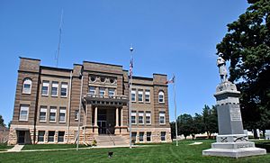
Osceola County Courthouse, July 2014
|
|

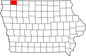
Location within the U.S. state of Iowa
|
|
 Iowa's location within the U.S. |
|
| Country | |
| State | |
| Founded | 1871 |
| Named for | Osceola |
| Seat | Sibley |
| Largest city | Sibley |
| Area | |
| • Total | 399 sq mi (1,030 km2) |
| • Land | 399 sq mi (1,030 km2) |
| • Water | 0.7 sq mi (2 km2) 0.2% |
| Population
(2020)
|
|
| • Total | 6,192 |
| • Density | 15.519/sq mi (5.992/km2) |
| Time zone | UTC−6 (Central) |
| • Summer (DST) | UTC−5 (CDT) |
| Congressional district | 4th |
Osceola County is a county located in the U.S. state of Iowa. It's named after Osceola, a famous war chief of the Seminole people.
As of the 2020 census, about 6,192 people live here. This makes it one of the least populated counties in Iowa. The main town, or county seat, is Sibley. Sibley was named after H. H. Sibley from Minnesota.
Contents
History of Osceola County
Osceola County was officially created in 1871. It is the smallest and newest county in Iowa. It was named after the brave Seminole chief Osceola.
In the same year, the first settler arrived. His name was Captain Eldred Huff, and he claimed his land. The county government held its first meeting on January 1, 1872.
The first courthouse was built from wood in November 1872. It was a very busy building! It served as the meeting place for the government, a school, and even a church. A new courthouse was finished in September 1903. It got electricity in October 1915.
Geography of Osceola County
Osceola County covers about 399 square miles (1,033 square kilometers). Most of this area is land, with only a tiny bit of water. It is the third smallest county in Iowa by land area.
Did you know the highest natural point in Iowa is in Osceola County? It's called Hawkeye Point and it stands about 1,670 feet (509 meters) high!
Main Roads in Osceola County
Neighboring Counties
Osceola County shares borders with these other counties:
- Nobles County, Minnesota (to the north-west)
- Jackson County, Minnesota (to the north-east)
- Dickinson County (to the east)
- O'Brien County (to the south)
- Lyon County (to the west)
Population of Osceola County

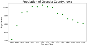
The population of Osceola County has changed over the years. In 1880, there were 2,219 people. The population grew to over 10,000 in the 1920s and 1930s. Since then, it has slowly decreased.
2020 Census Information
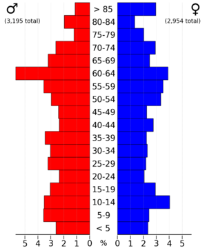
The 2020 census counted 6,192 people living in Osceola County. This means there are about 15 people per square mile. There were 2,878 homes in the county, and 2,599 of them were lived in.
Most people in Osceola County are White. About 86.3% of the population is White. Other groups include Black or African American, Native American, Asian, and Pacific Islander. About 9.74% of the population is Hispanic or Latino.
Cities and Towns in Osceola County
Osceola County has several cities and many smaller areas called townships.
Cities
Townships
- Allison
- Baker
- East Holman
- Fairview
- Gilman
- Goewey
- Harrison
- Horton
- Ocheyedan
- Viola
- West Holman
- Wilson
Smaller Communities (Unincorporated)
These are smaller places that are not officially cities or towns:
Largest Cities by Population
Here are the cities in Osceola County, ranked by how many people lived there in 2020:
| Rank | City/Town | Type | Population (2020 Census) |
|---|---|---|---|
| 1 | † Sibley | City | 2,860 |
| 2 | Ocheyedan | City | 439 |
| 3 | Ashton | City | 436 |
| 4 | Melvin | City | 199 |
| 5 | Harris | City | 151 |
† Sibley is the county seat.
See also
 In Spanish: Condado de Osceola (Iowa) para niños
 | May Edward Chinn |
 | Rebecca Cole |
 | Alexa Canady |
 | Dorothy Lavinia Brown |


