Melvin, Iowa facts for kids
Quick facts for kids
Melvin, Iowa
|
|
|---|---|

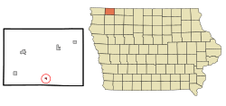
Location of Melvin, Iowa
|
|
| Country | |
| State | |
| County | Osceola |
| Area | |
| • Total | 0.16 sq mi (0.42 km2) |
| • Land | 0.16 sq mi (0.42 km2) |
| • Water | 0.00 sq mi (0.00 km2) |
| Elevation | 1,581 ft (482 m) |
| Population
(2020)
|
|
| • Total | 199 |
| • Density | 1,228.40/sq mi (473.14/km2) |
| Time zone | UTC-6 (Central (CST)) |
| • Summer (DST) | UTC-5 (CDT) |
| ZIP code |
51350
|
| Area code(s) | 712 |
| FIPS code | 19-51060 |
| GNIS feature ID | 0458961 |
Melvin is a small city located in Osceola County, Iowa, in the United States. In 2020, a count of its residents, called the 2020 census, showed that 199 people lived there.
Contents
History of Melvin
Melvin started to grow in the year 1900. This happened when the Rock Island Railroad built a new train line, known as the Gowrie branch, through this area. The railroad helped the town develop.
An interesting fact about Melvin is that it was once the home of the famous MARVIN robot. This robot was created in 1983 by a company called Iowa Precision Robotics.
Melvin's Geography
Melvin is located at specific coordinates: 43.286659 degrees North and -95.607462 degrees West. These numbers help pinpoint its exact spot on a map.
The United States Census Bureau reports that the city covers a total area of about 0.42 square kilometers (or 0.16 square miles). All of this area is land, meaning there are no large bodies of water like lakes or rivers within the city limits.
Melvin's Population Data
The population of Melvin has changed over the years. A census is a count of all the people living in a place at a certain time. Here's how Melvin's population has looked:
| Historical population | |||
|---|---|---|---|
| Census | Pop. | %± | |
| 1910 | 195 | — | |
| 1920 | 282 | 44.6% | |
| 1930 | 301 | 6.7% | |
| 1940 | 328 | 9.0% | |
| 1950 | 325 | −0.9% | |
| 1960 | 364 | 12.0% | |
| 1970 | 325 | −10.7% | |
| 1980 | 277 | −14.8% | |
| 1990 | 250 | −9.7% | |
| 2000 | 243 | −2.8% | |
| 2010 | 214 | −11.9% | |
| 2020 | 199 | −7.0% | |
| U.S. Decennial Census | |||
2020 Census Details
In 2020, the census showed that 199 people lived in Melvin. There were 95 households, which are groups of people living together in one home. Out of these, 54 were families.
The city had about 1,225 people per square mile (or 473 people per square kilometer). There were 117 housing units, which are places where people can live.
Most of the people in Melvin were White (88.4%). About 11.6% of the population identified as Hispanic or Latino.
About 18.9% of households had children under 18 living with them. Many households (41.1%) were married couples living together. The median age in Melvin was 50.8 years. This means half the people were older than 50.8, and half were younger.
2010 Census Details
In 2010, Melvin had 214 people living in the city. There were 109 households and 63 families. The population density was about 1,189 people per square mile.
Most residents (97.7%) were White. About 1.4% of the population identified as Hispanic or Latino.
About 18.3% of households had children under 18. The median age was 51.1 years. This means the population was generally older, with a significant portion of residents aged 45 and above.
Education in Melvin
Melvin is part of the Hartley–Melvin–Sanborn Community School District. This school district was formed in 1991 when two smaller districts, Hartley–Melvin and Sanborn, joined together. Before that, the Hartley–Melvin district was created in 1981 by combining the Hartley and Melvin school districts.
Currently, there are no school buildings located directly in Melvin. The last school in Melvin closed when the Hartley and Melvin schools combined in 1980. Students from Melvin attend Hartley–Melvin–Sanborn High School for their high school education.
See also
 In Spanish: Melvin (Iowa) para niños
 | Laphonza Butler |
 | Daisy Bates |
 | Elizabeth Piper Ensley |

