O'Brien County, Iowa facts for kids
Quick facts for kids
O'Brien County
|
|
|---|---|

|
|

Location within the U.S. state of Iowa
|
|
 Iowa's location within the U.S. |
|
| Country | |
| State | |
| Founded | January 15, 1851 |
| Named for | William Smith O'Brien |
| Seat | Primghar |
| Largest city | Sheldon |
| Area | |
| • Total | 573 sq mi (1,480 km2) |
| • Land | 573 sq mi (1,480 km2) |
| • Water | 0.2 sq mi (0.5 km2) 0.03% |
| Population
(2020)
|
|
| • Total | 14,182 |
| • Density | 24.750/sq mi (9.556/km2) |
| Time zone | UTC−6 (Central) |
| • Summer (DST) | UTC−5 (CDT) |
| Congressional district | 4th |
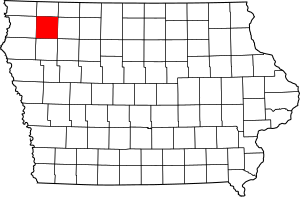
O'Brien County is a county located in the state of Iowa in the United States. In 2020, about 14,182 people lived here. The main town and county seat is Primghar.
Contents
History of O'Brien County
When Iowa became a state in 1848, it already had 44 counties. On January 15, 1851, the state created 49 more counties. O'Brien County was one of these new areas. It was named after William Smith O'Brien, an important leader who fought for Irish independence in 1848.
The first person to settle in O'Brien County arrived in 1856. His name was Hannibal H. Waterman. He moved with his wife and daughter to the southeastern part of the county. This area is now called Waterman Township. A small building was built there to be the first courthouse.
By 1872, several small towns had grown in the county. People thought the county's main office should be in a more central spot. So, they held an election. The people decided to create a new county seat right in the middle of the county.
A piece of land, about 40 acres big, was measured and mapped out. This new town was named Primghar. Its name came from the first letters of eight people who helped plan the town. The old courthouse building was then moved to Primghar.
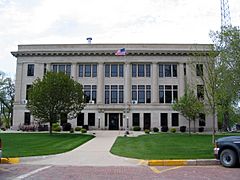
In 1874, a new, larger building was built for the courthouse. It cost $2,000. This building was replaced again in 1887 with an even bigger one. The county leaders approved building it, but it couldn't cost more than $5,000. To save money, people from the new town helped by hauling building materials for free. They brought them from the railroad stops in Sanborn and Paullina. The current courthouse was finished in 1917. It is now listed as a historic place.
Geography of O'Brien County
O'Brien County covers about 573 square miles. Almost all of this area is land. Only a tiny part, about 0.2 square miles, is water.
Main Roads in O'Brien County
Neighboring Counties
O'Brien County shares borders with these other counties:
- Osceola County to the north
- Clay County to the east
- Cherokee County to the south
- Sioux County to the west
Population of O'Brien County
| Historical population | |||
|---|---|---|---|
| Census | Pop. | %± | |
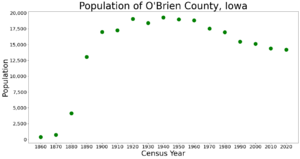
| 1860 | 383 | — | |
| 1870 | 715 | 86.7% | |
| 1880 | 4,155 | 481.1% | |
| 1890 | 13,060 | 214.3% | |
| 1900 | 16,985 | 30.1% | |
| 1910 | 17,262 | 1.6% | |
| 1920 | 19,051 | 10.4% | |
| 1930 | 18,409 | −3.4% | |
| 1940 | 19,293 | 4.8% | |
| 1950 | 18,970 | −1.7% | |
| 1960 | 18,840 | −0.7% | |
| 1970 | 17,522 | −7.0% | |
| 1980 | 16,972 | −3.1% | |
| 1990 | 15,444 | −9.0% | |
| 2000 | 15,102 | −2.2% | |
| 2010 | 14,398 | −4.7% | |
| 2020 | 14,182 | −1.5% | |
| 2023 (est.) | 14,012 | −2.7% | |
| US Decennial Census 1790-1960 1900-1990 1990-2000 2010-2018 |
|||
2020 Census Information
In 2020, the census counted 14,182 people living in O'Brien County. Most of the people, about 89%, identified as White. About 7% of the population identified as Hispanic or Latino. Other groups made up smaller percentages. There were 6,524 homes in the county, and most of them were lived in.

2010 Census Information
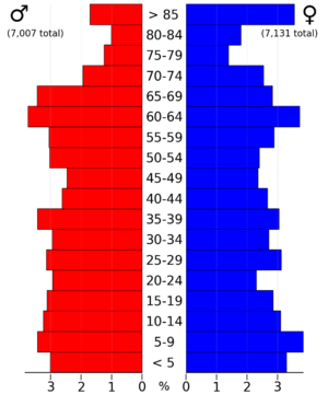
In 2010, there were 14,398 people in O'Brien County. There were 6,069 households, which means groups of people living together in homes. About 26% of these households had children under 18. Most households were made up of married couples.
The average age of people in the county was about 43.6 years old. About 25.7% of the population was under 20 years old. About 20.4% of the people were 65 years or older.
Towns and Communities
Cities in O'Brien County
Smaller Communities (Unincorporated)
These are smaller places that are not officially cities:
Townships in O'Brien County
A township is a small area of land within a county. O'Brien County has many townships:
- Baker Township
- Caledonia Township
- Carroll Township
- Center Township
- Dale Township
- Floyd Township
- Franklin Township
- Grant Township
- Hartley Township
- Highland Township
- Liberty Township
- Lincoln Township
- Omega Township
- Summit Township
- Union Township
- Waterman Township
Largest Cities by Population (2020 Census)
This table shows the cities in O'Brien County from largest to smallest population.
† county seat
| Rank | City/Town/etc. | Type | Population (2020 Census) |
|---|---|---|---|
| 1 | Sheldon (partially in Sioux County) | City | 5,251 (5,512 total) |
| 2 | Hartley | City | 1,605 |
| 3 | Sanborn | City | 1,392 |
| 4 | Paullina | City | 982 |
| 5 | † Primghar | City | 896 |
| 6 | Sutherland | City | 629 |
| 7 | Calumet | City | 146 |
| 8 | Archer | City | 117 |
See also
 In Spanish: Condado de O'Brien para niños
 | Bayard Rustin |
 | Jeannette Carter |
 | Jeremiah A. Brown |


