Cherokee County, Iowa facts for kids
Quick facts for kids
Cherokee County
|
|
|---|---|

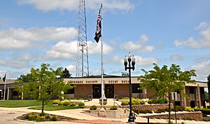
Cherokee County Courthouse, July 2014
|
|

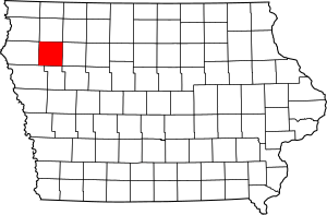
Location within the U.S. state of Iowa
|
|
 Iowa's location within the U.S. |
|
| Country | |
| State | |
| Founded | 1851 |
| Named for | Cherokee people |
| Seat | Cherokee |
| Largest city | Cherokee |
| Area | |
| • Total | 577 sq mi (1,490 km2) |
| • Land | 577 sq mi (1,490 km2) |
| • Water | 0.2 sq mi (0.5 km2) 0.03% |
| Population
(2020)
|
|
| • Total | 11,658 |
| • Density | 20.205/sq mi (7.801/km2) |
| Time zone | UTC−6 (Central) |
| • Summer (DST) | UTC−5 (CDT) |
| Congressional district | 4th |
Cherokee County is a place in the state of Iowa, USA. It's called a county, which is like a smaller region within a state. In 2020, about 11,658 people lived here. The main town, or county seat, is Cherokee. Cherokee County was created on January 15, 1851. It was named after the Cherokee people.
Contents
Geography of Cherokee County
Cherokee County covers a total area of about 577 square miles. Almost all of this area is land. Only a tiny part, about 0.2 square miles, is water.
Main Roads in Cherokee County
These are the most important highways that run through Cherokee County:
Neighboring Counties
Cherokee County shares borders with these other counties:
- O'Brien County to the north
- Buena Vista County to the east
- Ida County to the south
- Woodbury County to the southwest
- Plymouth County to the west
People of Cherokee County (Demographics)
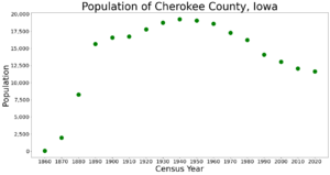
| Historical population | |||
|---|---|---|---|
| Census | Pop. | %± | |
| 1860 | 58 | — | |
| 1870 | 1,967 | 3,291.4% | |
| 1880 | 8,240 | 318.9% | |
| 1890 | 15,659 | 90.0% | |
| 1900 | 16,570 | 5.8% | |
| 1910 | 16,741 | 1.0% | |
| 1920 | 17,760 | 6.1% | |
| 1930 | 18,737 | 5.5% | |
| 1940 | 19,258 | 2.8% | |
| 1950 | 19,052 | −1.1% | |
| 1960 | 18,598 | −2.4% | |
| 1970 | 17,269 | −7.1% | |
| 1980 | 16,238 | −6.0% | |
| 1990 | 14,098 | −13.2% | |
| 2000 | 13,035 | −7.5% | |
| 2010 | 12,072 | −7.4% | |
| 2020 | 11,658 | −3.4% | |
| 2023 (est.) | 11,605 | −3.9% | |
| U.S. Decennial Census 1790-1960 1900-1990 1990-2000 2010-2018 |
|||
What the 2020 Census Showed
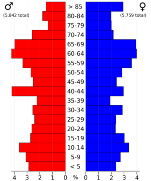
The 2020 census counted 11,658 people living in Cherokee County. This means there were about 20 people for every square mile. Most people (96.59%) said they belonged to one race. About 88.36% were non-Hispanic White. Other groups included Black people (0.75%), Hispanic people (4.55%), Native Americans (0.28%), and Asian people (0.49%).
There were 5,558 homes in the county. Out of these, 5,008 homes were lived in.
What the 2010 Census Showed
In 2010, the census recorded 12,072 people in Cherokee County. This was a bit more than in 2020. There were 5,777 homes, and 5,207 of them were lived in.
Cities and Towns in Cherokee County
Cities
Townships
Cherokee County is also divided into smaller areas called townships. There are sixteen of them:
- Afton
- Amherst
- Cedar
- Cherokee
- Diamond
- Grand Meadow
- Liberty
- Marcus
- Pilot
- Pitcher
- Rock
- Sheridan
- Silver
- Spring
- Tilden
- Willow
How Cities Rank by Population
This table shows the cities in Cherokee County from largest to smallest, based on the 2020 census.
† county seat
| Rank | City/Town/etc. | Type | Population (2020 Census) |
|---|---|---|---|
| 1 | † Cherokee | City | 5,199 |
| 2 | Marcus | City | 1,079 |
| 3 | Aurelia | City | 968 |
| 4 | Quimby | City | 249 |
| 5 | Washta | City | 209 |
| 6 | Cleghorn | City | 240 |
| 7 | Meriden | City | 161 |
| 8 | Larrabee | City | 123 |
See also
 In Spanish: Condado de Cherokee (Iowa) para niños
 | John T. Biggers |
 | Thomas Blackshear |
 | Mark Bradford |
 | Beverly Buchanan |


