Ida County, Iowa facts for kids
Quick facts for kids
Ida County
|
|
|---|---|

|
|

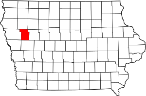
Location within the U.S. state of Iowa
|
|
 Iowa's location within the U.S. |
|
| Country | |
| State | |
| Founded | January 15, 1851 |
| Seat | Ida Grove |
| Largest city | Ida Grove |
| Area | |
| • Total | 432 sq mi (1,120 km2) |
| • Land | 432 sq mi (1,120 km2) |
| • Water | 0.5 sq mi (1 km2) 0.1% |
| Population
(2020)
|
|
| • Total | 7,005 |
| • Density | 16.215/sq mi (6.261/km2) |
| Time zone | UTC−6 (Central) |
| • Summer (DST) | UTC−5 (CDT) |
| Congressional district | 4th |
Ida County is a place in the U.S. state of Iowa. It is a type of local government area called a county. In 2020, about 7,005 people lived here. This makes it one of the smaller counties in Iowa. The main town, or county seat, is Ida Grove. Ida County was officially created in January 1851. It was named after Ida Smith, who was the first child of European settlers born in this area.
Contents
History of Ida County
The state of Iowa decided to create 49 new counties on January 15, 1851. Ida County was one of them. But at first, no one lived there. So, no local government was set up right away.
In 1853, the state said that Ida County would be part of Woodbury County. This was for things like taxes and elections. Still, no settlers lived in Ida County at that time.
First Settlers and Growth
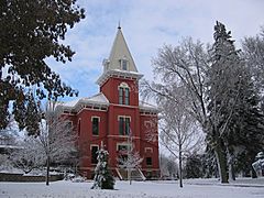
The first people to live permanently in Ida County arrived in 1856. Their names were Comstock and Moorehead. In 1858, the county government officially started. John Moorehead became the first County Judge. About 40 people lived in the county then.
Judge Moorehead's house was very important. It was the county's only post office. It also served as the first courthouse.
The first building just for a school was built in 1861. In 1872, the county got its first newspaper, called Ida County Pioneer. The first bank opened in 1876.
Railroads came to Ida County in 1877. This was the Maple Valley branch of the Chicago & North Western Railway. The railroads brought many new settlers. Within five years, almost all the land was bought.
Geography of Ida County
Ida County covers about 432 square miles. Most of this area is land. Only a tiny part, about 0.5 square miles, is water.
Main Roads in Ida County
 U.S. Highway 20 – This road goes from east to west through the northern part of the county. It passes through the town of Holstein.
 U.S. Highway 59 – This road generally goes from north to south through the middle of the county. It passes through Ida Grove.
 Iowa Highway 31 – This road crosses the very northwest corner of Ida County.
 Iowa Highway 175 – This road goes from east to west through the southern part of the county. It also passes through Ida Grove.
Neighboring Counties
Ida County shares borders with these other counties:
- Cherokee County (to the north)
- Sac County (to the east)
- Crawford County (to the south)
- Woodbury County (to the west)
Population of Ida County
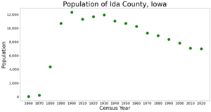
A census is a count of all the people living in a place. The United States does a census every ten years.
| Historical population | |||
|---|---|---|---|
| Census | Pop. | %± | |
| 1860 | 43 | — | |
| 1870 | 226 | 425.6% | |
| 1880 | 4,382 | 1,838.9% | |
| 1890 | 10,705 | 144.3% | |
| 1900 | 12,327 | 15.2% | |
| 1910 | 11,296 | −8.4% | |
| 1920 | 11,689 | 3.5% | |
| 1930 | 11,933 | 2.1% | |
| 1940 | 11,047 | −7.4% | |
| 1950 | 10,697 | −3.2% | |
| 1960 | 10,269 | −4.0% | |
| 1970 | 9,283 | −9.6% | |
| 1980 | 8,908 | −4.0% | |
| 1990 | 8,365 | −6.1% | |
| 2000 | 7,837 | −6.3% | |
| 2010 | 7,089 | −9.5% | |
| 2020 | 7,005 | −1.2% | |
| 2023 (est.) | 6,833 | −3.6% | |
| U.S. Decennial Census 1790-1960 1900-1990 1990-2000 2010-2018 2020-2022 |
|||
2020 Census Information
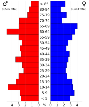
In the 2020 census, Ida County had 7,005 people. This means there were about 16 people for every square mile. Most people (97.32%) said they were of one race. About 91.46% were non-Hispanic White. About 3.64% were Hispanic.
There were 3,352 homes or places to live in the county. Out of these, 2,940 were lived in.
2010 Census Information
The 2010 census counted 7,089 people in Ida County. There were 3,426 homes, and 3,052 of them were lived in.
Communities in Ida County
Ida County has several towns and smaller areas called townships.
Cities in Ida County
Townships in Ida County
- Battle
- Blaine
- Corwin
- Douglas
- Galva
- Garfield
- Grant
- Griggs
- Hayes
- Logan
- Maple
- Silver Creek
City Populations (2020 Census)
This table shows the cities in Ida County and how many people lived in them in 2020.
† county seat
| Rank | City/Town/etc. | Type | Population (2020 Census) |
|---|---|---|---|
| 1 | † Ida Grove | City | 2,051 |
| 2 | Holstein | City | 1,501 |
| 3 | Battle Creek | City | 700 |
| 4 | Galva | City | 435 |
| 5 | Arthur | City | 222 |
Education in Ida County
Here are the school districts that serve students in Ida County:
- Denison Community School District
- Galva-Holstein Community School District
- Maple Valley-Anthon Oto Community School District
- Odebolt Arthur Battle Creek Ida Grove Community School District
- River Valley Community School District
- Schaller-Crestland Community School District
- Schleswig Community School District
Some school districts that used to exist in the area include:
- Battle Creek-Ida Grove Community School District
- Maple Valley Community School District
- Odebolt-Arthur Community School District
See also
 In Spanish: Condado de Ida para niños
 | Shirley Ann Jackson |
 | Garett Morgan |
 | J. Ernest Wilkins Jr. |
 | Elijah McCoy |


