Lyon County, Iowa facts for kids
Quick facts for kids
Lyon County
|
|
|---|---|
|
|
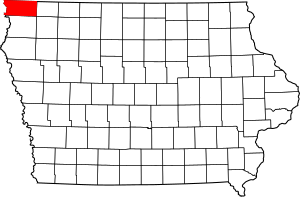
Location within the U.S. state of Iowa
|
|
 Iowa's location within the U.S. |
|
| Country | |
| State | |
| Founded | January 15, 1851 |
| Named for | Nathaniel Lyon |
| Seat | Rock Rapids |
| Largest city | Rock Rapids |
| Area | |
| • Total | 588 sq mi (1,520 km2) |
| • Land | 588 sq mi (1,520 km2) |
| • Water | 0.1 sq mi (0.3 km2) 0.02% |
| Population
(2020)
|
|
| • Total | 11,934 |
| • Density | 20.296/sq mi (7.836/km2) |
| Time zone | UTC−6 (Central) |
| • Summer (DST) | UTC−5 (CDT) |
| Congressional district | 4th |
Lyon County is a county located in the very northwest corner of Iowa, a state in the United States. As of the 2020 census, about 11,934 people lived there. The main town and county seat (where the county government is) is Rock Rapids.
Lyon County is named after Brigadier General Nathaniel Lyon. He was a brave soldier who fought in the Mexican–American War and the Civil War. General Lyon was killed in a battle in Missouri in 1861. The county was named in his honor after his death. Before that, the county was called Buncombe County, but its name was changed in 1862.
Contents
History of Lyon County
The land that is now Lyon County was once home to the Sioux Native American Tribe. They gave the land to the United States government through a special agreement called a treaty in 1851. The borders of Lyon County were officially set on January 15, 1851. For a while, it was managed by Woodbury County. Then, on January 1, 1872, Lyon County became its own separate county.
The first non-Native American person to live in Lyon County was Daniel McLaren, who people called "Uncle Dan." He lived near the Sioux River for a short time, hunting and trapping animals. He later moved further west. Another early settler was "Old Tom," who also hunted and trapped near where Rock Rapids is today. Sadly, Old Tom was killed by Sioux tribespeople while checking his traps.
In 1862 and 1863, a group of hunters from the east coast visited the county. Their names were Roy McGregor, George Clark, and Thomas Lockhart. One winter day, Lockhart and McGregor were hunting elk. They met a group of Sioux tribespeople, and Lockhart was killed. McGregor managed to escape and found Clark. The two continued to hunt until March 1863. During a spring flood, Clark drowned, and McGregor decided to return home to the east.
The first lasting settlement in Lyon County was started by Lewis P. Hyde in July 1866. By 1869, the county's population reached 100 people, all of whom had moved there. The first non-Native American child born in the county was Odena Lee, on May 28, 1871. The first election in the county took place on October 10, 1871, and 97 people voted.
Geography and Nature
Lyon County covers a total area of about 588 square miles. Almost all of this area is land, with only a tiny bit being water.
One special place in Lyon County is Gitchie Manitou State Preserve. This preserve has some of the oldest rocks in the entire country that are visible on the surface.
There's also a lake called Lake Pahoja in the northwest part of the county. It's a lake made by people and covers more than 28 hectares (about 69 acres).
Main Roads
- U.S. Highway 18
- U.S. Highway 75
- Iowa Highway 9
- Iowa Highway 182
Neighboring Counties
Lyon County shares its borders with several other counties:
- Rock County, Minnesota (to the north)
- Nobles County, Minnesota (to the northeast)
- Osceola County (to the east)
- Sioux County (to the south)
- Lincoln County, South Dakota (to the west)
- Minnehaha County, South Dakota (to the northwest)
Population Information
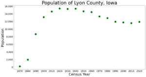
| Historical population | |||
|---|---|---|---|
| Census | Pop. | %± | |
| 1870 | 221 | — | |
| 1880 | 1,968 | 790.5% | |
| 1890 | 8,680 | 341.1% | |
| 1900 | 13,165 | 51.7% | |
| 1910 | 14,624 | 11.1% | |
| 1920 | 15,431 | 5.5% | |
| 1930 | 15,293 | −0.9% | |
| 1940 | 15,374 | 0.5% | |
| 1950 | 14,697 | −4.4% | |
| 1960 | 14,468 | −1.6% | |
| 1970 | 13,340 | −7.8% | |
| 1980 | 12,896 | −3.3% | |
| 1990 | 11,952 | −7.3% | |
| 2000 | 11,763 | −1.6% | |
| 2010 | 11,581 | −1.5% | |
| 2020 | 11,934 | 3.0% | |
| 2023 (est.) | 12,324 | 6.4% | |
| U.S. Decennial Census 1790-1960 1900-1990 1990-2000 2010-2018 |
|||
2020 Census Details
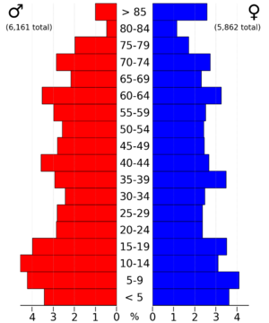
In 2020, the census counted 11,934 people living in Lyon County. This means there were about 20 people for every square mile. Most people (97.19%) reported being of one race. About 91.03% were non-Hispanic White. Other groups included Black people (0.34%), Hispanic people (3.41%), Native American people (0.27%), Asian people (0.20%), and Native Hawaiian or Pacific Islander people (0.39%). About 4.37% were from other races or more than one race. There were 4,817 homes in the county, and 4,466 of them were lived in.
2010 Census Details
The 2010 census showed that 11,581 people lived in Lyon County. There were 4,848 homes, and 4,442 of them were occupied.
Towns and Communities
Cities in Lyon County
Smaller Communities (Unincorporated)
These are places that are not officially cities or towns.
Townships
Townships are smaller areas within a county, often used for local government.
- Allison
- Centennial
- Cleveland
- Dale
- Doon
- Elgin
- Garfield
- Grant
- Larchwood
- Liberal
- Logan
- Lyon
- Midland
- Richland
- Riverside
- Rock
- Sioux
- Wheeler
City Populations (2020 Census)
This table shows the population of the cities in Lyon County, based on the 2020 census.
† This symbol means it's the county seat.
| Rank | City/Town/etc. | Type | Population (2020 Census) |
|---|---|---|---|
| 1 | † Rock Rapids | City | 2,611 |
| 2 | George | City | 1,077 |
| 3 | Inwood | City | 928 |
| 4 | Larchwood | City | 926 |
| 5 | Doon | City | 619 |
| 6 | Little Rock | City | 439 |
| 7 | Lester | City | 296 |
| 8 | Alvord | City | 206 |
See also
 In Spanish: Condado de Lyon (Iowa) para niños


