Lincoln County, South Dakota facts for kids
Quick facts for kids
Lincoln County
|
|
|---|---|

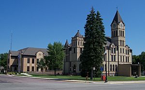
Lincoln County Courthouse in Canton
|
|

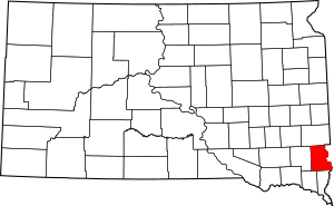
Location within the U.S. state of South Dakota
|
|
 South Dakota's location within the U.S. |
|
| Country | |
| State | |
| Founded | December 30, 1867 |
| Named for | Abraham Lincoln |
| Seat | Canton |
| Largest city | Sioux Falls |
| Area | |
| • Total | 578 sq mi (1,500 km2) |
| • Land | 577 sq mi (1,490 km2) |
| • Water | 0.5 sq mi (1 km2) 0.08% |
| Population
(2020)
|
|
| • Total | 65,161 |
| • Estimate
(2023)
|
73,238 |
| • Density | 112.74/sq mi (43.53/km2) |
| Time zone | UTC−6 (Central) |
| • Summer (DST) | UTC−5 (CDT) |
| Congressional district | At-large |
Lincoln County is a special area in the U.S. state of South Dakota. It's called a county. In 2020, about 65,161 people lived here, making it the third most populated county in South Dakota. The main town, or county seat, is Canton.
This county got its name from Abraham Lincoln, who was the 16th President of the United States. Lincoln County is part of the larger Sioux Falls metropolitan area. It's one of the fastest-growing counties in the whole United States! This is because the nearby city of Sioux Falls is growing south, and more people are moving to the towns around it.
Contents
Geography of Lincoln County
Lincoln County is located on the eastern side of South Dakota. The Big Sioux River flows along its eastern border. This river separates Lincoln County from the state of Iowa.
The land in the county has gentle, rolling hills. Most of the area is used for farming. The land slopes down towards the southeast and drops into the river valley on the eastern edge. The county covers a total area of about 578 square miles. Almost all of this is land (577 square miles), with a small amount (0.5 square miles) being water.
Lakes to Explore
- Lake Alvin
- Lake Lakota
Special Protected Areas
Lincoln County has several protected areas where nature is preserved. These include:
- Atkins Waterfowl Production Area
- Fish State Game Production Area
- Good Earth State Park
- Johnson State Game Production Area
- Klondike State Game Production Area
- Lake Alvin State Game Production Area
- Lake Alvin State Recreation Area
- McKee State Game Production Area
- Newton Hills State Park
- Nine Mile Creek State Game Production Area
- Oak Ridge State Game Production Area
- Pattee Lake State Game Production Area
- Rolling State Game Production Area
- Watershed Lake State Game Production Area
- Worthing State Game Production Area
Main Roads and Highways
Many important roads run through Lincoln County, helping people travel around.
Neighboring Counties
Lincoln County shares its borders with several other counties:
- Minnehaha County – to the north
- Lyon County, Iowa – to the northeast
- Sioux County, Iowa – to the southeast
- Union County – to the south
- Clay County – to the southwest
- Turner County – to the west
People of Lincoln County
The number of people living in Lincoln County has grown a lot over the years.
| Historical population | |||
|---|---|---|---|
| Census | Pop. | %± | |
| 1870 | 712 | — | |
| 1880 | 5,896 | 728.1% | |
| 1890 | 9,148 | 55.2% | |
| 1900 | 12,161 | 32.9% | |
| 1910 | 12,712 | 4.5% | |
| 1920 | 13,893 | 9.3% | |
| 1930 | 13,918 | 0.2% | |
| 1940 | 13,171 | −5.4% | |
| 1950 | 12,767 | −3.1% | |
| 1960 | 12,371 | −3.1% | |
| 1970 | 11,761 | −4.9% | |
| 1980 | 13,942 | 18.5% | |
| 1990 | 15,427 | 10.7% | |
| 2000 | 24,131 | 56.4% | |
| 2010 | 44,828 | 85.8% | |
| 2020 | 65,161 | 45.4% | |
| 2023 (est.) | 73,238 | 63.4% | |
| US Decennial Census 1790-1960 1900-1990 1990-2000 2010-2020 |
|||
Population in 2020
According to the 2020 census, there were 65,161 people living in Lincoln County. There were 24,877 households, and 17,239 of these were families. This means about 112.9 people lived in each square mile.
Towns and Cities
Lincoln County is home to several communities, from busy cities to smaller towns.
Cities in the County
- Beresford (partially in this county)
- Canton (the county seat)
- Harrisburg
- Lennox
- Sioux Falls (partially in this county)
- Tea
- Worthing
Smaller Towns
Designated Places
- Shindler is a census-designated place, which means it's a community identified by the census but not officially a city or town.
Other Communities
- Naomi (partially in this county)
- Norway Center
Education in Lincoln County
Students in Lincoln County attend schools in various districts. These include:
- Alcester-Hudson School District 61-1
- Beresford School District 61-2
- Canton School District 41-1
- Centerville School District 60-1
- Harrisburg School District 41-2
- Lennox School District 41-4
- Sioux Falls School District 49-5
- Tea Area School District 41-5
See also
 In Spanish: Condado de Lincoln (Dakota del Sur) para niños
 | William Lucy |
 | Charles Hayes |
 | Cleveland Robinson |

