Turner County, South Dakota facts for kids
Quick facts for kids
Turner County
|
|
|---|---|

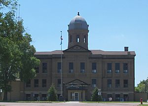
Turner County Courthouse in Parker
|
|

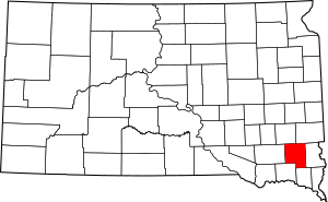
Location within the U.S. state of South Dakota
|
|
 South Dakota's location within the U.S. |
|
| Country | |
| State | |
| Founded | 1871 |
| Named for | John W. Turner |
| Seat | Parker |
| Largest city | Parker |
| Area | |
| • Total | 618 sq mi (1,600 km2) |
| • Land | 617 sq mi (1,600 km2) |
| • Water | 0.6 sq mi (2 km2) 0.1% |
| Population
(2020)
|
|
| • Total | 8,673 |
| • Estimate
(2023)
|
9,027 |
| • Density | 14.034/sq mi (5.419/km2) |
| Time zone | UTC−6 (Central) |
| • Summer (DST) | UTC−5 (CDT) |
| Congressional district | At-large |
Turner County is a special area of land called a county in the state of South Dakota. In 2020, about 8,673 people lived here. The main town, or county seat, is Parker.
Turner County was created in 1871. It was named after John W. Turner, who was an important official in the Dakota Territory back then. This county is also part of the larger Sioux Falls area, which is a big city region.
Contents
Exploring Turner County's Land
Turner County has gently rolling hills. These hills have small valleys and streams that flow through them. Most of the land is used for farming. The county's land slopes down towards the south and east. The highest point is on its western edge, about 1,578 feet (481 meters) above sea level.
The total size of Turner County is about 618 square miles. Almost all of this is land, with only a tiny bit (0.6 square miles) being water.
Main Roads in Turner County
These are the most important roads that help people travel through Turner County:
 U.S. Highway 18
 U.S. Highway 81
 South Dakota Highway 19
 South Dakota Highway 44
 South Dakota Highway 46
- South Dakota Highway 19A
Neighboring Counties
Turner County shares its borders with these other counties:
- Minnehaha County to the northeast
- Lincoln County to the east
- Clay County to the southeast
- Yankton County to the southwest
- Hutchinson County to the west
- McCook County to the northwest
Special Nature Areas
Turner County has a few protected areas. These places help protect wildlife, especially birds like waterfowl.
- Miller Waterfowl Production Area
- Peterson Waterfowl Production Area
- Plucker Waterfowl Production Area
Lakes in Turner County
You can find these lakes in Turner County:
- Mud Lake
- Swan Lake
Who Lives in Turner County?
| Historical population | |||
|---|---|---|---|
| Census | Pop. | %± | |
| 1880 | 5,320 | — | |
| 1890 | 10,256 | 92.8% | |
| 1900 | 13,175 | 28.5% | |
| 1910 | 13,840 | 5.0% | |
| 1920 | 14,871 | 7.4% | |
| 1930 | 14,891 | 0.1% | |
| 1940 | 13,270 | −10.9% | |
| 1950 | 12,100 | −8.8% | |
| 1960 | 11,159 | −7.8% | |
| 1970 | 9,872 | −11.5% | |
| 1980 | 9,255 | −6.2% | |
| 1990 | 8,576 | −7.3% | |
| 2000 | 8,849 | 3.2% | |
| 2010 | 8,347 | −5.7% | |
| 2020 | 8,673 | 3.9% | |
| 2023 (est.) | 9,027 | 8.1% | |
| U.S. Decennial Census 1790-1960 1900-1990 1990-2000 2010-2020 |
|||

Population in 2020
In 2020, the census counted 8,673 people living in Turner County. There were 3,467 households and 2,359 families. This means there were about 14 people living in every square mile.
Population in 2010
Back in 2010, there were 8,347 people. Most people in the county were white (97.5%). Smaller groups included American Indian, Black, and Asian people. About 1.3% of the population was Hispanic or Latino.
Many people in Turner County have German (47.7%) or Norwegian (18.4%) family backgrounds. Other common backgrounds include Danish, Irish, and Dutch.
The average age of people in the county was 43.7 years old. About 29% of households had children under 18 living there. The average household had 2.37 people.
Local Culture and Events
Turner County is home to the oldest county fair in the Dakotas. The very first fair happened a long time ago, from October 13-16, 1880. The main goal of the fair was to show off the great farming achievements in the new county. The fair has moved around over the years. Now, it has been held in its current spot east of Parker for more than 50 years.
Towns and Communities
Turner County has several towns and communities.
Cities
These are the larger towns in the county:
Smaller Towns
These are smaller towns in Turner County:
Special Communities
- Cameron Colony is a census-designated place. This means it's a community that the census counts, but it's not officially a city or town.
Unincorporated Communities
These are small places that are not officially organized as cities or towns:
- Hooker
- Naomi
- Turkey Ridge
Township Areas
Turner County is also divided into smaller areas called townships:
- Brothersfield
- Centerville
- Childstown
- Daneville
- Dolton
- Germantown
- Home
- Hurley
- Marion
- Middleton
- Monroe
- Norway
- Parker
- Rosefield
- Salem
- Spring Valley
- Swan Lake
- Turner
Schools in Turner County
Students in Turner County attend schools in these different school districts:
- Centerville School District 60-1
- Freeman School District 33-1
- Irene-Wakonda School District 13-3
- Lennox School District 41-4
- Marion School District 60-3
- Menno School District 33-2
- Parker School District 60-4
- Viborg Hurley School District 60-6
See also
 In Spanish: Condado de Turner (Dakota del Sur) para niños
 | Janet Taylor Pickett |
 | Synthia Saint James |
 | Howardena Pindell |
 | Faith Ringgold |

