McCook County, South Dakota facts for kids
Quick facts for kids
McCook County
|
|
|---|---|

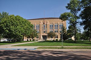
McCook County Courthouse
|
|

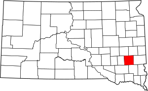
Location within the U.S. state of South Dakota
|
|
 South Dakota's location within the U.S. |
|
| Country | |
| State | |
| Founded | January 8, 1873 (created) June 15, 1878 (organized) |
| Named for | Edwin Stanton McCook |
| Seat | Salem |
| Largest city | Salem |
| Area | |
| • Total | 577 sq mi (1,490 km2) |
| • Land | 574 sq mi (1,490 km2) |
| • Water | 2.7 sq mi (7 km2) 0.5% |
| Population
(2020)
|
|
| • Total | 5,682 |
| • Estimate
(2023)
|
5,809 |
| • Density | 9.847/sq mi (3.802/km2) |
| Time zone | UTC−6 (Central) |
| • Summer (DST) | UTC−5 (CDT) |
| Congressional district | At-large |
McCook County is a place in South Dakota, a state in the United States. It's like a big district or region within the state. In 2020, about 5,682 people lived here. The main town, or "county seat," is Salem.
McCook County was created in 1873 and officially started working in 1878. It got its name from Edwin Stanton McCook, who was a general during the American Civil War and also a governor of the Dakota Territory a long time ago. McCook County is also part of the larger Sioux Falls area.
Contents
Geography of McCook County
McCook County has gentle, rolling hills. Most of the land is used for farming. The land slopes down towards the south and southwest. The highest point in the county is in its northeast corner. It is about 1,798 feet (548 meters) above sea level.
The county covers a total area of 577 square miles (1,494 square kilometers). Most of this area, 574 square miles (1,487 square kilometers), is land. Only a small part, about 2.7 square miles (7 square kilometers), is water.
Main Roads in McCook County
 Interstate 90
 U.S. Highway 81
 South Dakota Highway 38
 South Dakota Highway 42
Neighboring Counties
McCook County shares borders with several other counties.
- Lake County - to the northeast
- Minnehaha County - to the east
- Turner County - to the southeast
- Hutchinson County - to the southwest
- Hanson County - to the west
- Miner County - to the northwest
Parks and Natural Areas
McCook County has several protected areas. These places help to keep nature safe.
- Ediger State Game Production Area
- Forsch Lake State Game Production Area
- Lake Vermillion State Recreation Area
- Lehrman Slough State Game Production Area
- Tschetter Slough State Game Production Area
Lakes in McCook County
You can find a few lakes in the county.
- East Vermillion Lake (also known as Lake Vermillion)
- Island Lake
- Lake Ell
People in McCook County (Demographics)
| Historical population | |||
|---|---|---|---|
| Census | Pop. | %± | |
| 1880 | 1,283 | — | |
| 1890 | 6,448 | 402.6% | |
| 1900 | 8,689 | 34.8% | |
| 1910 | 9,589 | 10.4% | |
| 1920 | 9,990 | 4.2% | |
| 1930 | 10,316 | 3.3% | |
| 1940 | 9,793 | −5.1% | |
| 1950 | 8,828 | −9.9% | |
| 1960 | 8,268 | −6.3% | |
| 1970 | 7,246 | −12.4% | |
| 1980 | 6,444 | −11.1% | |
| 1990 | 5,688 | −11.7% | |
| 2000 | 5,832 | 2.5% | |
| 2010 | 5,618 | −3.7% | |
| 2020 | 5,682 | 1.1% | |
| 2023 (est.) | 5,809 | 3.4% | |
| U.S. Decennial Census 1790-1960 1900-1990 1990-2000 2010-2020 |
|||
Every ten years, the United States counts its population. This is called a census. It helps us understand how many people live in different areas.
2020 Census Information
According to the 2020 United States census, 5,682 people lived in McCook County. There were 2,159 households, which means groups of people living together. About 1,505 of these were families. On average, there were about 9.9 people per square mile. The county also had 2,448 housing units.
2010 Census Information
The 2010 United States census showed that 5,618 people lived in McCook County. There were 2,168 households and 1,535 families. The population density was about 9.8 people per square mile.
Most people in the county were white (98.0%). A small number were American Indian (0.4%), Asian (0.1%), Black (0.1%), or Pacific Islander (0.1%). About 1.8% of the population was of Hispanic or Latino origin.
In 2010, the average age of people in McCook County was 42.7 years old.
Communities in McCook County
McCook County has several towns and smaller communities.
Cities
These are the main cities in the county:
- Bridgewater
- Canistota
- Montrose
- Salem (This is the county seat, where the main government offices are)
- Spencer
Census-Designated Places
These are areas that are like towns but are not officially incorporated as cities.
- Golden View Colony
- Orland Colony
Unincorporated Communities
These are small settlements that are not part of any city or town.
- Stanley Corner
- Unityville
Townships
The county is divided into sixteen smaller areas called townships.
- Benton
- Bridgewater
- Brookfield
- Canistota
- Emery
- Grant
- Greenland
- Jefferson
- Pearl
- Montrose
- Union
- Ramsey
- Richland
- Salem
- Spring Valley
- Sun Prairie
Other Places
- Laurent - (This was a planned housing development that was not completed.)
See also
 In Spanish: Condado de McCook para niños
 | Jackie Robinson |
 | Jack Johnson |
 | Althea Gibson |
 | Arthur Ashe |
 | Muhammad Ali |

