Miner County, South Dakota facts for kids
Quick facts for kids
Miner County
|
|
|---|---|

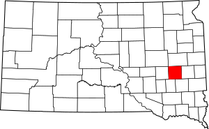
Location within the U.S. state of South Dakota
|
|
 South Dakota's location within the U.S. |
|
| Country | |
| State | |
| Founded | 1873 (created) 1880 (organized) |
| Named for | Nelson Miner and Ephriam Miner |
| Seat | Howard |
| Largest city | Howard |
| Area | |
| • Total | 572 sq mi (1,480 km2) |
| • Land | 570 sq mi (1,500 km2) |
| • Water | 1.6 sq mi (4 km2) 0.3% |
| Population
(2020)
|
|
| • Total | 2,298 |
| • Estimate
(2023)
|
2,280 |
| • Density | 4.017/sq mi (1.5512/km2) |
| Time zone | UTC−6 (Central) |
| • Summer (DST) | UTC−5 (CDT) |
| Congressional district | At-large |
Miner County is a county in the state of South Dakota in the United States. In 2020, about 2,298 people lived here. The main town and county seat is Howard. Miner County was officially created in 1873 and started its government in 1880.
Contents
History of Miner County
Early Trails and Roads
Long ago, the area where Miner County is now was important to the Dakota Sioux. They used trails to connect special places. These places included the pipestone quarries in Minnesota and the Sioux Crossing of the Three Rivers near Fort Thompson. Today, South Dakota Highway 34 follows a path similar to these old trails.
The first road in Dakota Territory was called the Fort Ridgely and South Pass Wagon Road. It was also known as Nobles Trail. This road was built in 1857. It connected Fort Ridgely in Minnesota to South Pass in Wyoming, which was part of the Oregon Trail. Another road, the Minnesota and Powder River Road, also passed through the county in 1865.
How Miner County Was Formed
The borders of Miner County changed several times before they became what they are today. The Dakota Territorial Legislature created the county in 1873. It was named after two important people: Ephriam Miner and Nelson Miner. Both were lawmakers in the territory. Nelson Miner was also a captain in the 1st Dakota Cavalry.
At first, Miner County covered the southern parts of what are now Miner and Sanborn counties. Another county called Bramble County covered the northern parts. In 1879, the legislature combined Miner, Bramble, and parts of Wetmore counties. Bramble and Wetmore counties were then removed. The new Miner County was organized in 1880, and Forestburg became its first county seat.
In 1883, the county was divided again. The western part became Sanborn County. The eastern part kept the name Miner County. Howard was then chosen as the county seat for Miner County.
Railroads and Settlers
In 1881, the Milwaukee Road railroad built tracks through Miner County. These tracks followed the old Fort Ridgely Road from east to west. They connected Madison to Woonsocket. The Chicago and North Western railroad also built tracks in 1882. These tracks crossed the county from Hawarden, Iowa, to Iroquois. However, these railroad tracks are no longer used in the county today.
The first person to settle in Miner County was Matthew A. Moore. He started a homestead near where Howard is now in 1879. Many more settlers arrived between 1879 and 1884. By 1884, all the available government land was claimed. Most of these early settlers came from Norway, Germany, Denmark, Wales, Ireland, and Sweden.
Important Events and Buildings
On August 28, 1884, a photograph of a tornado was taken in Miner County. This was only the second known photograph of a tornado ever taken! You can learn more about it in the article 1884 Howard, South Dakota tornado.
The building where the county government works, the Miner County Courthouse, was built in 1938. It cost about $107,000. This money came from the Public Works Administration, a program during the Great Depression that created jobs. The courthouse was officially opened on September 26, 1938.
On June 13, 1943, a sad event happened over Miner County. Two B-17 bombers, which are large airplanes, crashed during a training exercise. They were from the Sioux City Army Air Base. One plane crashed right away, and the other landed in a creek bed nearby. Eleven airmen lost their lives in this accident.
Geography and Nature
Miner County has rolling hills, which means gentle slopes. You can also see many lakes and ponds. Most of the land is used for farming. The land generally slopes down towards the south and southwest. The highest point in the county is about 1,729 feet (527 meters) above sea level. This high point is in the northeast part of the county, along the northern border.
The county covers a total area of 572 square miles (1,481 square kilometers). Most of this area, 570 square miles (1,476 square kilometers), is land. Only a small part, about 1.6 square miles (4.1 square kilometers), is water.
Main Roads
- U.S. Route 81
- South Dakota Highway 25
- South Dakota Highway 34
Neighboring Counties
Miner County shares its borders with several other counties:
- Kingsbury County to the north
- Lake County to the east
- McCook County to the southeast
- Hanson County to the southwest
- Sanborn County to the west
Natural Areas and Lakes
Miner County has several protected areas where people can go for activities like hunting:
- Bitter Lake Public Shooting Area
- Burke Slough Public Shooting Area
- Morris Lake Public Shooting Area
- Twin Lakes Public Shooting Area
There are also many lakes in the county:
- Bitter Lake
- Glee Lake
- Lake Carthage
- Lake Thompson
- Morris Lake
- Ness Chain Lake
- Stone House Lake
- Twin Lakes
Population and People
Miner County's population has changed over the years. Here's a look at how many people have lived there during different census counts:
| Historical population | |||
|---|---|---|---|
| Census | Pop. | %± | |
| 1880 | 363 | — | |
| 1890 | 5,165 | 1,322.9% | |
| 1900 | 5,864 | 13.5% | |
| 1910 | 7,661 | 30.6% | |
| 1920 | 8,560 | 11.7% | |
| 1930 | 8,376 | −2.1% | |
| 1940 | 6,836 | −18.4% | |
| 1950 | 6,268 | −8.3% | |
| 1960 | 5,398 | −13.9% | |
| 1970 | 4,454 | −17.5% | |
| 1980 | 3,739 | −16.1% | |
| 1990 | 3,272 | −12.5% | |
| 2000 | 2,884 | −11.9% | |
| 2010 | 2,389 | −17.2% | |
| 2020 | 2,298 | −3.8% | |
| 2023 (est.) | 2,280 | −4.6% | |
| U.S. Decennial Census 1790-1960 1900-1990 1990-2000 2010-2020 |
|||
What the 2020 Census Showed
In 2020, the census counted 2,298 people living in Miner County. There were 943 households and 570 families. This means there were about 4 people per square mile. The county also had 1,189 housing units.
What the 2010 Census Showed
In 2010, there were 2,389 people living in Miner County. There were 1,032 households and 606 families. The population density was about 4.2 people per square mile.
Most people in the county were white (97.8%). Smaller groups included Asian (0.4%), American Indian (0.2%), and Black or African American (0.1%). About 1.3% of the population was of Hispanic or Latino origin.
Many residents have German (54.2%) or Norwegian (20.7%) backgrounds. Other ancestries include Irish (12.4%), English (5.7%), and Swedish (5.7%).
The average age of people in Miner County in 2010 was 46.4 years. The average income for a household was about $43,958 per year. For families, the average income was about $54,650. About 8.8% of all people in the county lived below the poverty line. This included 8.2% of those under 18 and 15.4% of those aged 65 or older.
Towns and Communities
Miner County has several towns and communities where people live.
Cities
Towns
Special Places (Census-designated)
These are areas that are like towns but are not officially incorporated as cities or towns.
Unincorporated Community
- Epiphany (partially in Miner County)
Ghost Town
- Argonne (This is a place where a town used to be, but now very few or no people live there.)
See also
 In Spanish: Condado de Miner (Dakota del Sur) para niños
 | Tommie Smith |
 | Simone Manuel |
 | Shani Davis |
 | Simone Biles |
 | Alice Coachman |


