Kingsbury County, South Dakota facts for kids
Quick facts for kids
Kingsbury County
|
|
|---|---|

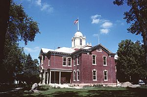
Kingsbury County Courthouse in De Smet
|
|

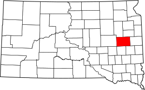
Location within the U.S. state of South Dakota
|
|
 South Dakota's location within the U.S. |
|
| Country | |
| State | |
| Founded | 1873 (created) 1880 (organized) |
| Named for | George W. Kingsbury & T.A. Kingsbury |
| Seat | De Smet |
| Largest city | De Smet |
| Area | |
| • Total | 864 sq mi (2,240 km2) |
| • Land | 832 sq mi (2,150 km2) |
| • Water | 32 sq mi (80 km2) 3.6% |
| Population
(2020)
|
|
| • Total | 5,187 |
| • Estimate
(2023)
|
5,276 |
| • Density | 6.003/sq mi (2.3180/km2) |
| Time zone | UTC−6 (Central) |
| • Summer (DST) | UTC−5 (CDT) |
| Congressional district | At-large |
Kingsbury County is a county in the state of South Dakota. In 2020, about 5,187 people lived here. The main town, or county seat, is De Smet.
The county was first created in 1873 and officially started in 1880. It was named after two brothers, George W. and T. A. Kingsbury. They were important people in the early days of Dakota Territory.
Contents
Geography
Kingsbury County has gentle, rolling hills. In the middle and eastern parts of the county, you'll find many lakes and ponds. Most of the land is used for farming. The highest point in the county is about 1,857 feet (566 meters) above sea level.
The county covers a total area of 864 square miles (2,238 square kilometers). About 832 square miles (2,155 square kilometers) is land, and 3.6 square miles (9.3 square kilometers) is water.
Lakes
Kingsbury County is home to several lakes, including:
- Cherry Lake
- Mud Lake
- Lake Albert
- Lake Badger
- Lake Henry
- Lake Iroquois
- Lake Preston
- Lake Thisted
- Lake Thompson
- Lake Whitewood
- Osceola Lake
- Plum Lake
- Spring Lake
- Spirit Lake
- Twin Lakes (partially)
Main Roads
These are the major highways that run through Kingsbury County:
 U.S. Highway 14
 U.S. Highway 81
 South Dakota Highway 25
Neighboring Counties
Kingsbury County shares its borders with these other counties:
- Hamlin County – to the northeast
- Brookings County – to the east
- Lake County – to the southeast
- Miner County – to the south
- Sanborn County – to the southwest
- Beadle County – to the west
- Clark County – to the northwest
Protected Areas
- Arnold State Public Shooting Area
Population Changes
Over the years, the number of people living in Kingsbury County has changed. Like many farming areas, the population has decreased since its highest point in 1930. This happened as farming became more modern and people moved to bigger cities.
| Historical population | |||
|---|---|---|---|
| Census | Pop. | %± | |
| 1880 | 1,102 | — | |
| 1890 | 8,562 | 677.0% | |
| 1900 | 9,866 | 15.2% | |
| 1910 | 12,560 | 27.3% | |
| 1920 | 12,802 | 1.9% | |
| 1930 | 12,805 | 0.0% | |
| 1940 | 10,831 | −15.4% | |
| 1950 | 9,962 | −8.0% | |
| 1960 | 9,227 | −7.4% | |
| 1970 | 7,657 | −17.0% | |
| 1980 | 6,679 | −12.8% | |
| 1990 | 5,925 | −11.3% | |
| 2000 | 5,815 | −1.9% | |
| 2010 | 5,148 | −11.5% | |
| 2020 | 5,187 | 0.8% | |
| 2023 (est.) | 5,276 | 2.5% | |
| U.S. Decennial Census 1790-1960 1900-1990 1990-2000 2010-2020 |
|||
Recent Population Data
In 2020, the county had 5,187 people living in 2,191 households. The population density was about 6.2 people per square mile. There were 2,615 homes in the county.
In 2010, there were 5,148 people and 2,222 households. The average age of people in the county was about 47 years old.
Communities
Kingsbury County has several towns and communities:
Cities
- De Smet (This is the county seat)
- Arlington (partially in this county)
- Iroquois (partially in this county)
- Lake Preston
- Oldham
Towns
Special Community Areas
- Spring Lake Colony (This is a census-designated place)
Small Unincorporated Communities
Ghost Town
- Manchester (This town no longer exists)
Townships
Townships are smaller areas within a county. Kingsbury County has these townships:
- Badger
- Baker
- De Smet
- Denver
- Esmond
- Hartland
- Iroquois
- Le Sueur
- Manchester
- Mathews
- Spirit Lake
- Spring Lake
- Whitewood
Famous People
Some notable people have connections to Kingsbury County:
- Harvey Dunn - A well-known painter and art teacher.
- Eugene Peter Knudsen - A farmer and politician who served in the Minnesota state legislature.
- Theodore Schultz - An economist who won a Nobel Prize.
- Laura Ingalls Wilder - A famous author, known for her "Little House on the Prairie" books.
See also
 In Spanish: Condado de Kingsbury para niños
 | Jackie Robinson |
 | Jack Johnson |
 | Althea Gibson |
 | Arthur Ashe |
 | Muhammad Ali |

