
Iroquois, South Dakota facts for kids
Quick facts for kids
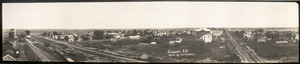
Iroquois, South Dakota
|
|
|---|---|

Location in Beadle County (and Kingsbury County) and the state of South Dakota and the state of South Dakota
|
|
| Country | United States |
| State | South Dakota |
| Counties | Kingsbury, Beadle |
| Incorporated | 1887 |
| Area | |
| • Total | 0.62 sq mi (1.61 km2) |
| • Land | 0.62 sq mi (1.61 km2) |
| • Water | 0.00 sq mi (0.00 km2) |
| Elevation | 1,394 ft (425 m) |
| Population
(2020)
|
|
| • Total | 292 |
| • Density | 470.97/sq mi (181.70/km2) |
| Time zone | UTC-6 (Central (CST)) |
| • Summer (DST) | UTC-5 (CDT) |
| ZIP code |
57353
|
| Area code(s) | 605 |
| FIPS code | 46-32020 |
| GNIS feature ID | 1267438 |
Iroquois is a small city in South Dakota, United States. It sits right on the edge of two counties: Beadle County and Kingsbury County. In 2020, about 292 people lived there.
Interestingly, the local school building, which teaches students from kindergarten to twelfth grade, is in Kingsbury County. But the school's parking lot is actually in Beadle County! A main road, Highway 14, goes directly through Iroquois.
History of Iroquois
Iroquois was first planned out in 1880. The city got its name from the Iroquois people, a group of Native Americans. A post office, where people could send and receive mail, has been open in Iroquois since 1880.
Geography of the City
Iroquois is a small city in terms of size. According to the United States Census Bureau, the city covers a total area of about 0.62 square miles (1.61 square kilometers). All of this area is land, meaning there are no large lakes or rivers within the city limits.
Population and People
The number of people living in Iroquois has changed over the years. Here's how the population has grown and shrunk since 1890:
| Historical population | |||
|---|---|---|---|
| Census | Pop. | %± | |
| 1890 | 181 | — | |
| 1900 | 276 | 52.5% | |
| 1910 | 578 | 109.4% | |
| 1920 | 651 | 12.6% | |
| 1930 | 531 | −18.4% | |
| 1940 | 413 | −22.2% | |
| 1950 | 413 | 0.0% | |
| 1960 | 385 | −6.8% | |
| 1970 | 375 | −2.6% | |
| 1980 | 348 | −7.2% | |
| 1990 | 328 | −5.7% | |
| 2000 | 278 | −15.2% | |
| 2010 | 266 | −4.3% | |
| 2020 | 292 | 9.8% | |
| U.S. Decennial Census | |||
Iroquois in 2010
Let's look at some details from the census taken in 2010. At that time, 266 people lived in Iroquois. These people lived in 119 different homes, and 76 of those homes were families.
The city had about 429 people per square mile (166 people per square kilometer). There were also 135 housing units, which are places where people can live.
Most of the people in Iroquois were White, making up 98.5% of the population. A small number, 1.5%, were from two or more racial backgrounds. About 0.4% of the population identified as Hispanic or Latino.
In the 119 homes, about 25% had children under 18 living there. More than half, 54.6%, were married couples living together. A smaller number of homes had a single parent, either a mother (5%) or a father (4.2%). About 36% of homes were not families.
Almost one-third of all homes (32.8%) had only one person living in them. And 13.5% of homes had someone living alone who was 65 years old or older. On average, each home had 2.24 people, and each family had 2.86 people.
The average age of people in the city was 40.6 years. About 21.8% of residents were under 18 years old. About 6.4% were young adults between 18 and 24. A larger group, 25.9%, were between 25 and 44 years old. The biggest group, 31.2%, were between 45 and 64 years old. Finally, 14.7% were 65 years old or older.
When it came to gender, 52.3% of the people in Iroquois were male, and 47.7% were female.
See also
 In Spanish: Iroquois (Dakota del Sur) para niños
