Hanson County, South Dakota facts for kids
Quick facts for kids
Hanson County
|
|
|---|---|

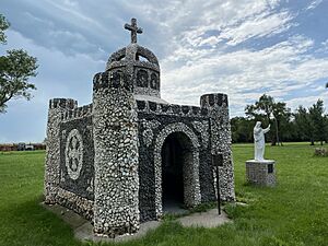
Saint Peter's Grotto is on the National Register of Historic Places
|
|

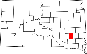
Location within the U.S. state of South Dakota
|
|
 South Dakota's location within the U.S. |
|
| Country | |
| State | |
| Founded | 1871 (created) 1873 (organized) |
| Named for | Joseph R. Hanson |
| Seat | Alexandria |
| Largest city | Alexandria |
| Area | |
| • Total | 434.5 sq mi (1,125 km2) |
| • Land | 435.4 sq mi (1,128 km2) |
| • Water | 0.9 sq mi (2 km2) 0.2% |
| Population
(2020)
|
|
| • Total | 3,461 |
| • Estimate
(2023)
|
3,471 |
| • Density | 7.9655/sq mi (3.0755/km2) |
| Time zone | UTC−6 (Central) |
| • Summer (DST) | UTC−5 (CDT) |
| Congressional district | At-large |
Hanson County is a place in South Dakota, USA. In 2020, about 3,461 people lived here. Its main town, or county seat, is Alexandria. The county was started in 1871 and officially set up in 1873. It's named after Joseph R. Hanson, who was an important person in the first government. Hanson County is part of the larger Mitchell area. It's a bit special because it doesn't have any official airports inside its borders.
Contents
Geography of Hanson County
Hanson County has gentle, rolling hills. Most of the land is used for farming. The James River flows through the western part of the county, heading southeast. The land gently slopes down towards the river on both sides. It generally slopes south.
The county covers about 435 square miles. Most of this area, about 434.5 square miles, is land. Only a small part, about 0.9 square miles, is water. Hanson County is the third smallest county in South Dakota by its total area.
Main Roads
Neighboring Counties
- Miner County - north
- McCook County - east
- Hutchinson County - south
- Davison County - west
- Sanborn County - northwest
People of Hanson County
| Historical population | |||
|---|---|---|---|
| Census | Pop. | %± | |
| 1880 | 1,301 | — | |
| 1890 | 4,267 | 228.0% | |
| 1900 | 4,947 | 15.9% | |
| 1910 | 6,237 | 26.1% | |
| 1920 | 6,202 | −0.6% | |
| 1930 | 6,131 | −1.1% | |
| 1940 | 5,400 | −11.9% | |
| 1950 | 4,896 | −9.3% | |
| 1960 | 4,584 | −6.4% | |
| 1970 | 3,781 | −17.5% | |
| 1980 | 3,415 | −9.7% | |
| 1990 | 2,994 | −12.3% | |
| 2000 | 3,139 | 4.8% | |
| 2010 | 3,331 | 6.1% | |
| 2020 | 3,461 | 3.9% | |
| 2023 (est.) | 3,471 | 4.2% | |
| U.S. Decennial Census 1790-1960 1900-1990 1990-2000 2010-2020 |
|||
The number of people living in Hanson County has changed over many years. In 1880, there were about 1,301 people. The population grew a lot by 1910, reaching over 6,200. Since then, the number of people has slowly gone down. In 2020, about 3,461 people lived in the county.
2020 Population Details
In 2020, there were 3,461 people living in Hanson County. There were 1,146 households, which are groups of people living together. About 855 of these were families. The county had 1,279 housing units, which are places where people can live.
2010 Population Details
In 2010, Hanson County had 3,331 people. There were 1,045 households and 793 families. Most people in the county were white, about 98.6%. A small number of people were Asian or American Indian. About 0.5% of the people were of Hispanic or Latino background.
Many people in Hanson County have German roots, about 63.7%. Other common backgrounds include Irish, English, and Norwegian.
In 2010, about 35% of households had children under 18 living with them. Most households, about 68.8%, were married couples living together. The average age of people in the county was 35.5 years old.
Towns and Communities
Hanson County has several towns and communities where people live.
Cities
- Alexandria (This is the main town, also called the county seat)
- Emery
Towns
Religious Communities
- Millbrook Colony
- Oak Lane Colony
- Rockport Colony
- Rosedale Colony
Other Communities
- Epiphany (This community is partly in Hanson County)
See also
 In Spanish: Condado de Hanson para niños
 | Jessica Watkins |
 | Robert Henry Lawrence Jr. |
 | Mae Jemison |
 | Sian Proctor |
 | Guion Bluford |

