
James River (Dakotas) facts for kids
Quick facts for kids James River |
|
|---|---|

Flowing through Jamestown, North Dakota
|
|

The course and watershed of the James River.
|
|
| Other name(s) | Jim River, Dakota River |
| Country | United States |
| State | North Dakota, South Dakota |
| Cities | Jamestown, ND, Aberdeen, SD, Huron, SD, Mitchell, SD, Yankton, SD |
| Physical characteristics | |
| Main source | Unnamed pond Wells County, North Dakota 1,603 ft (489 m) 47°40′47″N 99°50′55″W / 47.67972°N 99.84861°W |
| River mouth | Missouri River Yankton County, near Yankton, South Dakota 1,152 ft (351 m) 42°52′17″N 97°17′26″W / 42.87139°N 97.29056°W |
| Length | 710 mi (1,140 km) |
| Basin features | |
| Basin size | 20,942 sq mi (54,240 km2) |
The James River, also known as the Jim River or the Dakota River, is a long river in the United States. It flows for about 710 miles (1,140 km). This river is a branch of the much larger Missouri River. It drains a huge area of land, about 20,653 square miles (53,490 km²). Most of this area, about 70 percent, is in South Dakota.
The James River helps drain the flat, low-lying areas of North and South Dakota. These lowlands are found between two higher land areas called the Coteau du Missouri and the Coteau des Prairies. This narrow valley was formed by a giant ice sheet during the last ice age. Because of how it was formed, the James River's path is quite narrow. It also doesn't have many big rivers flowing into it, even though it's very long.
The James River flows downhill very slowly. It drops only about 5 inches for every mile it travels. Because it's so flat, sometimes the river can actually flow backward! This "reverse flow" happens when a lot of water from smaller rivers flows into the James. This extra water can push the James River upstream for several miles. This is most common north of Huron, South Dakota.
| Top - 0-9 A B C D E F G H I J K L M N O P Q R S T U V W X Y Z |
The River's Journey
The James River starts in Wells County, North Dakota. It begins near a small pond about 10 miles (16 km) northwest of Fessenden. It first flows east for a short distance towards New Rockford. Then, it generally flows south-southeast through eastern North Dakota.
It passes by Jamestown. Here, a large dam creates a reservoir called the Jamestown Dam. After the dam, the Pipestem River joins the James River.
The river then enters northeastern South Dakota in Brown County. Here, it is dammed again to form two more reservoirs. These are located northeast of Aberdeen.
At Columbia, another river called the Elm River flows into the James. The James River continues flowing southward across eastern South Dakota. It passes through Huron and Mitchell. In Mitchell, it is joined by Firesteel Creek. South of Mitchell, it flows southeast. Finally, it joins the Missouri River just east of Yankton.
The James River is special because it flows completely across the state of South Dakota. The only other river to do this is the Missouri River itself.
River Conditions
During normal years, the James River and its smaller branches can have very still water. But they can also experience floods. Floods often happen after snow melts or after heavy rains. The James River has low banks, so water can easily overflow them. When this happens, floods can cover a large part of the flat land next to the river. When the river water is still and not flowing much, its quality can sometimes drop.
History of the James River

The Dakota people, who lived in this area long ago, called the river "E-ta-zi-po-ka-se Wakpa." This name means "unnavigable river," because it was often hard to travel on by boat.
Later, French explorers arrived and named the river Rivière aux Jacques. This means "James River" in English. By the time Dakota Territory was officially formed, people were already calling it the James River.
A man named Thomas L. Rosser helped build the Northern Pacific Railroad across North Dakota. He was from Virginia and named the town of Jamestown, North Dakota, after the old English colony of Jamestown, Virginia.
In 1861, a law called the Dakota Territory Organic Act tried to rename the river the Dakota River. However, this new name was not popular. People kept using the older name, and so the river is still known as the James River today.
Images for kids
-
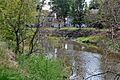
Flowing through Jamestown, North Dakota
-
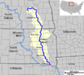
The course and watershed of the James River.
-
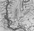
This old map from 1814 shows the James River (called "Jacque") in the left-center area.
See also
 In Spanish: Río James (Dakotas) para niños
