
Brown County, South Dakota facts for kids
Quick facts for kids
Brown County
|
||
|---|---|---|
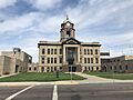
.jpg)
Brown County Courthouse in fall
|
||
|
||

Location within the U.S. state of South Dakota
|
||
 South Dakota's location within the U.S. |
||
| Country | ||
| State | ||
| Founded | July 6, 1881 | |
| Seat | Aberdeen | |
| Largest city | Aberdeen | |
| Area | ||
| • Total | 1,731 sq mi (4,480 km2) | |
| • Land | 1,713 sq mi (4,440 km2) | |
| • Water | 18 sq mi (50 km2) 1.0% | |
| Population
(2020)
|
||
| • Total | 38,301 | |
| • Estimate
(2023)
|
37,733 |
|
| • Density | 22.127/sq mi (8.5431/km2) | |
| Time zone | UTC−6 (Central) | |
| • Summer (DST) | UTC−5 (CDT) | |
| Congressional district | At-large | |

Brown County is a county located in the state of South Dakota in the United States. It was founded on July 6, 1881.
As of the 2020 census, about 38,301 people lived here. This makes it the fourth most populated county in South Dakota. The main city and county seat (where the county government is) is Aberdeen.
The county is named after Alfred Brown. He was a legislator (someone who makes laws) in the Dakota Territory back in 1879. Brown County is also part of the Aberdeen, SD Micropolitan Statistical Area. This means it's connected to Aberdeen for jobs and daily life.
Contents
Exploring Brown County
Where is Brown County?
Brown County is in the northern part of South Dakota. Its northern border touches the state of North Dakota. The James River flows through the county, heading south.
The land in Brown County is mostly rolling hills. It slopes gently to the south and east. A lot of the land is used for farming.
The county covers a total area of about 1,731 square miles (4,483 square kilometers). Most of this is land, with only a small part being water.
Main Roads to Know
You can get around Brown County using these important highways:
 U.S. Highway 12
 U.S. Highway 281
 South Dakota Highway 10
 South Dakota Highway 37
Neighboring Counties
Brown County shares its borders with several other counties:
- Dickey County, North Dakota - to the north
- Sargent County, North Dakota - to the northeast
- Marshall County - to the east
- Day County - to the southeast
- Spink County - to the south
- Faulk County - to the southwest
- Edmunds County - to the southwest
- McPherson County - to the northwest
Natural Places to Visit
Brown County has many protected natural areas. These places help keep nature safe and offer outdoor fun. Some of these areas include:
- Bodi State Game Production Area
- Casanova State Game Production Area
- Richmond Lake State Recreation Area
- Sand Lake National Wildlife Refuge
People of Brown County
| Historical population | |||
|---|---|---|---|
| Census | Pop. | %± | |
| 1880 | 353 | — | |
| 1890 | 16,855 | 4,674.8% | |
| 1900 | 15,286 | −9.3% | |
| 1910 | 25,867 | 69.2% | |
| 1920 | 29,509 | 14.1% | |
| 1930 | 31,458 | 6.6% | |
| 1940 | 29,676 | −5.7% | |
| 1950 | 32,617 | 9.9% | |
| 1960 | 34,106 | 4.6% | |
| 1970 | 36,920 | 8.3% | |
| 1980 | 36,962 | 0.1% | |
| 1990 | 35,580 | −3.7% | |
| 2000 | 35,460 | −0.3% | |
| 2010 | 36,531 | 3.0% | |
| 2020 | 38,301 | 4.8% | |
| 2023 (est.) | 37,733 | 3.3% | |
| US Decennial Census 1790-1960 1900-1990 1990-2000 2010-2020 |
|||
Population Facts
In 2020, there were 38,301 people living in Brown County. There were also 16,130 households. A household is a group of people living together in one home.
The population density was about 22.4 people per square mile. This tells us how many people live in a certain area.
Most people in the county are white (about 93.2% in 2010). There are also American Indian, Asian, and Black residents. About 1.4% of the population is of Hispanic or Latino background.
The average age of people in Brown County in 2010 was 38.6 years old.
Cities and Towns
Brown County has several cities and smaller towns where people live.
Cities
Towns
Other Communities
There are also smaller communities in Brown County. Some of these are called "Census-designated places" (CDPs). These are areas that look like towns but are not officially incorporated as cities or towns.
Townships
Brown County is also divided into smaller areas called townships. These help with local government and services. Some of these include:
- Aberdeen
- Allison
- Bates
- Bath
- Barnard
- Cambria
- Carlisle
- Claremont
- Columbia
- East Hanson
- East Rondell
- Franklyn
- Frederick
- Garden Prairie
- Garland
- Gem
- Greenfield
- Groton
- Hecla
- Henry
- Highland
- Lansing
- Liberty
- Lincoln
- Mercier
- New Hope
- North Detroit
- Oneota
- Ordway
- Osceola
- Palmyra
- Portage
- Prairiewood
- Putney
- Ravinia
- Richland
- Riverside
- Savo
- Shelby
- South Detroit
- Warner
- West Hanson
- West
- Westport
Images for kids
-
Brown County Courthouse in fall
See also
 In Spanish: Condado de Brown (Dakota del Sur) para niños
