
Dickey County, North Dakota facts for kids
Quick facts for kids
Dickey County
|
|
|---|---|
.jpg)
Postcard. Dickey County Courthouse in 1915.
|
|

Location within the U.S. state of North Dakota
|
|
 North Dakota's location within the U.S. |
|
| Country | |
| State | |
| Founded | March 5, 1881 (created) August 18, 1882 (organized) |
| Named for | George H. Dickey |
| Seat | Ellendale |
| Largest city | Oakes |
| Area | |
| • Total | 1,142 sq mi (2,960 km2) |
| • Land | 1,131 sq mi (2,930 km2) |
| • Water | 11 sq mi (30 km2) 0.9% |
| Population
(2020)
|
|
| • Total | 4,999 |
| • Estimate
(2022)
|
4,923 |
| • Density | 4.3774/sq mi (1.6901/km2) |
| Time zone | UTC−6 (Central) |
| • Summer (DST) | UTC−5 (CDT) |
| Congressional district | At-large |
Dickey County is a county located in the state of North Dakota in the United States. It is like a special area within the state. As of the 2020 count, about 4,999 people live there. The main town, or county seat, where the county government is located, is Ellendale.
Contents
History of Dickey County
Dickey County was created a long time ago. The government of the Dakota Territory decided to form it on March 5, 1881. It was made from parts of other areas. The county officially started its own government on August 18, 1882. It was named after George H. Dickey, who was a member of the local government at that time.
Geography and Nature
Dickey County is located in the southern part of North Dakota. Its southern border touches the state of South Dakota. Two important rivers flow through the county. The James River goes through the eastern part. The Maple River flows through the middle.
The land in the county has rolling hills. You can find many lakes and ponds in the western part. Most of the land is used for farming. The highest point in the county is a hill near the southwest corner. It is about 2,139 feet (652 meters) above sea level. The county covers a total area of 1,142 square miles (2,958 square kilometers). Most of this is land, with a small part being water.
Main Roads
These are the most important roads that go through Dickey County:
 U.S. Highway 281
 North Dakota Highway 1
 North Dakota Highway 11
 North Dakota Highway 56
Neighboring Counties
Dickey County shares its borders with these other counties:
- LaMoure County to the north
- Ransom County to the northeast
- Sargent County to the east
- Brown County, South Dakota to the south
- McPherson County, South Dakota to the southwest
- McIntosh County to the west
Protected Natural Areas
Dickey County is home to two special areas that protect wildlife:
Lakes in Dickey County
You can find these lakes in the county:
- Hilles Lake
- Pheasant Lake
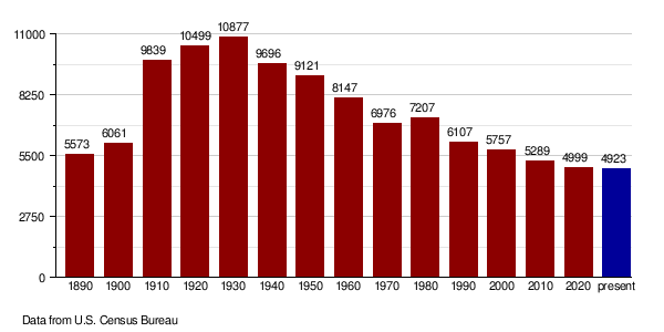
People and Population
The number of people living in Dickey County has changed over the years. Here's how the population has grown and shrunk:
| Historical population | |||
|---|---|---|---|
| Census | Pop. | %± | |
| 1890 | 5,573 | — | |
| 1900 | 6,061 | 8.8% | |
| 1910 | 9,839 | 62.3% | |
| 1920 | 10,499 | 6.7% | |
| 1930 | 10,877 | 3.6% | |
| 1940 | 9,696 | −10.9% | |
| 1950 | 9,121 | −5.9% | |
| 1960 | 8,147 | −10.7% | |
| 1970 | 6,976 | −14.4% | |
| 1980 | 7,207 | 3.3% | |
| 1990 | 6,107 | −15.3% | |
| 2000 | 5,757 | −5.7% | |
| 2010 | 5,289 | −8.1% | |
| 2020 | 4,999 | −5.5% | |
| 2022 (est.) | 4,923 | −6.9% | |
| U.S. Decennial Census 1790-1960 1900-1990 1990-2000 2010-2020 |
|||
Recent Population Counts
In 2020, the official count showed 4,999 people living in Dickey County. In 2010, there were 5,289 people. These people lived in 2,180 homes. About 56% of these homes were married couples. The average age of people in the county was 43 years old.
Population Changes Over Time
This chart shows how the number of people in Dickey County has changed from 1890 until today. You can see when the population grew and when it became smaller.
Towns and Villages
Cities in Dickey County
These are the main cities you can find in Dickey County:
Smaller Communities
These are smaller places in the county that are not officially cities:
- Glover
- Guelph
- Keystone
- Silverleaf
- Wirch
Past Communities
- Merricourt was once a community in Dickey County, but it is no longer active.
See also
 In Spanish: Condado de Dickey para niños
