
Sargent County, North Dakota facts for kids
Quick facts for kids
Sargent County
|
|
|---|---|

|
|

Location within the U.S. state of North Dakota
|
|
 North Dakota's location within the U.S. |
|
| Country | |
| State | |
| Founded | April 9, 1883 (created) October 8, 1883 (organized) |
| Named for | H. E. Sargent |
| Seat | Forman |
| Largest city | Gwinner |
| Area | |
| • Total | 867 sq mi (2,250 km2) |
| • Land | 859 sq mi (2,220 km2) |
| • Water | 8.4 sq mi (22 km2) 1.0% |
| Population
(2020)
|
|
| • Total | 3,862 |
| • Estimate
(2022)
|
3,795 |
| • Density | 4.4544/sq mi (1.7199/km2) |
| Time zone | UTC−6 (Central) |
| • Summer (DST) | UTC−5 (CDT) |
| Congressional district | At-large |
Sargent County is a county located in the state of North Dakota in the United States. Its main town, where the county government is located, is Forman. The biggest city in the county is Gwinner.
The county is named after Homer E. Sargent. He was a general manager for the Northern Pacific Railroad Company a long time ago. Sargent County is a farming area in southeastern North Dakota. It has many small lakes, ponds, and hills. It sits between the James River and Red River valleys.
In 2020, about 3,862 people lived here. It is the 29th largest county in North Dakota by population. This county was also the first home of the Bobcat Company. This company makes farm and construction machines. They still build many skid-steer loaders at their factory in Gwinner.
Contents
A Look Back: History of Sargent County
Sargent County was created on April 9, 1883, by the Dakota Territory. Some parts came from Ransom County. Other parts were new areas or from Native American reserves. The county was named after H. E. Sargent, a railroad boss.
At first, the county didn't have its own full government. It was linked to Richland County for court matters. It was also linked to Ransom County for other government tasks. But this changed quickly! On October 8, 1883, Sargent County got its own government. Milnor was chosen as the first county seat. However, in 1884, during the county's first election, Forman became the new county seat.
The Northern Pacific Railway built a train line into the county in 1883. It reached Milnor. By 1900, the train line went all the way across the county. More and more people moved to Sargent County. The population grew a lot, reaching its highest point in 1920 with 9,655 people.
The Sargent County Courthouse is a beautiful building. It was built in 1910 in a style called Beaux Arts. This building is so important that it is listed on the U.S. National Register of Historic Places.
Exploring Sargent County's Land and Lakes
Sargent County is in the southeastern part of North Dakota. It shares a border with South Dakota to the south. The county is shaped almost like a perfect rectangle. It has a small bump in its southeastern corner. This bump helps it line up with the Lake Traverse Indian Reservation.
The county covers about 867 square miles in total. Most of this area, about 859 square miles, is land. The rest, about 8.4 square miles, is water. That's about 1% water!
Most of the county's water flows into the Wild Rice River. This river starts near Brampton in the southwestern part of the county. It flows east through the southern part of the county. It passes through Silver Lake and Lake Tewaukon. Then it continues east into Richland County. Small parts of the county in the west and north are in the James River and Sheyenne River areas.
The land in Sargent County changes a lot. The southern and western parts have many hills. These include the northern tip of the Coteau des Prairies. This is a high area along the county's southern border. As you move east, the land becomes much flatter. This flatter area is part of the Red River Valley.
The flat areas are mostly used for growing crops. Farmers grow corn, soybeans, and wheat here. The hillier parts are often used as pastures for animals like cows. The land generally slopes down towards the south and east. The highest point is about 1,365 feet above sea level on the western border. However, a rise on the eastern part of the southern border reaches about 1,729 feet.
Sargent County is in the Prairie Pothole Region. This means it has many wetlands, which are like marshy areas. Most of these are shallow ponds called sloughs. Their size changes depending on how much rain there is. But there are also several bigger, deeper lakes. Lake Tewaukon is one of the largest. It is inside the Tewaukon National Wildlife Refuge. In the western part of the county, there is a chain of lakes. The biggest of these is Kraft Lake. Many of the county's lakes have fish like yellow perch and walleye. This makes fishing a popular activity. People even go ice fishing in the winter!
Neighbors: Counties Around Sargent
- Ransom County (north)
- Richland County (east)
- Roberts County, South Dakota (southeast)
- Marshall County, South Dakota (south)
- Brown County, South Dakota (southwest)
- Dickey County (west)
Special Nature Spots: Protected Areas
- Storm Lake National Wildlife Refuge
- Tewaukon National Wildlife Refuge
- Wild Rice Lake National Wildlife Refuge
Water Wonders: Lakes of Sargent County
- Alkali Lake
- Borg Lake
- Buffalo Lake
- Clouds Lake
- Golden Hill Lake
- Kraft Lake
- Lake Dell
- Lake Fedge
- Lake Tewaukon
- Pickell Lake
- Silver Lake
- Sprague Lake
- Storm Lake
- White Lake
Who Lives Here? Sargent County's People
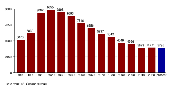
| Historical population | |||
|---|---|---|---|
| Census | Pop. | %± | |
| 1890 | 5,076 | — | |
| 1900 | 6,039 | 19.0% | |
| 1910 | 9,202 | 52.4% | |
| 1920 | 9,655 | 4.9% | |
| 1930 | 9,298 | −3.7% | |
| 1940 | 8,693 | −6.5% | |
| 1950 | 7,616 | −12.4% | |
| 1960 | 6,856 | −10.0% | |
| 1970 | 5,937 | −13.4% | |
| 1980 | 5,512 | −7.2% | |
| 1990 | 4,549 | −17.5% | |
| 2000 | 4,366 | −4.0% | |
| 2010 | 3,829 | −12.3% | |
| 2020 | 3,862 | 0.9% | |
| 2022 (est.) | 3,795 | −0.9% | |
| U.S. Decennial Census 1790–1960 1900–1990 1990–2000 2010–2020 |
|||
Quick Facts: 2020 Census
In 2020, the official count showed that 3,862 people lived in Sargent County.
More Details: 2010 Census
The 2010 census counted 3,829 people living in 1,675 households. A household is a group of people living in one home. There were 1,113 families. The population density was about 4.46 people for every square mile.
Most people in the county were white (98.0%). A small number were American Indian (0.5%), Asian (0.2%), or other groups. About 1.3% of the people were of Hispanic or Latino background.
When it came to family history, many people had German roots (51.3%). Others had Norwegian (35.9%), Swedish (11.8%), or Irish (8.4%) backgrounds.
About 27.1% of households had children under 18 living there. More than half (57.3%) were married couples. The average household had 2.26 people. The average family had 2.79 people. The average age of people in the county was 45.9 years old.
The average income for a household was $49,318 per year. For a family, it was $59,531. About 7.8% of all people in the county lived below the poverty line. This included 10.5% of kids under 18 and 10.4% of people aged 65 or older.
Growing and Changing: Population Over Time
Getting Around: Roads and Highways
These are the main roads that help people travel through Sargent County:
 North Dakota Highway 11
 North Dakota Highway 13
 North Dakota Highway 32
Towns and Areas in Sargent County
Main Towns: Cities
Special Areas: Census-Designated Place
Smaller Spots: Unincorporated Communities
These are smaller places that are not officially cities or towns.
- Cogswell
- Crete
- Stirum
- Straubville
Local Divisions: Townships
Counties are often divided into smaller areas called townships. Here are the townships in Sargent County:
- Bowen
- Brampton
- Denver
- Dunbar
- Forman
- Hall
- Harlem
- Herman
- Jackson
- Kingston
- Marboe
- Milnor
- Ransom
- Rutland
- Sargent
- Shuman
- Southwest
- Taylor
- Tewaukon
- Verner
- Vivian
- Weber
- Whitestone Hill
- Willey
Images for kids
-
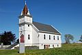
The former Brampton Lutheran Church, moved to Norway in 1997
-
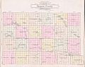
Outline map of Sargent County, North Dakota, 1909


See also
 In Spanish: Condado de Sargent para niños
