
Richland County, North Dakota facts for kids
Quick facts for kids
Richland County
|
|
|---|---|

Richland County Courthouse in Wahpeton
|
|

Location within the U.S. state of North Dakota
|
|
 North Dakota's location within the U.S. |
|
| Country | |
| State | |
| Founded | January 4, 1873 (created) November 25, 1873 (organized) |
| Named for | Morgan T. Rich |
| Seat | Wahpeton |
| Largest city | Wahpeton |
| Area | |
| • Total | 1,445 sq mi (3,740 km2) |
| • Land | 1,436 sq mi (3,720 km2) |
| • Water | 9.7 sq mi (25 km2) 0.7% |
| Population
(2020)
|
|
| • Total | 16,529 |
| • Estimate
(2023)
|
16,558 |
| • Density | 11.439/sq mi (4.4165/km2) |
| Time zone | UTC−6 (Central) |
| • Summer (DST) | UTC−5 (CDT) |
| Congressional district | At-large |
Richland County is a special area called a county located in the southeastern part of North Dakota. It's a state in the United States. In 2020, about 16,529 people lived here. The main town and center of the county is Wahpeton.
Richland County is part of a larger area called the Wahpeton, ND–MN Micropolitan Statistical Area. This means it's connected to nearby towns and cities for things like jobs and services. It's also part of the even bigger Fargo-Wahpeton, ND-MN Combined Statistical Area.
Contents
History of Richland County
The area that is now Richland County was officially created on January 4, 1873. This happened when the government of the Dakota Territory decided to set aside this land. It was named after Morgan T. Rich, who was one of the first people to settle in the area where Wahpeton is today.
The county was fully organized on November 25, 1873. This means it started to have its own local government. The county's borders changed a couple of times in 1883 and 1885. Since 1885, the county's shape and size have stayed the same.
In 2022, Richland County experienced very strong winds, over 70 miles per hour. This type of storm is called a derecho. It caused 34 tornadoes in the region, and one of them passed near LeMars in Richland County.

Geography and Nature
Richland County is in the very southeast corner of North Dakota. It shares a border with Minnesota to the east, across the Red River. To the south, it borders South Dakota.
The Red River flows north along the eastern edge of the county. It eventually empties into the Hudson Bay. Other rivers like the Wild Rice River and the Sheyenne River also flow through the county. They both join the Red River further north.
Most of Richland County is flat. However, there are some gently rolling hills in the southwest and northwest parts. A lot of the land is used for farming. The land generally slopes downwards towards the north and east. The highest point in the county is about 1,220 feet (372 meters) above sea level.
The county covers a total area of about 1,445 square miles (3,743 square kilometers). Most of this is land, about 1,436 square miles (3,719 square kilometers). Only a small part, about 9.7 square miles (25 square kilometers), is water.
Main Roads in Richland County
 Interstate 29
 US 81
US 81 North Dakota Highway 11
 North Dakota Highway 13
 North Dakota Highway 18
 North Dakota Highway 27
 North Dakota Highway 46
 North Dakota Highway 127
Neighboring Counties
Richland County shares its borders with several other counties:
- Cass County - to the north
- Clay County, Minnesota - to the northeast
- Wilkin County, Minnesota - to the east
- Traverse County, Minnesota - to the southeast
- Roberts County, South Dakota - to the south
- Marshall County, South Dakota - to the southwest
- Sargent County - to the west
- Ransom County - to the northwest
Protected Natural Areas
Part of the Sheyenne National Grassland is located within Richland County. This is a special area managed to protect natural resources.
Lakes in Richland County
- Bisek Lake
- Grass Lake
- Gullys Slough
- Kreiser Lake
- Lueck Lake
- Moran Lake
- Park Lake
- Silver Lake
- Stacks Slough
- Swan Lake
- Willows Pond
People and Population
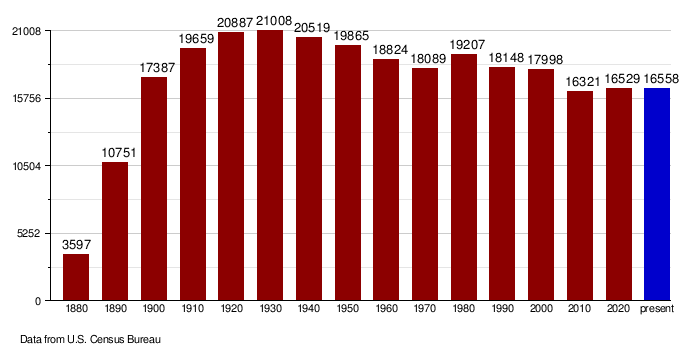
| Historical population | |||
|---|---|---|---|
| Census | Pop. | %± | |
| 1880 | 3,597 | — | |
| 1890 | 10,751 | 198.9% | |
| 1900 | 17,387 | 61.7% | |
| 1910 | 19,659 | 13.1% | |
| 1920 | 20,887 | 6.2% | |
| 1930 | 21,008 | 0.6% | |
| 1940 | 20,519 | −2.3% | |
| 1950 | 19,865 | −3.2% | |
| 1960 | 18,824 | −5.2% | |
| 1970 | 18,089 | −3.9% | |
| 1980 | 19,207 | 6.2% | |
| 1990 | 18,148 | −5.5% | |
| 2000 | 17,998 | −0.8% | |
| 2010 | 16,321 | −9.3% | |
| 2020 | 16,529 | 1.3% | |
| 2023 (est.) | 16,558 | 1.5% | |
| U.S. Decennial Census 1790-1960 1900-1990 1990-2000 2010-2020 |
|||
The population of Richland County has changed over the years. In 2020, the census counted 16,529 people living there. There were 6,710 households, which are groups of people living together.
In 2010, the census showed 16,321 people. Most people were white (95.0%). Other groups included American Indian (2.0%), Black or African American (0.7%), and Asian (0.5%). About 1.7% of the people were of Hispanic or Latino background.
Many people in Richland County have German (53.0%) or Norwegian (31.2%) family backgrounds. The average age of people in the county was about 39.4 years old.
The average income for a household in 2010 was $47,131 per year. For families, it was $64,636. About 10.7% of the people in the county lived below the poverty line.
How the Population Has Changed Over Time
Towns and Communities
Richland County has several towns and smaller communities where people live.
Cities in Richland County
- Abercrombie
- Barney
- Christine
- Colfax
- Dwight
- Fairmount
- Great Bend
- Hankinson
- Lidgerwood
- Mantador
- Mooreton
- Wahpeton (This is the main town and county seat!)
- Walcott
- Wyndmere
Smaller Communities (Unincorporated)
These are places where people live, but they don't have their own city government.
- Blackmer
- Enloe
- Galchutt
- La Mars
- Lithia
- Tyler
Education in Richland County
Students in Richland County attend schools in various school districts.
- Fairmount Public School District 18
- Hankinson Public School District 8
- Kindred Public School District 2
- Lidgerwood Public School District 28
- Richland Public School District 44
- Wahpeton Public School District 37
- Wyndmere Public School District 42
There is also a special school called Circle of Nations Wahpeton Indian School. This school is managed by Native American tribes and works with the Bureau of Indian Education.
Images for kids
-
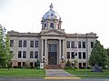
Richland County Courthouse in Wahpeton
See also
 In Spanish: Condado de Richland (Dakota del Norte) para niños
