
Cass County, North Dakota facts for kids
Quick facts for kids
Cass County
|
|
|---|---|

Cass County Courthouse in Fargo
|
|

Location within the U.S. state of North Dakota
|
|
 North Dakota's location within the U.S. |
|
| Country | |
| State | |
| Founded | October 27, 1873 |
| Named for | George Washington Cass |
| Seat | Fargo |
| Largest city | Fargo |
| Area | |
| • Total | 1,767.811 sq mi (4,578.61 km2) |
| • Land | 1,764.935 sq mi (4,571.16 km2) |
| • Water | 2.876 sq mi (7.45 km2) 0.2%% |
| Population
(2020)
|
|
| • Total | 184,525 |
| • Estimate
(2023)
|
196,362 |
| • Density | 111.266/sq mi (42.960/km2) |
| Time zone | UTC−6 (Central) |
| • Summer (DST) | UTC−5 (CDT) |
| Congressional district | At-large |
Cass County is a county in the state of North Dakota. It is located in the United States. As of 2020, about 184,525 people lived there.
Cass County is the most populated county in North Dakota. It has almost a quarter of the state's total population. The main city, or county seat, is Fargo. Fargo is also the biggest city in North Dakota.
The county is named after George Washington Cass. He was the president of the Northern Pacific Railway from 1872 to 1875. This is the only Cass County in the U.S. that is not named after Lewis Cass. Cass County is part of the larger Fargo, ND-Moorhead, MN Metropolitan Statistical Area. This area includes nearby cities in both North Dakota and Minnesota.
Contents
History of Cass County
Cass County was officially created on January 4, 1873. This happened by a decision of the Dakota Territory government. The county officially started on October 27 of that same year. It was named after George Washington Cass, who was an important railroad leader. The county's borders have changed a few times since then, in 1875 and again in 1961.
Geography of Cass County
Cass County is located on the eastern side of North Dakota. Its eastern border is right next to the state of Minnesota. The Red River flows north along this eastern border. This river eventually goes to Lake Winnipeg and Hudson Bay.
The land in Cass County has gentle, rolling hills. Most of the land is used for farming. The land slopes down towards the north and east. The highest point in the county is in the southwest corner. It is about 1,194 feet (364 meters) above sea level.
The county covers a total area of about 1,767.811 square miles (4,578.60 km²). Most of this is land, about 1,764.935 square miles (4,571.16 km²). A small part, about 2.876 square miles (7.45 km²), is water. This means only about 0.2% of the county's area is water.
Main Roads
Many important roads pass through Cass County. These roads help people travel and transport goods.
 Interstate 29
 Interstate 94
 U.S. Highway 10
 U.S. Highway 52
 U.S. Highway 81
 North Dakota Highway 10
 North Dakota Highway 18
 North Dakota Highway 38
 North Dakota Highway 46
 North Dakota Highway 294
Public Transportation
Cass County has several ways for people to get around.
- Amtrak Empire Builder (train service with a stop at Fargo station)
- Jefferson Lines (bus service)
- MATBUS (local bus service in the Fargo-Moorhead area)
Neighboring Counties
Cass County shares its borders with several other counties.
- Traill County - to the north
- Norman County, Minnesota - to the northeast
- Clay County, Minnesota - to the east
- Richland County - to the southeast
- Ransom County - to the southwest
- Barnes County - to the west
- Steele County - to the northwest
Lakes in Cass County
Cass County has a few lakes within its borders.
- Brewer Lake
- Lake Bertha
People of Cass County (Demographics)
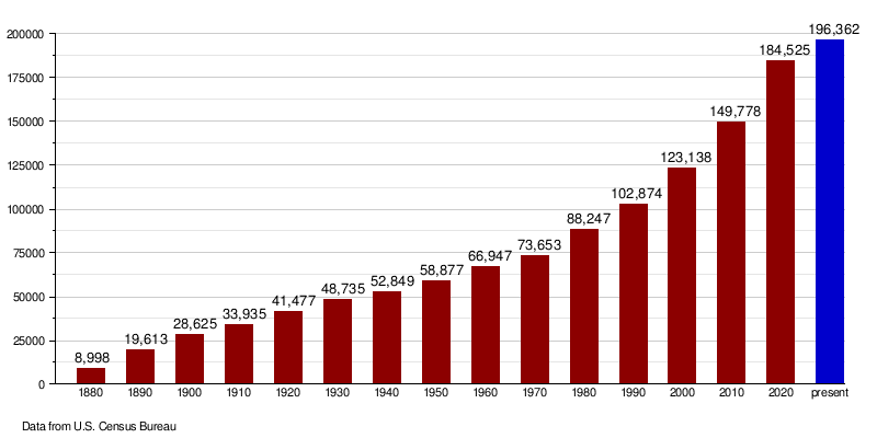
| Historical population | |||
|---|---|---|---|
| Census | Pop. | %± | |
| 1880 | 8,998 | — | |
| 1890 | 19,613 | 118.0% | |
| 1900 | 28,625 | 45.9% | |
| 1910 | 33,935 | 18.6% | |
| 1920 | 41,477 | 22.2% | |
| 1930 | 48,735 | 17.5% | |
| 1940 | 52,849 | 8.4% | |
| 1950 | 58,877 | 11.4% | |
| 1960 | 66,947 | 13.7% | |
| 1970 | 73,653 | 10.0% | |
| 1980 | 88,247 | 19.8% | |
| 1990 | 102,874 | 16.6% | |
| 2000 | 123,138 | 19.7% | |
| 2010 | 149,778 | 21.6% | |
| 2020 | 184,525 | 23.2% | |
| 2023 (est.) | 196,362 | 31.1% | |
| U.S. Decennial Census 1790-1960 1900-1990 1990-2000 2010-2020 |
|||
In early 2024, the average value of a home in Cass County was about $309,530. This was a small increase from the year before.
In 2023, there were about 84,603 homes in Cass County. Each home had about 2.24 people living in it. The average income for a household was around $73,742. About 9.9% of the people in the county lived below the poverty line.
About 75.2% of the people in Cass County had jobs. A large number, 43.4%, had a college degree or higher. Most adults, 96.4%, had at least a high school diploma. The average age of people in the county was 32.6 years old.
Population Changes Over Time
The population of Cass County has grown a lot over the years.
Communities in Cass County
Cass County has many different towns and cities. These are places where people live and work.
Cities
Census-Designated Places (CDPs)
These are areas that are like towns but are not officially incorporated as cities.
Unincorporated Communities
These are smaller communities that do not have their own local government.
Education in Cass County
Cass County has several school districts. These districts provide education for students from kindergarten through 12th grade.
K-12 School Districts
- Central Cass Public School District 17
- Enderlin Area Public School District 24
- Fargo Public Schools
- Hope-Page Public Schools
- Kindred Public School District 2
- Maple Valley Public School District
- May-Port CG Public School District 14
- Northern Cass Public School District 97
- West Fargo Public Schools
Elementary School Districts
- Mapleton Public School District 7
See also
 In Spanish: Condado de Cass (Dakota del Norte) para niños
