Clay County, Minnesota facts for kids
Quick facts for kids
Clay County
|
|
|---|---|

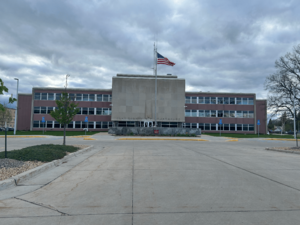
Clay County Courthouse
|
|

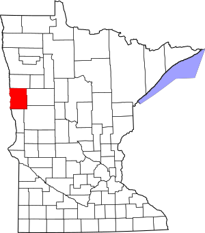
Location within the U.S. state of Minnesota
|
|
 Minnesota's location within the U.S. |
|
| Country | |
| State | |
| Founded | March 8, 1862 (created) 1872 (organized) |
| Named for | Henry Clay |
| Seat | Moorhead |
| Largest city | Moorhead |
| Area | |
| • Total | 1,053 sq mi (2,730 km2) |
| • Land | 1,045 sq mi (2,710 km2) |
| • Water | 7.3 sq mi (19 km2) 0.7%% |
| Population
(2020)
|
|
| • Total | 65,318 |
| • Estimate
(2023)
|
66,258 |
| • Density | 62.030/sq mi (23.950/km2) |
| Time zone | UTC−6 (Central) |
| • Summer (DST) | UTC−5 (CDT) |
| Congressional district | 7th |
Clay County is a county in the state of Minnesota. It's like a big neighborhood or district. In 2020, about 65,318 people lived here. The main city and government center is Moorhead. Clay County is also part of a larger area called the Fargo-Moorhead Metropolitan Area, which includes parts of North Dakota.
Contents
History of Clay County
Clay County was first created in 1860. It was originally named Breckinridge County. This name honored John C. Breckinridge, who was the Vice President of the United States.
However, when the Civil War began, John C. Breckinridge joined the Confederate Army. So, in March 1862, the state government changed the county's name. They renamed it after Henry Clay. Henry Clay (1777–1852) was a famous politician from Kentucky, just like Breckinridge.
Henry Clay was known as "The Great Pacificator" or "The Great Compromiser." He worked hard to prevent the Civil War from happening at least two times. The county's government officially started in 1872. This happened after the Northern Pacific Railway reached the area, bringing more people to settle there.
Geography of Clay County
Clay County is located on the western side of Minnesota. Its western edge touches the state of North Dakota. The Red River flows north along this western border. This river eventually reaches the Hudson Bay in Canada.
The Buffalo River flows through the middle of the county. It moves towards the west and northwest. The South Branch Buffalo River joins it west of Glyndon. Then, the Buffalo River flows into the Red River near Georgetown.
The land in Clay County has rolling hills. There are also many lakes and ponds in the eastern part. The land slopes down towards the west and north. The highest point is in the southeastern corner. It is about 1,430 feet (436 meters) above sea level. The county covers a total area of 1,053 square miles (2,727 square kilometers). Most of this, 1,045 square miles (2,707 square kilometers), is land. Only 7.3 square miles (19 square kilometers), or 0.7%, is covered by water.
Main Roads in Clay County
 I-94
I-94 US 10
US 10 US 52
US 52 US 75
US 75 MN 9
MN 9 MN 32
MN 32 MN 34
MN 34 MN 336
Public Transportation
- MATBUS is a bus service that helps people get around.
Neighboring Counties
- Norman County - to the north
- Becker County - to the east
- Otter Tail County - to the southeast
- Wilkin County - to the south
- Richland County, North Dakota - to the southwest
- Cass County, North Dakota - to the west
Nature Areas
These are special places in Clay County that protect nature and wildlife.
- Aspen State Wildlife Management Area
- Bjornson State Wildlife Management Area
- Bluestone Prairie Scientific and Natural Area
- Clay County State Wildlife Management Area
- Cromwell State Wildlife Management Area
- Felton Prairie Scientific and Natural Area
- Goose Prairie State Wildlife Management Area
- Gruhl State Wildlife Management Area
- Hawley State Wildlife Management Area
- Hay Creek State Wildlife Management Area
- Highland State Wildlife Management Area
- Hitterdal State Wildlife Management Area
- Jeral State Wildlife Management Area
- Magnusson State Wildlife Management Area
- Skree State Wildlife Management Area
- Ulen State Wildlife Management Area
- Ulen Wildlife Refuge
Climate and Weather
| Weather chart for Moorhead, Minnesota | |||||||||||||||||||||||||||||||||||||||||||||||
|---|---|---|---|---|---|---|---|---|---|---|---|---|---|---|---|---|---|---|---|---|---|---|---|---|---|---|---|---|---|---|---|---|---|---|---|---|---|---|---|---|---|---|---|---|---|---|---|
| J | F | M | A | M | J | J | A | S | O | N | D | ||||||||||||||||||||||||||||||||||||
|
0.7
18
0
|
0.6
24
6
|
1.3
36
19
|
1.4
56
33
|
2.8
69
45
|
3.9
77
55
|
2.8
82
60
|
2.6
81
57
|
2.6
71
47
|
2.2
56
35
|
1
37
20
|
0.8
22
6
|
||||||||||||||||||||||||||||||||||||
| temperatures in °F precipitation totals in inches source: The Weather Channel |
|||||||||||||||||||||||||||||||||||||||||||||||
|
Metric conversion
|
|||||||||||||||||||||||||||||||||||||||||||||||
In Moorhead, the main city, temperatures change a lot throughout the year. In January, the average low temperature is 0°F (about -18°C). In July, the average high temperature is 82°F (about 28°C).
The coldest temperature ever recorded was -48°F (-44°C) in January 1887. The hottest temperature ever recorded was 114°F (46°C) in July 1936. This was also the highest temperature ever recorded in Minnesota's history!
The amount of rain and snow also changes. February usually gets the least, about 0.64 inches (1.6 cm). June usually gets the most, about 3.90 inches (9.9 cm).
Population Information
| Historical population | |||
|---|---|---|---|
| Census | Pop. | %± | |
| 1860 | 72 | — | |
| 1870 | 92 | 27.8% | |
| 1880 | 5,887 | 6,298.9% | |
| 1890 | 11,517 | 95.6% | |
| 1900 | 17,942 | 55.8% | |
| 1910 | 19,640 | 9.5% | |
| 1920 | 21,780 | 10.9% | |
| 1930 | 23,120 | 6.2% | |
| 1940 | 25,337 | 9.6% | |
| 1950 | 30,363 | 19.8% | |
| 1960 | 39,080 | 28.7% | |
| 1970 | 46,585 | 19.2% | |
| 1980 | 49,327 | 5.9% | |
| 1990 | 50,422 | 2.2% | |
| 2000 | 51,229 | 1.6% | |
| 2010 | 58,999 | 15.2% | |
| 2020 | 65,318 | 10.7% | |
| 2023 (est.) | 66,258 | 12.3% | |
| U.S. Decennial Census 1790-1960 1900-1990 1990-2000 2010-2020 |
|||
People in Clay County (2020)
This table shows the different groups of people living in Clay County based on the 2020 census.
| Group | Number of People | Percentage |
|---|---|---|
| White (not Hispanic) | 54,424 | 83.32% |
| Black or African American (not Hispanic) | 3,141 | 4.8% |
| Native American (not Hispanic) | 1,032 | 1.6% |
| Asian (not Hispanic) | 764 | 1.2% |
| Pacific Islander (not Hispanic) | 16 | 0.02% |
| Other or Mixed Race (not Hispanic) | 2,930 | 4.5% |
| Hispanic or Latino | 3,011 | 4.61% |
Communities in Clay County
Cities
Special Areas (Census-designated places)
These are areas that are like towns but are not officially cities.
Small Communities (Unincorporated)
These are smaller places that don't have their own local government.
Townships
Townships are smaller areas within a county, often including rural land and small communities.
- Alliance Township
- Barnesville Township
- Cromwell Township
- Eglon Township
- Elkton Township
- Elmwood Township
- Felton Township
- Flowing Township
- Georgetown Township
- Glyndon Township
- Goose Prairie Township
- Hagen Township
- Hawley Township
- Highland Grove Township
- Holy Cross Township
- Humboldt Township
- Keene Township
- Kragnes Township
- Kurtz Township
- Moland Township
- Moorhead Township
- Morken Township
- Oakport Township
- Parke Township
- Riverton Township
- Skree Township
- Spring Prairie Township
- Tansem Township
- Ulen Township
- Viding Township
See also
 In Spanish: Condado de Clay (Minnesota) para niños
 | George Robert Carruthers |
 | Patricia Bath |
 | Jan Ernst Matzeliger |
 | Alexander Miles |

