Buffalo River (Minnesota) facts for kids
Quick facts for kids Buffalo River |
|
|---|---|

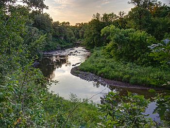
The Buffalo River in Buffalo River State Park
|
|
| Country | United States |
| Physical characteristics | |
| Main source | Tamarac Lake |
| River mouth | Red River of the North near Georgetown, Minnesota 853 feet (260 m) |
| Length | 139 miles (224 km) |
| Basin features | |
| Basin size | 1,189 square miles (3,080 km2) |
The Buffalo River is an important river in western Minnesota, United States. It flows for about 139 miles (224 kilometers). This river is a "tributary" of the Red River of the North. A tributary is a smaller river that flows into a larger one.
The Buffalo River is part of a huge "watershed." A watershed is an area of land where all the water drains into a common river or lake. This particular watershed eventually leads to Lake Winnipeg and the Nelson River, finally reaching Hudson Bay. The Buffalo River helps drain an area of about 1,189 square miles (3,080 square kilometers).

Contents
Where the River Flows
The Buffalo River starts from Tamarac Lake. This lake is located in the Tamarac National Wildlife Refuge in central Becker County. From there, the river generally flows towards the west.
Journey Through Towns
As it flows, the Buffalo River passes by several towns. These include Hawley and Georgetown. It also flows through Buffalo River State Park. This park is a great place to see the river and enjoy nature.
Joining the Red River
The Buffalo River finally flows into the Red River of the North. This meeting point is about one mile (1.6 kilometers) west of Georgetown.
South Branch Buffalo River
The biggest river that flows into the Buffalo River is called the South Branch Buffalo River. This branch is about 71.8 miles (115.6 kilometers) long.
South Branch's Path
The South Branch Buffalo River begins in western Otter Tail County. It first flows west into northern Wilkin County. Then, it turns and flows northward into Clay County. It joins the main Buffalo River near a town called Glyndon.
 | Claudette Colvin |
 | Myrlie Evers-Williams |
 | Alberta Odell Jones |

