Wilkin County, Minnesota facts for kids
Quick facts for kids
Wilkin County
|
|
|---|---|

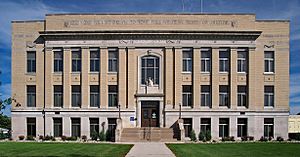
Wilkin County Courthouse in Breckenridge
|
|

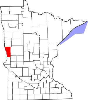
Location within the U.S. state of Minnesota
|
|
 Minnesota's location within the U.S. |
|
| Country | |
| State | |
| Founded | March 8, 1858 (created as Toombs) 1863 (renamed) March 6, 1868 (renamed) |
| Named for | Alexander Wilkin |
| Seat | Breckenridge |
| Largest city | Breckenridge |
| Area | |
| • Total | 751 sq mi (1,950 km2) |
| • Land | 751 sq mi (1,950 km2) |
| • Water | 0.69 sq mi (1.8 km2) 0.03%% |
| Population
(2020)
|
|
| • Total | 6,506 |
| • Estimate
(2023)
|
6,306 |
| • Density | 8.7/sq mi (3.4/km2) |
| Time zone | UTC−6 (Central) |
| • Summer (DST) | UTC−5 (CDT) |
| Congressional district | 7th |
Wilkin County is a place in Minnesota, a state in the United States. In 2020, about 6,506 people lived there. Its main town, called the county seat, is Breckenridge. The county is named after Alexander Wilkin. He was a lawyer and a soldier who served in the American Civil War.
Wilkin County is part of a larger area that includes Wahpeton, ND. This area is connected to the bigger Fargo-Wahpeton region.
Contents
History of Wilkin County's Name
In 1849, the new government of Minnesota Territory created nine large areas. One of these was called Pembina. Later, parts of Pembina became a new area on March 8, 1858. This new area was first named Toombs County. It was named after Robert Toombs, a politician from Georgia.
Why the Name Changed
Robert Toombs later joined a group that was against the United States government. Because of this, the people living in the county did not want it named after him anymore. So, in 1863, the county was renamed Andy Johnson County. This new name honored Andrew Johnson, who was a military governor at the time.
However, Andrew Johnson later became the US President. Some of his actions as president also made the county residents unhappy. So, on March 6, 1868, the county name was changed again. It became Wilkin County. This time, it was named after Colonel Alexander Wilkin. He was a lawyer in Minnesota and worked for the Minnesota Territory governor.
Breckenridge: The County Seat
The town of Breckenridge, Minnesota started to be settled in the 1850s. A town plan was made there in the spring of 1857. When Toombs County was created in 1858, Breckenridge was chosen as its main town, or county seat. It has stayed the county seat through all the name changes.
Geography of Wilkin County
Wilkin County is located on the western side of Minnesota. Its western border is right next to North Dakota. A river called the Bois de Sioux River flows north along this western border.
Rivers and Land
The Rabbit River flows west through the southern part of the county. It joins the Bois de Sioux River. The Otter Tail River flows through the middle of the county. It meets the Bois de Sioux River near Breckenridge. When these two rivers meet, they form the Red River. The Red River then flows north along the county's western edge, heading towards Hudson Bay in Canada.
Wilkin County's land has gentle, rolling hills. Most of the land is used for farming. The land slopes down towards the west and north. The highest point in the county is about 1,250 feet (381 meters) above sea level. The county covers a total area of about 751 square miles (1,945 square kilometers). Almost all of this is land, with only a tiny bit of water.
Main Roads in Wilkin County
 Interstate 94
 U.S. Highway 52
 U.S. Highway 75
 Minnesota State Highway 9
 Minnesota State Highway 55
 Minnesota State Highway 108
 Minnesota State Highway 210
Neighboring Counties
- Clay County - to the north
- Otter Tail County - to the east
- Grant County - to the southeast
- Traverse County - to the south
- Richland County, North Dakota - to the west
Nature Areas
- Akron State Wildlife Management Area
- Atherton State Wildlife Management Area
- Richard M. and Mathilde Rice Elliot Scientific and Natural Area
- Rothsay State Wildlife Management Area
- Sunnyside Township State Game Refuge
- Western Prairie Scientific and Natural Area
Lakes in Wilkin County
- Breckenridge Lake: This lake was formed by a dam on the Otter Tail River. It is located in Breckenridge Township.
Population Information
| Historical population | |||
|---|---|---|---|
| Census | Pop. | %± | |
| 1860 | 40 | — | |
| 1870 | 295 | 637.5% | |
| 1880 | 1,906 | 546.1% | |
| 1890 | 4,346 | 128.0% | |
| 1900 | 8,080 | 85.9% | |
| 1910 | 9,063 | 12.2% | |
| 1920 | 10,187 | 12.4% | |
| 1930 | 9,791 | −3.9% | |
| 1940 | 10,475 | 7.0% | |
| 1950 | 10,567 | 0.9% | |
| 1960 | 10,650 | 0.8% | |
| 1970 | 9,389 | −11.8% | |
| 1980 | 8,454 | −10.0% | |
| 1990 | 7,516 | −11.1% | |
| 2000 | 7,138 | −5.0% | |
| 2010 | 6,576 | −7.9% | |
| 2020 | 6,506 | −1.1% | |
| 2023 (est.) | 6,306 | −4.1% | |
| U.S. Decennial Census 1790-1960 1900-1990 1990-2000 2010-2020 |
|||
People in 2020
The 2020 Census showed how many people lived in Wilkin County and what their backgrounds were.
| Race | Number of People | Percentage |
|---|---|---|
| White | 5,918 | 91% |
| Black or African American | 41 | 0.63% |
| Native American | 87 | 1.34% |
| Asian | 8 | 0.12% |
| Pacific Islander | 1 | 0.02% |
| Other/Mixed | 240 | 3.7% |
| Hispanic or Latino | 211 | 3.24% |
Towns and Communities
Wilkin County has several towns and smaller communities.
Cities in Wilkin County
Smaller Communities (Unincorporated)
These are smaller places that are not officially cities.
Townships
Townships are smaller local government areas within the county.
- Akron
- Andrea
- Atherton
- Bradford
- Brandrup
- Breckenridge
- Campbell
- Champion
- Connelly
- Deerhorn
- Foxhome
- Manston
- McCauleyville
- Meadows
- Mitchell
- Nilsen
- Nordick
- Prairie View
- Roberts
- Sunnyside
- Tanberg
- Wolverton
See also
 In Spanish: Condado de Wilkin para niños
 | James Van Der Zee |
 | Alma Thomas |
 | Ellis Wilson |
 | Margaret Taylor-Burroughs |

