Foxhome, Minnesota facts for kids
Quick facts for kids
Foxhome, Minnesota
|
|
|---|---|

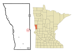
Location of Foxhome, Minnesota
|
|
| Country | United States |
| State | Minnesota |
| County | Wilkin |
| Incorporated | January 21, 1902 |
| Area | |
| • Total | 0.373 sq mi (0.965 km2) |
| • Land | 0.373 sq mi (0.965 km2) |
| • Water | 0.000 sq mi (0.000 km2) |
| Elevation | 1,027 ft (313 m) |
| Population
(2020)
|
|
| • Total | 126 |
| • Estimate
(2022)
|
123 |
| • Density | 337.80/sq mi (130.59/km2) |
| Time zone | UTC–6 (Central (CST)) |
| • Summer (DST) | UTC–5 (CDT) |
| ZIP Code |
56543
|
| Area code(s) | 218 |
| FIPS code | 27-22202 |
| GNIS feature ID | 2394803 |
| Sales tax | 6.875% |
Foxhome is a small city located in Wilkin County, Minnesota, in the United States. In 2020, about 126 people lived there. It is part of the larger Wahpeton Micropolitan Statistical Area, which includes nearby towns in North Dakota and Minnesota.
Contents
History of Foxhome
Foxhome got its name from a person named Robert A. Fox. He was a real estate agent who worked in the area. A post office was opened in Foxhome in 1896. The city officially became a town on January 21, 1902.
Geography of Foxhome
Foxhome is a very small city in terms of its size. It covers an area of about 0.373 square miles (0.965 square kilometers). All of this area is land; there are no large bodies of water within the city limits.
The city is located in Minnesota. You can find Foxhome between two other cities: Fergus Falls and Breckenridge. It is situated right along Minnesota State Highway 210, which is a main road in the area.
Population and People in Foxhome
The number of people living in Foxhome has changed over the years. This table shows how the population has grown and shrunk since 1910.
| Historical population | |||
|---|---|---|---|
| Census | Pop. | %± | |
| 1910 | 206 | — | |
| 1920 | 266 | 29.1% | |
| 1930 | 228 | −14.3% | |
| 1940 | 240 | 5.3% | |
| 1950 | 217 | −9.6% | |
| 1960 | 181 | −16.6% | |
| 1970 | 185 | 2.2% | |
| 1980 | 161 | −13.0% | |
| 1990 | 160 | −0.6% | |
| 2000 | 143 | −10.6% | |
| 2010 | 116 | −18.9% | |
| 2020 | 126 | 8.6% | |
| 2022 (est.) | 123 | 6.0% | |
| U.S. Decennial Census 2020 Census |
|||
What the 2010 Census Showed
In 2010, the census counted 116 people living in Foxhome. There were 52 households, which are like homes where people live. Out of these, 32 were families.
The city had about 313 people per square mile. There were 66 housing units in total. Most of the people living in Foxhome were White.
About 23% of the households had children under 18 living with them. The average household had 2.23 people. The average family had 2.84 people.
The average age of people in Foxhome was 47.3 years old. About 20.7% of the residents were under 18. Also, 16.4% of the people were 65 years old or older. Slightly more than half of the residents (55.2%) were male, and 44.8% were female.
See also
 In Spanish: Foxhome (Minnesota) para niños
 | Sharif Bey |
 | Hale Woodruff |
 | Richmond Barthé |
 | Purvis Young |

