Grant County, Minnesota facts for kids
Quick facts for kids
Grant County
|
||
|---|---|---|

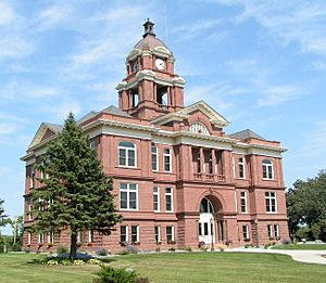
Grant County Courthouse
|
||
|
||

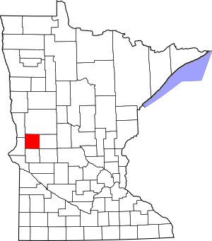
Location within the U.S. state of Minnesota
|
||
 Minnesota's location within the U.S. |
||
| Country | ||
| State | ||
| Founded | March 6, 1868 (created) 1874 (organized) |
|
| Named for | Ulysses S. Grant | |
| Seat | Elbow Lake | |
| Largest city | Elbow Lake | |
| Area | ||
| • Total | 575 sq mi (1,490 km2) | |
| • Land | 548 sq mi (1,420 km2) | |
| • Water | 27 sq mi (70 km2) 4.7%% | |
| Population
(2020)
|
||
| • Total | 6,074 | |
| • Estimate
(2023)
|
6,139 |
|
| • Density | 11.1/sq mi (4.3/km2) | |
| Time zone | UTC−6 (Central) | |
| • Summer (DST) | UTC−5 (CDT) | |
| Congressional district | 7th | |
Grant County is a county in Minnesota, a state in the United States. In 2020, about 6,074 people lived there. The main town, or county seat, is Elbow Lake.
Contents
History of Grant County
Grant County was officially started on March 6, 1868. It was named after Ulysses S. Grant. He was a famous general during the American Civil War and later became a U.S. President. The county's government officially began working in 1874.
Geography and Nature
Grant County is known for its rolling hills and many lakes. Most of the land is used for farming.
The Chippewa River flows through the eastern part of the county. The Mustinka River flows through the western and central parts. The highest point in the county is about 1,375 feet (419 meters) above sea level.
The county covers about 575 square miles (1,490 square kilometers). About 548 square miles (1,419 square kilometers) is land, and 27 square miles (70 square kilometers) is water.
Main Roads in Grant County
 Interstate 94
 U.S. Highway 52
 U.S. Highway 59
 Minnesota State Highway 9
 Minnesota State Highway 27
 Minnesota State Highway 55
 Minnesota State Highway 78
 Minnesota State Highway 79
Neighboring Counties
- Otter Tail County - north
- Douglas County - east
- Pope County - southeast
- Stevens County - south
- Traverse County - southwest
- Wilkin County - northwest
Protected Natural Areas
Grant County has several areas set aside to protect wildlife and nature. These are called State Wildlife Management Areas:
- Alvstad State Wildlife Management Area
- Berksow State Wildlife Management Area
- Chippewa State Wildlife Management Area
- Helsene State Wildlife Management Area
- Isaacson State Wildlife Management Area
- Kube-Swift State Wildlife Management Area
- Malsville State Wildlife Management Area
- Marple State Wildlife Management Area
- Mustinka State Wildlife Management Area
- Storm-Bordson State Wildlife Management Area
- Wilts State Wildlife Management Area
Population and People
The population of Grant County has changed over the years. Here's how it has grown and shrunk:
| Historical population | |||
|---|---|---|---|
| Census | Pop. | %± | |
| 1870 | 340 | — | |
| 1880 | 3,004 | 783.5% | |
| 1890 | 6,875 | 128.9% | |
| 1900 | 8,935 | 30.0% | |
| 1910 | 9,114 | 2.0% | |
| 1920 | 9,788 | 7.4% | |
| 1930 | 9,558 | −2.3% | |
| 1940 | 9,828 | 2.8% | |
| 1950 | 9,542 | −2.9% | |
| 1960 | 8,870 | −7.0% | |
| 1970 | 7,462 | −15.9% | |
| 1980 | 7,171 | −3.9% | |
| 1990 | 6,246 | −12.9% | |
| 2000 | 6,289 | 0.7% | |
| 2010 | 6,018 | −4.3% | |
| 2020 | 6,074 | 0.9% | |
| 2023 (est.) | 6,139 | 2.0% | |
| U.S. Decennial Census 1790-1960 1900-1990 1990-2000 2010-2020 |
|||
Population in 2020
In 2020, the census counted 6,074 people living in Grant County. Most people identified as White.
| Race | Num. | Perc. |
|---|---|---|
| White (NH) | 5,699 | 93.83% |
| Black or African American (NH) | 13 | 0.2% |
| Native American (NH) | 27 | 0.44% |
| Asian (NH) | 14 | 0.23% |
| Pacific Islander (NH) | 7 | 0.11% |
| Other/Mixed (NH) | 179 | 2.94% |
| Hispanic or Latino | 135 | 2.22% |
Towns and Communities
Grant County has several cities and smaller communities.
Cities
Smaller Communities
- Charlesville (partially in the county)
- Erdahl
Former Towns (Ghost Towns)
Some towns that used to exist in Grant County are now "ghost towns," meaning no one lives there anymore.
Townships
Townships are smaller local government areas within the county.
- Delaware Township
- Elbow Lake Township
- Elk Lake Township
- Erdahl Township
- Gorton Township
- Land Township
- Lawrence Township
- Lien Township
- Logan Township
- Macsville Township
- North Ottawa Township
- Pelican Lake Township
- Pomme de Terre Township
- Roseville Township
- Sanford Township
- Stony Brook Township
See also
 In Spanish: Condado de Grant (Minnesota) para niños
 | Anna J. Cooper |
 | Mary McLeod Bethune |
 | Lillie Mae Bradford |


