Ashby, Minnesota facts for kids
Quick facts for kids
Ashby
|
|
|---|---|

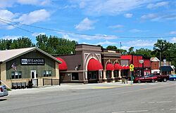
Buildings on the north side of Main Street
|
|
| Motto(s):
You'll Like Ashby
|
|

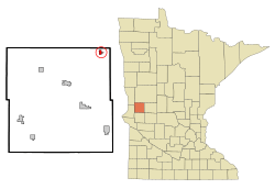
Location of Ashby, Minnesota
|
|
| Country | United States |
| State | Minnesota |
| County | Grant |
| Area | |
| • Total | 0.59 sq mi (1.53 km2) |
| • Land | 0.55 sq mi (1.43 km2) |
| • Water | 0.04 sq mi (0.10 km2) |
| Elevation | 1,286 ft (392 m) |
| Population
(2020)
|
|
| • Total | 469 |
| • Density | 851.18/sq mi (328.48/km2) |
| Time zone | UTC-6 (Central (CST)) |
| • Summer (DST) | UTC-5 (CDT) |
| ZIP code |
56309
|
| Area code(s) | 218 |
| FIPS code | 27-02422 |
| GNIS feature ID | 2393997 |
Ashby is a small city located in northeastern Grant County, Minnesota, United States. In 2020, about 469 people lived there.
Contents
History of Ashby
Ashby was first planned and mapped out in 1879. It was named after Gunder Ash, who was an early settler from Norway. A post office has been open in Ashby since 1880, helping people send and receive mail for a very long time.
On July 8, 2020, a very strong tornado hit areas just north of Ashby. This tornado was rated as an EF4, which means it was extremely powerful. It caused a lot of damage, destroying three farmhouses. Sadly, one person lost their life during this storm.
In 2021, a large accident happened during a snowstorm. About 80 cars were involved in a pileup on the road.
Geography and Location
Ashby covers a total area of about 0.59 square miles (1.53 square kilometers). Most of this area is land, about 0.55 square miles (1.43 square kilometers). A smaller part, about 0.04 square miles (0.10 square kilometers), is water.
Minnesota State Highway 78 is an important road that goes through Ashby. Interstate 94, a major highway, is also located nearby.
People of Ashby
| Historical population | |||
|---|---|---|---|
| Census | Pop. | %± | |
| 1890 | 231 | — | |
| 1900 | 279 | 20.8% | |
| 1910 | 334 | 19.7% | |
| 1920 | 388 | 16.2% | |
| 1930 | 358 | −7.7% | |
| 1940 | 384 | 7.3% | |
| 1950 | 443 | 15.4% | |
| 1960 | 426 | −3.8% | |
| 1970 | 415 | −2.6% | |
| 1980 | 486 | 17.1% | |
| 1990 | 469 | −3.5% | |
| 2000 | 472 | 0.6% | |
| 2010 | 446 | −5.5% | |
| 2020 | 469 | 5.2% | |
| U.S. Decennial Census 2020 Census |
|||
Population in 2010
According to the census from 2010, there were 446 people living in Ashby. These people lived in 197 households, and 132 of these were families.
Most of the people in Ashby were White (95.3%). A small number were African American (1.8%) or Asian (0.4%). About 1.1% of the population was Hispanic or Latino.
In the households, about 26.9% had children under 18 living with them. Many households (53.3%) were married couples living together. Some households had a female head (10.2%) or a male head (3.6%) without a spouse. About 31.5% of all households were people living alone. Also, 17.7% of households had someone aged 65 or older living by themselves.
The average age of people in Ashby was 43.2 years old. About 24.2% of residents were under 18. About 25.6% were 65 years old or older. The city had slightly more females (53.4%) than males (46.6%).
Community Life
Ashby has a public school that teaches students from kindergarten all the way through 12th grade. The school's sports teams are known as the "Ashby Arrows," and their team colors are maroon and gold.
Every year, a local group called "Coots Unlimited" holds a special event to raise money. This money is used to help rebuild and protect local wildlife areas. You can even see a metal statue of a coot (a bird that looks a bit like a duck) on the south side of the city.
Ashby is located near the edge of the Red River Valley. This area was shaped by ancient glaciers, which are like huge sheets of ice. Because of this, Ashby is surrounded by gently rolling hills and many great lakes for fishing. One of the most important lakes is Pelican Lake, which is just south of the city.
See also
 In Spanish: Ashby (Minnesota) para niños
 | Jessica Watkins |
 | Robert Henry Lawrence Jr. |
 | Mae Jemison |
 | Sian Proctor |
 | Guion Bluford |


