Douglas County, Minnesota facts for kids
Quick facts for kids
Douglas County
|
|
|---|---|

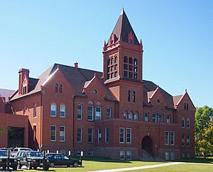
Douglas County Courthouse in Alexandria, Minnesota.
|
|

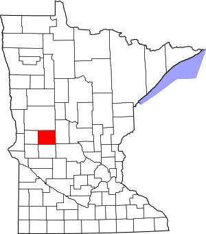
Location within the U.S. state of Minnesota
|
|
 Minnesota's location within the U.S. |
|
| Country | |
| State | |
| Founded | March 8, 1858 (created) 1866 (organized) |
| Named for | Stephen A. Douglas |
| Seat | Alexandria |
| Largest city | Alexandria |
| Area | |
| • Total | 720 sq mi (1,900 km2) |
| • Land | 637 sq mi (1,650 km2) |
| • Water | 83 sq mi (210 km2) 11%% |
| Population
(2020)
|
|
| • Total | 39,006 |
| • Estimate
(2023)
|
39,953 |
| • Density | 61.2/sq mi (23.6/km2) |
| Time zone | UTC−6 (Central) |
| • Summer (DST) | UTC−5 (CDT) |
| Congressional district | 7th |
Douglas County is a special area in the state of Minnesota, USA. It is like a local government region. In 2020, about 39,006 people lived here. The main town and government center is Alexandria.
Douglas County is also known for its special wine-grape growing area. This area is called the Alexandria Lakes AVA. It covers a huge space of about 10,880 acres (44 square kilometers).
Contents
The Story of Douglas County
Douglas County was officially started on March 8, 1858. This was just before Minnesota became a state. The county was named after a famous person named Stephen A. Douglas. He was a US Senator from Illinois at that time. The county's government was fully set up in 1866.
Exploring Douglas County's Land
Douglas County has rolling hills and many lakes and ponds. You will find lots of lakes in the middle part of the county, from north to south. The land usually slopes down towards the south and west. The highest point is in the northeast corner. It is about 1,483 feet (452 meters) above sea level.
The county covers about 720 square miles (1,865 square kilometers). Most of this area, 637 square miles (1,650 square kilometers), is land. The rest, 83 square miles (215 square kilometers), is water. About 11% of the county is water. Douglas County has more than 250 lakes!
This county has two main types of natural areas, called biomes. In the west and southeast, you will find prairie grasslands. In the middle, there are savannas, which are also like prairies. The northern, eastern, and south-central parts have forests with trees that lose their leaves. Douglas is one of 17 counties in Minnesota where savanna soils are common.
Main Roads in Douglas County
Airports in Douglas County
- Alexandria Municipal Airport ("Chandler Field") is a public airport. It is owned by the city.
Neighboring Counties
- Otter Tail County - to the north
- Todd County - to the east
- Stearns County - to the southeast
- Pope County - to the south
- Stevens County - to the southwest
- Grant County - to the west
Special Protected Areas
- Anderson State Wildlife Management Area
- Balgaard State Wildlife Management Area
- Chermak State Wildlife Management Area
- Herberger Lake State Wildlife Management Area
- Kensington State Wildlife Management Area
- La Grand State Wildlife Management Area
- Lake Carlos State Park
- Osakis State Wildlife Management Area North Unit (part)
- Red Rock Wildlife Management Area
- Roger M. Holmes State Wildlife Management Area
- Schnepf State Wildlife Management Area
- Thornberg State Wildlife Management Area
- Urness State Wildlife Management Area
People of Douglas County
| Historical population | |||
|---|---|---|---|
| Census | Pop. | %± | |
| 1870 | 4,239 | — | |
| 1880 | 9,130 | 115.4% | |
| 1890 | 14,606 | 60.0% | |
| 1900 | 17,964 | 23.0% | |
| 1910 | 17,669 | −1.6% | |
| 1920 | 19,039 | 7.8% | |
| 1930 | 18,813 | −1.2% | |
| 1940 | 20,369 | 8.3% | |
| 1950 | 21,304 | 4.6% | |
| 1960 | 21,313 | 0.0% | |
| 1970 | 22,892 | 7.4% | |
| 1980 | 27,839 | 21.6% | |
| 1990 | 28,839 | 3.6% | |
| 2000 | 32,821 | 13.8% | |
| 2010 | 36,009 | 9.7% | |
| 2020 | 39,006 | 8.3% | |
| 2023 (est.) | 39,953 | 11.0% | |
| U.S. Decennial Census 1790-1960 1900-1990 1990-2000 2010-2020 |
|||
What the 2020 Census Showed
The 2020 census counted the people living in Douglas County. Most people, about 94%, identified as White. Smaller groups included Black or African American, Native American, and Asian people. Some people also identified as being of more than one race. About 2.1% of the population was Hispanic or Latino.
| Race | Num. | Perc. |
|---|---|---|
| White (NH) | 36,629 | 94% |
| Black or African American (NH) | 223 | 0.6% |
| Native American (NH) | 104 | 0.3% |
| Asian (NH) | 227 | 0.6% |
| Pacific Islander (NH) | 11 | 0.03% |
| Other/Mixed (NH) | 997 | 2.6% |
| Hispanic or Latino | 815 | 2.1% |
Towns and Areas in Douglas County
Douglas County has several cities and smaller communities.
Cities
- Alexandria (This is the county seat, where the main government offices are)
- Brandon
- Carlos
- Evansville
- Forada
- Garfield
- Kensington
- Millerville
- Miltona
- Nelson
- Osakis (part of this city is in Douglas County)
Smaller Communities (Unincorporated)
These are places that are not officially cities or towns.
- Belle River
- Holmes City
- Leaf Valley
- Rose City
Townships
Townships are smaller local government areas.
- Alexandria Township
- Belle River Township
- Brandon Township
- Carlos Township
- Evansville Township
- Holmes City Township
- Hudson Township
- Ida Township
- La Grand Township
- Lake Mary Township
- Leaf Valley Township
- Lund Township
- Millerville Township
- Miltona Township
- Moe Township
- Orange Township
- Osakis Township
- Solem Township
- Spruce Hill Township
- Urness Township
See also
 In Spanish: Condado de Douglas (Minnesota) para niños
 | Dorothy Vaughan |
 | Charles Henry Turner |
 | Hildrus Poindexter |
 | Henry Cecil McBay |

