Todd County, Minnesota facts for kids
Quick facts for kids
Todd County
|
|
|---|---|

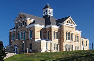
The Todd County Courthouse in Long Prairie
|
|

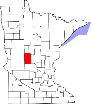
Location within the U.S. state of Minnesota
|
|
 Minnesota's location within the U.S. |
|
| Country | |
| State | |
| Founded | February 20, 1855 (created) January 1, 1867 (organized) |
| Named for | John Blair Smith Todd |
| Seat | Long Prairie |
| Largest city | Long Prairie |
| Area | |
| • Total | 980 sq mi (2,500 km2) |
| • Land | 945 sq mi (2,450 km2) |
| • Water | 35 sq mi (90 km2) 3.5%% |
| Population
(2020)
|
|
| • Total | 25,262 |
| • Estimate
(2023)
|
25,667 |
| • Density | 25.78/sq mi (9.95/km2) |
| Time zone | UTC−6 (Central) |
| • Summer (DST) | UTC−5 (CDT) |
| Congressional district | 7th |
Todd County is a county located in the middle of Minnesota, a state in the United States. In 2020, about 25,262 people lived here. The main town and government center, called the county seat, is Long Prairie.
Contents
History of Todd County
Todd County was officially created on February 20, 1855, by the Minnesota government at that time. However, the county's own government didn't start working until January 1, 1867. Long Prairie was chosen as the county seat from the beginning.
The county was named after John Blair Smith Todd. He was a special representative from the Dakota Territory in the U.S. Congress. He also served as a general in the Union Army during the American Civil War.
Geography and Nature
Todd County has rolling hills and many lakes. The land is mostly used for farming. Several rivers flow through or near the county. The Crow Wing River runs along the northeastern edge. The Long Prairie River flows through the middle and joins the Crow Wing River.
The highest point in the county is about 1,483 feet (452 meters) above sea level. This is found on the western border. The county covers a total area of about 980 square miles (2,538 square kilometers). Most of this is land, with about 35 square miles (91 square kilometers) being water.
Main Roads and Highways
Many important roads pass through Todd County, connecting it to other areas.
Neighboring Counties
Todd County shares its borders with several other counties.
- Wadena County (north)
- Cass County (northeast)
- Morrison County (east)
- Stearns County (south)
- Douglas County (west)
- Otter Tail County (northwest)
Lakes in Todd County
Todd County is home to many lakes, which are great for outdoor activities.
- Bass Lake
- Beauty Lake
- Big Birch Lake (part)
- Big Lake
- Big Swan Lake
- Buckhorn Lake
- Bunker Lake
- Cedar Lake
- Charlotte Lake
- Coal Lake
- Fairly Lake
- Fawn Lake
- Felix Lake
- Goose Lake
- Guernsey Lake
- Hayden Lake
- Horseshoe Lake
- Juergens Lake
- Keller Lake
- Lady Lake
- Lake Osakis (part)
- Latimer Lake
- Lawrence Lake
- Little Birch Lake (part)
- Little Sauk Lake
- Long Lake (Birchdale Twp.)
- Long Lake (Burnhamville Twp.)
- Maple Lake
- Mary Lake (part)
- McCarrahan Lake
- Mill Lake
- Mound Lake
- Mud Lake
- Pauley Lake
- Pendergast Lake
- Pine Island Lake
- Rice Lake
- Sauk Lake (part)
- Schreiers Lake
- Sheet Lake
- Trace Lake
- Twin Lakes (part)
- West Union Lake
Protected Natural Areas
There are several protected areas in Todd County. These places help keep nature safe and healthy.
- Aurzada Wildlife Management Area
- Buckhorn Lake State Wildlife Management Area
- Burleene State Wildlife Management Area
- Dower State Wildlife Management Area
- Elgin Woods Wildlife Management Area
- Iona Wildlife Management Area
- Ireland State Wildlife Management Area
- Long Prairie River Wildlife Management Area
- Oak Ridge State Wildlife Management Area
- Osakis Wildlife Management Area (part)
- Owen-Hinz Wildlife Management Area
- Quistorff Wildlife Management Area
- Randall State Wildlife Management Area
- Santer Wildlife Management Area
- Sheet Lake Wildlife Management Area
- West Union Wildlife Management Area
People and Population
The population of Todd County was 25,262 in 2020. The population has grown a little bit since then, with an estimated 25,667 people in 2023.
Who Lives in Todd County?
According to the 2020 Census, most people in Todd County are White (about 87.55%). There are also smaller groups of people from other backgrounds, including Hispanic or Latino (about 8.74%), Black or African American (0.37%), Asian (0.38%), Native American (0.3%), and Pacific Islander (0.29%). About 2.36% of the population identifies as other races or mixed races.
The Amish Community
Todd County has a notable population of Amish people. The Amish are a group who live a simple lifestyle, often without modern technology like cars or electricity. There are five different Amish communities in the county. In 2013, these communities had seven church districts, meaning there were about 1,000 Amish people living in Todd County.
| Location | Started in | Church districts in 2013 | Group |
|---|---|---|---|
| Bertha/Hewitt | 1973 | 1 | Swartzentruber |
| Long Prairie/Osakis | 1995 | 2 | |
| Clarissa/Browerville | 2001 | 2 | |
| Bertha/Staples | 2003 | 1 | Swartzentruber |
| Eagle Bend | 2007 | 1 |
Towns and Communities
Todd County has several cities and smaller communities where people live.
Cities in Todd County
- Bertha
- Browerville
- Burtrum
- Clarissa
- Eagle Bend
- Grey Eagle
- Hewitt
- Long Prairie (county seat)
- Osakis (partly in Douglas County)
- Staples (partly in Wadena County)
- West Union
Smaller Communities (Unincorporated)
These are smaller places that are not officially cities.
- Philbrook
- Pillsbury
- Ward Springs
Townships in Todd County
Townships are smaller local government areas within the county.
- Bartlett
- Bertha
- Birchdale
- Bruce
- Burleene
- Burnhamville
- Eagle Valley
- Fawn Lake
- Germania
- Gordon
- Grey Eagle
- Hartford
- Iona
- Kandota
- Leslie
- Little Elk
- Little Sauk
- Long Prairie
- Moran
- Reynolds
- Round Prairie
- Staples
- Stowe Prairie
- Turtle Creek
- Villard
- Ward
- West Union
- Wykeham
See also
 In Spanish: Condado de Todd (Minnesota) para niños
 | Valerie Thomas |
 | Frederick McKinley Jones |
 | George Edward Alcorn Jr. |
 | Thomas Mensah |

