Wadena County, Minnesota facts for kids
Quick facts for kids
Wadena County
|
|
|---|---|
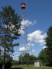
1928 Nimrod Fire Tower, Nimrod, Minnesota.
|
|
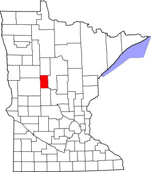
Location within the U.S. state of Minnesota
|
|
 Minnesota's location within the U.S. |
|
| Country | |
| State | |
| Founded | June 11, 1858 (created) February 21, 1873 (organized) |
| Named for | A trading post |
| Seat | Wadena |
| Largest city | Wadena |
| Area | |
| • Total | 543 sq mi (1,410 km2) |
| • Land | 536 sq mi (1,390 km2) |
| • Water | 7.0 sq mi (18 km2) 1.3%% |
| Population
(2020)
|
|
| • Total | 14,065 |
| • Estimate
(2023)
|
14,241 |
| • Density | 25.902/sq mi (10.001/km2) |
| Time zone | UTC−6 (Central) |
| • Summer (DST) | UTC−5 (CDT) |
| Congressional district | 8th |
Wadena County is a county in the U.S. state of Minnesota. In 2020, about 14,065 people lived there. The main city and county seat is Wadena.
Contents
History of Wadena County
The Minnesota Legislature officially created Wadena County on June 11, 1858. A small town started in 1871 where the city of Wadena is now. By 1873, it had a post office.
The state government made Wadena the county seat on February 21, 1873. The town was named after an old trading post about 15 kilometers (9 miles) to the east. That trading post was named for Chief Wadena, an Ojibwe Indian chief from the late 1800s.
Wadena County has 15 townships. Most of these townships are six miles square. They each contain 36 sections of land. Some townships, like Bullard and Thomastown, are shaped a bit differently. This is because their borders follow the Leaf and Crow Wing Rivers.
In the late 1800s and early 1900s, two main railroads crossed the county. The Northern Pacific line was built in 1872. It ran from east to west through Wadena. The Great Northern line was finished in 1891. It connected towns like Sebeka and Menahga. Most of these old rail lines are now gone. Some have been turned into walking and biking trails, like the Heartland Trail.
Wadena County has four historical societies. These groups help keep the county's history alive. They include the Wadena County Historical Society and groups in Verndale, Sebeka, and Menahga. In 2010, there were four school districts in the county. Long ago, in 1906, there were 52 school districts, mostly small rural schools. Sebeka once had one of Minnesota's largest creameries. A creamery is a place where dairy products like butter and cheese are made.
Geography and Nature
The Crow Wing River flows through the eastern part of Wadena County. The Partridge River flows east in the south. The Leaf River also flows east through the middle of the county. All these rivers eventually join the Crow Wing River.
The land in the county has gentle, rolling hills. These hills are shaped by the rivers. People use much of the land for farming. The highest point in the county is about 445 meters (1,460 feet) above sea level. This spot is near the northwest corner. Wadena County covers about 1,406 square kilometers (543 square miles). Most of this is land, with a small part being water.
Main Roads
Airports
- Staples Municipal Airport (SAZ)
Neighboring Counties
- Hubbard County - to the north
- Cass County - to the east
- Todd County - to the south
- Otter Tail County - to the southwest
- Becker County - to the northwest
Protected Natural Areas
- Burgen Lake Prairie Wildlife Management Area
- Dry Sand State Wildlife Management Area
- Huntersville State Forest
- Lyons State Forest
- Old Wadena County Park
Lakes of Wadena County
- Bill Lake
- Blueberry Lake
- Burgen Lake
- Duck Lake (part)
- Finn Lake
- Granning Lake
- Jim Cook Lake
- Lily Lake
- Lovejoy Lake
- Lower Twin Lake
- Mud Lake
- Radabaugh Lake
- Rice Lake
- Round Lake
- Simon Lake
- Spirit Lake
- Stocking Lake
- Strike Lake
- Thomas Lake
- Upper Twin Lake (part)
- Yaeger Lake
Population and People
| Historical population | |||
|---|---|---|---|
| Census | Pop. | %± | |
| 1870 | 6 | — | |
| 1880 | 2,080 | 34,566.7% | |
| 1890 | 4,058 | 95.1% | |
| 1900 | 7,921 | 95.2% | |
| 1910 | 8,652 | 9.2% | |
| 1920 | 10,699 | 23.7% | |
| 1930 | 10,990 | 2.7% | |
| 1940 | 12,772 | 16.2% | |
| 1950 | 12,806 | 0.3% | |
| 1960 | 12,199 | −4.7% | |
| 1970 | 12,412 | 1.7% | |
| 1980 | 14,192 | 14.3% | |
| 1990 | 13,154 | −7.3% | |
| 2000 | 13,713 | 4.2% | |
| 2010 | 13,843 | 0.9% | |
| 2020 | 14,065 | 1.6% | |
| 2023 (est.) | 14,241 | 2.9% | |
| U.S. Decennial Census 1790-1960 1900-1990 1990-2000 2010-2020 |
|||
The population of Wadena County has grown over the years. In 2020, there were 14,065 people living here. Most people in Wadena County are White. There are also smaller groups of Black, Native American, Asian, and Pacific Islander people. Some residents are of Hispanic or Latino background.
Cities and Towns
Cities
Unincorporated Communities
These are smaller places that are not officially cities.
Ghost Towns
These are towns that used to exist but are now abandoned.
- Leaf River
- Shell City
Townships
Townships are smaller local government areas within the county.
- Aldrich Township
- Blueberry Township
- Bullard Township
- Huntersville Township
- Leaf River Township
- Lyons Township
- Meadow Township
- North Germany Township
- Orton Township
- Red Eye Township
- Rockwood Township
- Shell River Township
- Thomastown Township
- Wadena Township
- Wing River Township
See also
 In Spanish: Condado de Wadena para niños
 | Isaac Myers |
 | D. Hamilton Jackson |
 | A. Philip Randolph |


