Cass County, Minnesota facts for kids
Quick facts for kids
Cass County
|
|
|---|---|

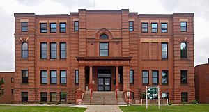
The Cass County Courthouse
|
|

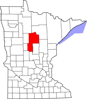
Location within the U.S. state of Minnesota
|
|
 Minnesota's location within the U.S. |
|
| Country | |
| State | |
| Founded | September 1, 1851 (created) 1897 (organized) |
| Named for | Lewis Cass |
| Seat | Walker |
| Largest city | Lake Shore |
| Area | |
| • Total | 2,414 sq mi (6,250 km2) |
| • Land | 2,022 sq mi (5,240 km2) |
| • Water | 393 sq mi (1,020 km2) 16%% |
| Population
(2020)
|
|
| • Total | 30,066 |
| • Estimate
(2023)
|
31,446 |
| • Density | 14.9/sq mi (5.8/km2) |
| Time zone | UTC−6 (Central) |
| • Summer (DST) | UTC−5 (CDT) |
| Congressional district | 8th |
Cass County is a county located in the middle of Minnesota, a state in the United States. In 2020, about 30,066 people lived here. The main town, or county seat, is Walker. Cass County was officially started in 1851 and began its government in 1897.
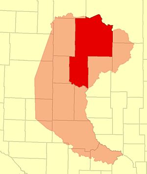
Cass County is part of the Brainerd area, which is a group of towns that are connected. A large part of the Leech Lake Indian Reservation is also located within the county.
Contents
History of Cass County
Cass County was created on September 1, 1851. The government of Minnesota Territory decided to form it. However, the county didn't set up its own government until 1897.
The county was named after Lewis Cass. He was an important political leader from Michigan in the 1800s.
Geography of Cass County
Cass County covers a total area of about 2,414 square miles. A big part of this, 393 square miles (16%), is water. This means there are many lakes and ponds here!
The land in Cass County has rolling hills covered with trees. It slopes down towards the south and east. The highest point in the county is about 1,614 feet above sea level.
The Crow Wing River flows along the southern edge of the county. The Gull River also flows through the lower part of the county. It eventually joins the Crow Wing River.
Main Roads in Cass County
Neighboring Counties
Cass County shares borders with several other counties:
- Itasca County - northeast
- Aitkin County - east
- Crow Wing County - southeast
- Morrison County - south
- Todd County - southwest
- Wadena County - west
- Hubbard County - northwest
- Beltrami County - north
Protected Natural Areas
Parts of these important natural areas are found in Cass County:
- Buena Vista State Forest
- Chippewa National Forest
- Crow Wing State Park
- Foot Hills State Forest
Climate and Weather in Cass County
| Weather chart for Walker, Minnesota | |||||||||||||||||||||||||||||||||||||||||||||||
|---|---|---|---|---|---|---|---|---|---|---|---|---|---|---|---|---|---|---|---|---|---|---|---|---|---|---|---|---|---|---|---|---|---|---|---|---|---|---|---|---|---|---|---|---|---|---|---|
| J | F | M | A | M | J | J | A | S | O | N | D | ||||||||||||||||||||||||||||||||||||
|
0.7
18
0
|
0.6
25
5
|
1.4
36
18
|
2.2
52
32
|
3.3
66
44
|
4.1
74
54
|
4.1
79
59
|
3.4
76
57
|
3.5
66
48
|
2.8
52
36
|
1.3
35
21
|
0.9
21
6
|
||||||||||||||||||||||||||||||||||||
| temperatures in °F precipitation totals in inches source: The Weather Channel |
|||||||||||||||||||||||||||||||||||||||||||||||
|
Metric conversion
|
|||||||||||||||||||||||||||||||||||||||||||||||
The weather in Cass County changes a lot throughout the year. In Walker, the county seat, January is usually the coldest month. Temperatures can average around 0°F. July is the warmest month, with average temperatures around 79°F.
However, temperatures can go to extremes! The coldest temperature ever recorded was -44°F in February 1996. The hottest was 103°F in August 1976.
The county also gets rain and snow. July usually has the most rain, with about 4.11 inches. February is often the driest month, with about 0.62 inches of precipitation.
Population and People
| Historical population | |||
|---|---|---|---|
| Census | Pop. | %± | |
| 1860 | 150 | — | |
| 1870 | 380 | 153.3% | |
| 1880 | 486 | 27.9% | |
| 1890 | 1,247 | 156.6% | |
| 1900 | 7,777 | 523.7% | |
| 1910 | 11,620 | 49.4% | |
| 1920 | 15,897 | 36.8% | |
| 1930 | 15,591 | −1.9% | |
| 1940 | 20,646 | 32.4% | |
| 1950 | 19,468 | −5.7% | |
| 1960 | 16,720 | −14.1% | |
| 1970 | 17,323 | 3.6% | |
| 1980 | 21,050 | 21.5% | |
| 1990 | 21,791 | 3.5% | |
| 2000 | 27,150 | 24.6% | |
| 2010 | 28,567 | 5.2% | |
| 2020 | 30,066 | 5.2% | |
| 2023 (est.) | 31,446 | 10.1% | |
| U.S. Decennial Census 1790-1960 1900-1990 1990-2000 2010-2020 |
|||
Every ten years, the United States counts its population in what's called a census. The numbers above show how the population of Cass County has changed over time. In 2020, the population was 30,066 people. By 2023, it was estimated to have grown to about 31,446 people.
Towns and Areas
Cass County has many different communities, from small cities to tiny villages.
Cities in Cass County
- Backus
- Bena
- Boy River
- Cass Lake
- Chickamaw Beach
- East Gull Lake
- Federal Dam
- Hackensack
- Lake Shore
- Longville
- Motley (partly in another county)
- Pillager
- Pine River
- Remer
- Walker (This is the county seat!)
Census-Designated Place
Unincorporated Communities
These are smaller places that are not officially cities or towns.
Townships
Townships are local government areas, often covering rural parts of the county.
- Ansel Township
- Barclay Township
- Becker Township
- Beulah Township
- Birch Lake Township
- Blind Lake Township
- Boy Lake Township
- Boy River Township
- Bull Moose Township
- Bungo Township
- Byron Township
- Crooked Lake Township
- Deerfield Township
- Fairview Township
- Gould Township
- Hiram Township
- Home Brook Township
- Inguadona Township
- Kego Township
- Leech Lake Township
- Lima Township
- Loon Lake Township
- Maple Township
- May Township
- McKinley Township
- Meadow Brook Township
- Moose Lake Township
- Otter Tail Peninsula Township
- Pike Bay Township
- Pine Lake Township
- Pine River Township
- Ponto Lake Township
- Poplar Township
- Powers Township
- Remer Township
- Rogers Township
- Salem Township
- Shingobee Township
- Slater Township
- Smoky Hollow Township
- Sylvan Township
- Thunder Lake Township
- Torrey Township
- Trelipe Township
- Turtle Lake Township
- Wabedo Township
- Walden Township
- Wilkinson Township
- Wilson Township
- Woodrow Township
Unorganized Territories
These are areas within the county that don't have their own township government.
See also
 In Spanish: Condado de Cass (Minnesota) para niños
 | Emma Amos |
 | Edward Mitchell Bannister |
 | Larry D. Alexander |
 | Ernie Barnes |


