Walker, Minnesota facts for kids
Quick facts for kids
Walker
|
|
|---|---|
|
City
|
|

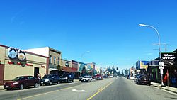
Photo: Erlend Bjørtvedt
|
|
| Nickname(s):
"The Big Place"
|
|

|
|
| Country | United States |
| State | Minnesota |
| County | Cass |
| Area | |
| • Total | 2.81 sq mi (7.28 km2) |
| • Land | 2.81 sq mi (7.28 km2) |
| • Water | 0.00 sq mi (0.00 km2) |
| Elevation | 1,352 ft (412 m) |
| Population
(2020)
|
|
| • Total | 966 |
| • Estimate
(2022)
|
987 |
| • Density | 343.89/sq mi (132.76/km2) |
| Time zone | UTC-6 (Central (CST)) |
| • Summer (DST) | UTC-5 (CDT) |
| ZIP code |
56484
|
| Area code(s) | 218 |
| FIPS code | 27-67792 |
| GNIS feature ID | 2397174 |
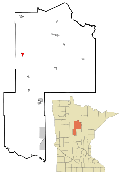
Walker is a city in Cass County, Minnesota, in the United States. About 966 people lived there in 2020. It is the main city and government center for Cass County.
Walker is also part of the larger Brainerd area. You can reach Walker using Minnesota State Highways 34, 200, and 371.
Contents
History of Walker, Minnesota
For thousands of years, different groups of indigenous peoples lived in the area where Walker is now. Before Europeans arrived, the Ojibwe people moved here from the Great Lakes. They became the main group, while the historic Dakota peoples, like the Assiniboine and Hidatsa, moved to other areas. Later, European American settlers came, following fur traders and trappers. They began to live on Native American lands.
Founding and Early Growth
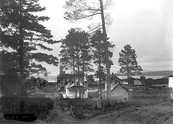
The city of Walker was started in 1896 by Patrick McGarry. This happened after a railroad was built to the area. McGarry named the town after a big logging business owner, Thomas B. Walker. He hoped Thomas B. Walker would build a sawmill there.
However, Thomas B. Walker decided to build his sawmill in nearby Akeley instead. His wife did not like the many bars in Walker, which was a busy frontier town. Even without Thomas B. Walker's sawmill, the city of Walker grew. Four other logging companies helped create jobs and businesses.
Tourism and the Ah-Gwah-Ching Center
Later, tourism became an important industry. In the 1900s, people from cities started visiting rural areas like Walker. They came to enjoy the lakes, fishing, hunting, and water sports. The city's population was largest in 1950.
In 1907, the Ah-Gwah-Ching Center opened in Walker. It was built to help people with tuberculosis (TB), a serious lung disease. At that time, the best treatment was good food and rest. By 1927, the center had 300 patients.
The Ah-Gwah-Ching Center was very large. It had its own farm and dairy cows. Patients and staff even put on plays and made a newspaper. It once had its own train station. During the Great Depression, artists created art there as part of a government program. Today, it has the largest collection of this art in Minnesota. In 1962, the center became a nursing home for people with mental health needs. The buildings are now listed as important historic places.
Geography and Climate
Walker is located on the southwest side of Leech Lake. This is the third largest lake in Minnesota. The city covers about 2.47 square miles (7.28 square kilometers) of land. There is no water area within the city limits.
Nearby Towns and Lakes
Other cities and towns close to Walker include Hackensack, Akeley, Whipholt, Laporte, and Bemidji. Onigum is also nearby and is part of the Leech Lake Indian Reservation.
Local Weather Patterns
Walker has a climate with warm summers and cold winters. Here is a quick look at the average temperatures and rainfall:
| Climate data for Walker, Minnesota | |||||||||||||
|---|---|---|---|---|---|---|---|---|---|---|---|---|---|
| Month | Jan | Feb | Mar | Apr | May | Jun | Jul | Aug | Sep | Oct | Nov | Dec | Year |
| Mean daily maximum °F (°C) | 17 (−8) |
24 (−4) |
33 (1) |
51 (11) |
64 (18) |
73 (23) |
78 (26) |
75 (24) |
66 (19) |
53 (12) |
35 (2) |
23 (−5) |
49 (10) |
| Mean daily minimum °F (°C) | −2 (−19) |
3 (−16) |
15 (−9) |
30 (−1) |
41 (5) |
51 (11) |
57 (14) |
55 (13) |
44 (7) |
35 (2) |
21 (−6) |
5 (−15) |
30 (−1) |
| Average precipitation inches (mm) | 0.7 (18) |
0.6 (15) |
1.2 (30) |
2.0 (51) |
2.9 (74) |
4.0 (100) |
3.7 (94) |
3.4 (86) |
2.7 (69) |
2.0 (51) |
1.2 (30) |
0.8 (20) |
25.3 (640) |
| Source: weatherbase.com | |||||||||||||
Population and People
| Historical population | |||
|---|---|---|---|
| Census | Pop. | %± | |
| 1900 | 500 | — | |
| 1910 | 917 | 83.4% | |
| 1920 | 785 | −14.4% | |
| 1930 | 618 | −21.3% | |
| 1940 | 939 | 51.9% | |
| 1950 | 1,192 | 26.9% | |
| 1960 | 1,180 | −1.0% | |
| 1970 | 1,073 | −9.1% | |
| 1980 | 970 | −9.6% | |
| 1990 | 950 | −2.1% | |
| 2000 | 1,069 | 12.5% | |
| 2010 | 941 | −12.0% | |
| 2020 | 966 | 2.7% | |
| 2022 (est.) | 987 | 4.9% | |
| U.S. Decennial Census 2020 Census |
|||
How Many People Live Here?
In 2010, there were 941 people living in Walker. These people lived in 452 households, and 205 of these were families. The city had about 381 people per square mile. There were 605 homes in total.
Most of the people in Walker were White (88.0%). About 7.2% were Native American. A small number were Asian (1.1%) or from other backgrounds. About 1.3% of the population was Hispanic or Latino.
Households and Age Groups
About 21.2% of households had children under 18 living there. Many households (54.6%) were not families. This means they might be single people or roommates. Almost half of all households (48.0%) had just one person living alone. About 23.4% of households had someone 65 years or older living by themselves.
The average age of people in Walker was 49 years old. About 19.2% of residents were under 18. About 30.1% were 65 years or older. The city had more females (55.5%) than males (44.5%).
Education in Walker
Walker Public Schools are part of the Walker-Hackensack-Akeley School District. This district includes Walker-Hackensack-Akeley Elementary School and Walker-Hackensack-Akeley High School (WHA). Kevin Wellen is the Superintendent. The Walker and Akeley school districts joined together in 1990. Walker is also home to Immanuel Lutheran School.
Transportation Options
Walker has its own airport, called Walker Airport (Y49). It is located four miles northwest of the city. The airport has one runway that is 3,220 feet long and 75 feet wide. It has an asphalt surface.
In the year ending July 31, 2017, the airport had 9,200 aircraft operations. This means about 25 planes took off or landed each day. Most of these were general aviation flights, which are private or business flights, not commercial airlines. The airport was home to 16 single-engine planes, 2 multi-engine planes, and 1 helicopter.
Media and News
Television Channels
Walker is part of the Minneapolis / Saint Paul television market. This means people in Walker watch TV channels from that area.
| Channel | Callsign | Affiliation | Branding | Subchannels | Owner | |
|---|---|---|---|---|---|---|
| (Virtual) | Channel | Programming | ||||
| 12.1 | KCCW (WCCO Satellite) |
CBS | WCCO 4 | 12.2 | Start TV | CBS Corporation |
| 21.1 | K21HX-D | FOX | Fox 9 | 21.2 21.3 21.4 |
FOX 9+ Movies! Local |
Leech Lake Television Corporation |
| 24.1 | K21HX-D | NBC | KARE 11 | 24.2 24.3 24.4 |
PBS (KAWE) Weather ABC (KSAX) |
Leech Lake Television Corporation |
| 35.1 | K35KH-D | CW | CW 23 | 35.2 35.3 35.4 |
Court TV MeTV 45TV |
Leech Lake Television Corporation |
Local Newspapers
The main local newspaper is The Pilot Independent / Co-Pilot Shopper.
Radio Stations in Walker
You can listen to many radio stations in Walker:
- FM radio
- 88.5 Minnesota Public Radio (MPR)
- 90.1 KOJB The Eagle, Native American music and programs
- 92.5 KXKK
- 94.5 KDLB
- 97.5 KDKK
- 99.1 KLLZ-FM Z99 Classic Rock
- 101.9 KQKK
- 102.5 KKWB-FM
- 104.3 KLKS
- AM radio
- 820 WBKK-AM
- 870 KPRM
- 1070 KSKK
- 1570 KAKK
Notable People from Walker
Some well-known people have connections to Walker:
- Jimmy Darts, a social media personality
- Mary Welsh Hemingway, a journalist and the wife of writer Ernest Hemingway
- Donald D. Lundrigan, a Minnesota state representative and lawyer
- Noah W. Sawyer, another Minnesota state representative
- Ber, an Indie pop musician
See also
 In Spanish: Walker (Minnesota) para niños
 | Madam C. J. Walker |
 | Janet Emerson Bashen |
 | Annie Turnbo Malone |
 | Maggie L. Walker |


