Leech Lake Indian Reservation facts for kids
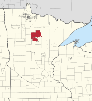
The Leech Lake Reservation (called Gaa-zagaskwaajimekaag in the Ojibwe language) is a special area of land for the Leech Lake Band of Ojibwe people. It's located in north-central Minnesota, across parts of Cass, Itasca, Beltrami, and Hubbard counties. The Leech Lake Band of Ojibwe is one of six groups that make up the Minnesota Chippewa Tribe. According to the 2020 census, about 11,388 people live on the reservation, making it the second most populated reservation in Minnesota.
Contents
History of Leech Lake Reservation
The Leech Lake Reservation wasn't created all at once. Instead, it grew over many years through different agreements, government orders, and laws. The main parts of the reservation were first set up by a treaty in 1855. This treaty created three smaller reservations for the Pillager Band of Chippewa Indians at Leech Lake, Cass Lake, and Lake Winnibigoshish.
Later, new treaties in 1864 and 1867 changed these areas. The United States government tried to gather Ojibwe people from other reservations into one place, but this didn't work very well. More changes happened in the 1870s through special orders from the government. One of these orders created the White Oak Point reservation for the Mississippi Band.
In the late 1800s, laws like the Dawes Act of 1887 and the Nelson Act of 1889 allowed the United States to divide tribal land into private plots. Some of these plots were kept by tribal members. However, much of the reservation land was sold to logging companies and settlers who were not Native American. Also, the Chippewa National Forest was created in the early 1900s on tribal land that hadn't been divided. Because of these changes, by 1934, less than 5% of the reservation was still owned by the Ojibwe people.
After the Indian Reorganization Act of 1934, the current "Greater" Leech Lake Indian Reservation was formed. It combined the Leech Lake, Cass Lake, and Lake Winnibigoshish reservations of the Pillager Band, along with the Chippewa Indian Reservation of the Lake Superior Band, and the White Oak Point reservation of the Mississippi Band.
Between 1948 and 1959, the U.S. government continued to transfer thousands of acres of tribal land at Leech Lake to the U.S. Department of Agriculture. This land was added to the Chippewa National Forest. However, in 1959, the government stopped these transfers. They realized they had acted illegally by selling the land without the permission of the tribal landowners. In 2020, a new law was passed by Congress. This law allowed about 11,760 acres of this illegally taken land to be returned from the Chippewa National Forest to the Leech Lake Reservation. This returned land officially became part of the reservation again in 2024.
Even with this land returned, the Leech Lake Band still owns a smaller part of its reservation than any other Ojibwe group in Minnesota. About 40% of the Chippewa National Forest is still located on reservation land.
Geography of the Reservation
The Leech Lake Reservation covers a total area of about 1,310 square miles (3,393 square kilometers). About 973 square miles (2,520 square kilometers) of this is land, and 337 square miles (873 square kilometers) is water.
About one-fourth of the reservation is covered by lakes. The biggest lakes on the reservation are Leech Lake, Lake Winnibigoshish, and Cass Lake. The Leech Lake Band uses 40 lakes to grow wild rice. The community produces more wild rice than any other reservation in Minnesota. The Leech Lake Reservation is the second largest in Minnesota by land area, after the White Earth Indian Reservation. It is the largest in terms of its total area, including both land and water.
Communities on the Reservation
The Leech Lake Reservation has eleven main villages. Two other communities also have many Leech Lake Band members living there. Most of the Leech Lake communities are found within or near the forests of the Chippewa National Forest.
The largest community is Cass Lake, which is located on the southwest side of Cass Lake. Other large settlements include Ball Club, Onigum, Inger, and Bena. In some communities, houses are built along just one road, with homes on both sides.
- Ah-gwah-ching (part)
- Baker
- Ball Club
- Bena
- Benedict (part)
- Brevik
- Cass Lake
- Deer River (part)
- Dunbar
- Inger
- Longville (part)
- Max
- Mission
- Oak Point
- Onigum
- Oslund
- Pennington
- Ryan Village
- Smokey Point
- Squaw Lake
- Sugar Point
- Whipholt
- Wilkinson
Population Information
As of the 2020 census, the Leech Lake Reservation had a population of 11,388 people. There were about 11.7 people per square mile (4.5 people per square kilometer).
The Leech Lake Reservation has a mix of people, including many who are not Native American. This is partly because of the historical sales of reservation lands in the late 1800s. In 2020, the population was made up of about 49.3% White people and 43.8% Native American people. A small number of people were Black, Asian, or from other backgrounds. About 6.3% of the population identified as being from two or more races. About 1.7% of the population was Hispanic or Latino.
Education on the Reservation
There are two schools on the reservation that are run by the tribe. These are the Bug-O-Nay-Ge-Shig School and the Leech Lake Tribal College.
 | Calvin Brent |
 | Walter T. Bailey |
 | Martha Cassell Thompson |
 | Alberta Jeannette Cassell |


