Beltrami County, Minnesota facts for kids
Quick facts for kids
Beltrami County
|
|
|---|---|

|
|

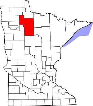
Location within the U.S. state of Minnesota
|
|
 Minnesota's location within the U.S. |
|
| Country | |
| State | |
| Founded | February 28, 1866 (created) 1896 (organized) |
| Named for | Giacomo Constantino Beltrami |
| Seat | Bemidji |
| Largest city | Bemidji |
| Area | |
| • Total | 3,056 sq mi (7,920 km2) |
| • Land | 2,505 sq mi (6,490 km2) |
| • Water | 551 sq mi (1,430 km2) 18%% |
| Population
(2020)
|
|
| • Total | 46,228 |
| • Estimate
(2023)
|
46,718 |
| • Density | 18.6/sq mi (7.2/km2) |
| Time zone | UTC−6 (Central) |
| • Summer (DST) | UTC−5 (CDT) |
| Congressional districts | 7th, 8th |
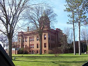
Beltrami County (/bɛlˈtræmi/ bel-TRAM-ee) is a county in northern Minnesota. In 2020, about 46,228 people lived there. The main city and government center is Bemidji.
The county is named after Giacomo Beltrami. He was an Italian explorer who visited the area in 1825. Beltrami County was officially created in 1866.
Bemidji is part of a "Micropolitan Statistical Area." This means it's a smaller city area with strong ties to nearby towns.
Parts of two Indian reservations are in the county. These are the Leech Lake and Red Lake reservations. The very start of the Mississippi River flows through the southern part of the county, right through Bemidji. Beltrami is one of only three counties in Minnesota that touches nine other counties!
Contents
Exploring Beltrami County's Land
Beltrami County is known for its beautiful natural areas. The southwest part of the county is considered the start of the Mississippi River. This famous river flows through the southern part of the county.
A big part of the middle and upper county is covered by the two sections of Red Lake. The land here has rolling hills covered with trees. You'll also find many lakes and ponds.
The county covers about 3,056 square miles. About 551 square miles of this is water. This makes it the fourth-largest county in Minnesota by total area.
Main Roads to Travel
You can get around Beltrami County using several important highways:
Neighboring Counties
Beltrami County shares borders with nine other counties:
- Lake of the Woods County - north
- Koochiching County - northeast
- Itasca County - east
- Cass County - southeast
- Hubbard County - south
- Clearwater County - southwest
- Pennington County - west
- Marshall County - west
- Roseau County - northwest
Parks and Forests to Explore
Beltrami County has many protected areas for nature lovers:
- Buena Vista State Forest
- Chippewa National Forest (part)
- Lake Bemidji State Park
- Mississippi Headwaters State Forest (part)
- Pine Island State Forest (part)
- Red Lake Peatland Scientific and Natural Area (part)
- Three Island Lake County Park
Weather in Beltrami County
| Weather chart for Bemidji, Minnesota | |||||||||||||||||||||||||||||||||||||||||||||||
|---|---|---|---|---|---|---|---|---|---|---|---|---|---|---|---|---|---|---|---|---|---|---|---|---|---|---|---|---|---|---|---|---|---|---|---|---|---|---|---|---|---|---|---|---|---|---|---|
| J | F | M | A | M | J | J | A | S | O | N | D | ||||||||||||||||||||||||||||||||||||
|
0.7
16
-4
|
0.6
24
3
|
0.9
36
16
|
1.5
53
30
|
2.7
67
43
|
4.1
75
52
|
4.3
79
57
|
3.5
77
55
|
2.8
66
45
|
2.3
54
35
|
1.1
34
19
|
0.6
21
3
|
||||||||||||||||||||||||||||||||||||
| temperatures in °F precipitation totals in inches source: The Weather Channel |
|||||||||||||||||||||||||||||||||||||||||||||||
|
Metric conversion
|
|||||||||||||||||||||||||||||||||||||||||||||||
The weather in Beltrami County can change a lot. In Bemidji, the average temperature in January is about -4°F. In July, it's around 79°F.
The coldest temperature ever recorded was -50°F in January 1950. The hottest was 101°F in July 1975. The county gets the most rain in July.
Who Lives in Beltrami County?
| Historical population | |||
|---|---|---|---|
| Census | Pop. | %± | |
| 1870 | 80 | — | |
| 1880 | 10 | −87.5% | |
| 1890 | 312 | 3,020.0% | |
| 1900 | 11,030 | 3,435.3% | |
| 1910 | 19,337 | 75.3% | |
| 1920 | 27,079 | 40.0% | |
| 1930 | 20,707 | −23.5% | |
| 1940 | 26,107 | 26.1% | |
| 1950 | 24,962 | −4.4% | |
| 1960 | 23,425 | −6.2% | |
| 1970 | 26,373 | 12.6% | |
| 1980 | 30,982 | 17.5% | |
| 1990 | 34,384 | 11.0% | |
| 2000 | 39,650 | 15.3% | |
| 2010 | 44,442 | 12.1% | |
| 2020 | 46,228 | 4.0% | |
| 2023 (est.) | 46,718 | 5.1% | |
| U.S. Decennial Census 1790-1960 1900-1990 1990-2000 2010-2020 |
|||
The population of Beltrami County has grown over the years. In 2020, the county had 46,228 people.
People in 2020
| Race | Num. | Perc. |
|---|---|---|
| White | 32,445 | 70.2% |
| Black or African American | 519 | 1.12% |
| Native American | 9,198 | 20% |
| Asian | 268 | 0.6% |
| Pacific Islander | 15 | 0.03% |
| Other/Mixed | 2,675 | 5.8% |
| Hispanic or Latino | 1,108 | 2.4% |
Cities and Towns
Beltrami County has several cities and many smaller communities.
Cities in the County
Other Communities
There are also many townships and smaller places where people live. Some of these are:
Learning in Beltrami County
Students in Beltrami County attend schools in various districts:
- Bemidji Public School District
- Blackduck Public School District
- Cass Lake-Bena Public Schools
- Kelliher Public School District
- Red Lake Public School District
- Grygla Public School District
See also
 In Spanish: Condado de Beltrami para niños
 | Misty Copeland |
 | Raven Wilkinson |
 | Debra Austin |
 | Aesha Ash |

