
Koochiching County, Minnesota facts for kids
Quick facts for kids
Koochiching County
|
|
|---|---|

Koochiching County Courthouse
|
|

Location within the U.S. state of Minnesota
|
|
 Minnesota's location within the U.S. |
|
| Country | |
| State | |
| Founded | December 19, 1906 |
| Named for | Ojibway words for neighbor lake, river |
| Seat | International Falls |
| Largest city | International Falls |
| Area | |
| • Total | 3,154 sq mi (8,170 km2) |
| • Land | 3,104 sq mi (8,040 km2) |
| • Water | 50 sq mi (100 km2) 1.6%% |
| Population
(2020)
|
|
| • Total | 12,062 |
| • Estimate
(2023)
|
11,751 |
| • Density | 3.9/sq mi (1.5/km2) |
| Time zone | UTC−6 (Central) |
| • Summer (DST) | UTC−5 (CDT) |
| Congressional district | 8th |
Koochiching County (pronounced KOO-chitch-ing) is a county in the state of Minnesota, USA. In 2020, about 12,062 people lived there. The main city and county seat is International Falls. Part of the Bois Forte Indian Reservation is located in the county. A small part of Voyageurs National Park also reaches into its borders.
Contents
History of Koochiching County
Ancient Times and Lake Agassiz
About 10,000 years ago, a huge ancient lake called Lake Agassiz covered almost 90% of Koochiching County. When this giant lake dried up, it left behind low, wet areas filled with decayed plants. These areas are known as muskeg. Because of this, three-quarters of northern Koochiching County has a thick layer of peat, which is like a spongy soil made of old plants. This peat can be anywhere from 2 to 50 feet deep!
What Does "Koochiching" Mean?
The name "Koochiching" comes from the Ojibwe word Gojijiing or the Cree word Kocicīhk. Both of these words mean "at the place of inlets." This likely refers to the nearby Rainy Lake and Rainy River.
Early French explorers named these waters Lac à la Pluie (Rainy Lake) and Rivière à la Pluie (Rainy River). They chose these names because of the misty, rain-like spray that came from the waterfalls on the Rainy River. Later, the settlement that grew there became known as International Falls.
Early Settlers and the County's Founding
Koochiching County was one of the last areas in Minnesota to be settled by European newcomers. People started arriving in the late 1800s. Some of the last lands were given up by the Chippewa people in a 1904 Land Act.
Many settlers claimed land between 1900 and 1910. These early residents were often lumberjacks, farmers, and people from other trades. They faced many challenges like being far from other towns, getting sick, dealing with harsh weather, and not having much money. But they worked hard to build schools and churches, and they pushed for better roads.
Koochiching County is one of the newest counties in Minnesota. It was officially created in 1906. Before that, it was part of Itasca County.
Geography and Nature

Koochiching County is located at the very northern edge of Minnesota. Its northern border touches the southern border of Canada, with the Rainy River flowing between them. Several rivers in the county flow north into the Rainy River, including the Rat Root River, Little Fork River, Big Fork River, and Black River.
The county's land has gentle, rolling hills. You'll also find many swampy areas, especially where the ancient Lake Agassiz was deepest. These low areas have thick layers of peat. The land is mostly flat, but there are some rocky areas made of very old precambrian rock. Some of the bedrock here, like Ely greenstone, is thought to be among the oldest on Earth!
The land generally slopes downwards towards the north. The highest point in the county is about 1,515 feet (462 meters) above sea level, located on the western part of its southern border.
Koochiching County covers a total area of about 3,154 square miles (8,169 square kilometers). Most of this is land (3,104 square miles or 8,039 square kilometers), and about 50 square miles (130 square kilometers) is water. It's the second-largest county in Minnesota by land area and the third-largest by total area.
Main Roads in the County
 U.S. Highway 53
 U.S. Highway 71
 Minnesota State Highway 1
 Minnesota State Highway 6
 Minnesota State Highway 11
 Minnesota State Highway 46
 Minnesota State Highway 65
 Minnesota State Highway 217
Neighboring Areas
Koochiching County shares its borders with several other counties and a district in Canada:
- Rainy River District, Ontario - to the north (in Canada)
- Saint Louis County - to the east
- Itasca County - to the south
- Beltrami County - to the southwest
- Lake of the Woods County - to the northwest
Special Protected Areas
The county is home to several important natural areas:
- East Rat Root River Scientific and Natural Area
- Lost River Peatland Scientific and Natural Area
- Myrtle Lake Peatland Scientific and Natural Area
- Pine Island State Forest
- Smoky Bear State Forest
- South Black River Peatland Scientific and Natural Area
- Part of Superior National Forest
- Part of Voyageurs National Park
Lakes in Koochiching County
Many lakes dot the landscape of Koochiching County:
- Bartlett Lake
- Battle Lake
- Cameron Lake
- Clear Lake
- Dark Lake
- Franklin Lake
- Larson Lake
- Little Constance Lake
- Little Lake
- Lost Lake
- Moose Lake
- Myrtle Lake
- Part of Nett Lake
- Pine Lake
- Pocquette Lake
- Part of Rainy Lake
- Rat Root Lake
- Seretha Lake
- Silversack Lake
- Teufer Lake
Population and People
| Historical population | |||
|---|---|---|---|
| Census | Pop. | %± | |
| 1910 | 6,431 | — | |
| 1920 | 13,520 | 110.2% | |
| 1930 | 14,078 | 4.1% | |
| 1940 | 16,930 | 20.3% | |
| 1950 | 16,910 | −0.1% | |
| 1960 | 18,190 | 7.6% | |
| 1970 | 17,131 | −5.8% | |
| 1980 | 17,571 | 2.6% | |
| 1990 | 16,299 | −7.2% | |
| 2000 | 14,355 | −11.9% | |
| 2010 | 13,311 | −7.3% | |
| 2020 | 12,062 | −9.4% | |
| 2023 (est.) | 11,751 | −11.7% | |
| U.S. Decennial Census 1790–1960 1900–1990 1990–2000 2010–2020 |
|||
The population of Koochiching County has changed over the years. In 1910, there were about 6,431 people. The population grew steadily until the 1960s, reaching its highest point around 18,190 people. Since then, the number of residents has slowly decreased. In 2020, the population was 12,062.
Who Lives in Koochiching County?
Based on the 2020 Census, here's a look at the different groups of people living in Koochiching County:
| Race | Number of People | Percentage of Total |
|---|---|---|
| White | 10,920 | 90.53% |
| Black or African American | 44 | 0.36% |
| Native American | 278 | 2.3% |
| Asian | 34 | 0.3% |
| Pacific Islander | 12 | 0.1% |
| Other/Mixed | 607 | 5.03% |
| Hispanic or Latino | 167 | 1.4% |
Communities in Koochiching County
Koochiching County is unique because it's one of only two counties in Minnesota that doesn't have organized township governments. This means the county itself handles many services that townships usually provide. Instead, the county has several cities and large "unorganized territories."
Cities You Can Find Here
- Big Falls
- International Falls (This is the county seat, where the main government offices are. It was called Koochiching until 1903.)
- Littlefork
- Mizpah
- Northome
- Ranier
Unorganized Territories
These are large areas of the county that are not part of any city or organized township.
- East Koochiching
- Nett Lake
- Northome
- Northwest Koochiching
- Rainy Lake
- South Koochiching
Other Small Communities
You'll also find many smaller, unincorporated communities throughout the county:
- Birchdale
- Bramble
- Central
- Craigville
- Ericsburg
- Forest Grove
- Frontier
- Gates Corner
- Gemmell
- Grand Falls
- Indus
- Island View
- Jameson
- Laurel
- Lindford
- Loman
- Manitou
- Margie
- Nakoda
- Pelland
- Pinetop
- Rauch
- Ray
- Silverdale
- Wildwood
Places That Are No Longer There (Ghost Towns)
Some communities that once existed in Koochiching County are now considered "ghost towns":
- Border
- Fairland
- Falls Junction
- Rainy Lake City
- Ridge
- The Pines
- Wayland
Images for kids
-
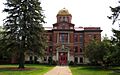
Koochiching County Courthouse
-
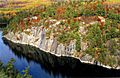
Voyageurs National Park is partly in Koochiching County.
See also
 In Spanish: Condado de Koochiching para niños
