Lake of the Woods County, Minnesota facts for kids
Quick facts for kids
Lake of the Woods County
|
|
|---|---|

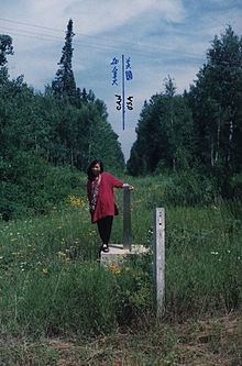
US–Canada border monument no. 919
|
|

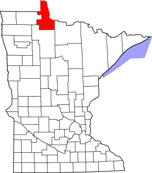
Location within the U.S. state of Minnesota
|
|
 Minnesota's location within the U.S. |
|
| Country | |
| State | |
| Founded | November 28, 1922 (created by vote) January 1, 1923 (organized) |
| Named for | Lake of the Woods (lake) |
| Seat | Baudette |
| Largest city | Baudette |
| Area | |
| • Total | 1,775 sq mi (4,600 km2) |
| • Land | 1,298 sq mi (3,360 km2) |
| • Water | 477 sq mi (1,240 km2) 27%% |
| Population
(2020)
|
|
| • Total | 3,763 |
| • Estimate
(2023)
|
3,778 |
| • Density | 2.9/sq mi (1.1/km2) |
| Time zone | UTC−6 (Central) |
| • Summer (DST) | UTC−5 (CDT) |
| Congressional district | 8th |
| Website | co.lake-of-the-woods.mn.us |
Lake of the Woods County is the county farthest north in the state of Minnesota. In 2020, about 3,763 people lived there. This makes it the second smallest county in Minnesota by population. The main town and government center is Baudette.
This county is special because it includes the Northwest Angle. This is the northernmost point of the United States, not counting Alaska. A big part of the county is covered by Lake of the Woods, which is also shared with Canada. The county also has a small piece of land called Elm Point that is cut off from the rest of the U.S. by the lake. Since Alaska does not have counties, Lake of the Woods is the northernmost county in the entire United States. It is also the only U.S. county with four words in its name!
Contents
History of Lake of the Woods County
Lake of the Woods County got its name from the large lake that covers much of its area. The first European to see the lake was Jacques de Noyon in 1688. He was a French explorer from Quebec, Canada. He called it Lac aux Îles, which means "Lake of the Islands."
The first settlers arrived much later. In 1885, Wilhelm Zippel, a German immigrant and fisherman, settled on the south shore of the lake. This area is now known as Zippel Bay. Soon after, Alonzo Wheeler settled nearby at a place now called Wheeler's Point.
A huge wildfire happened in October 1910. It was called the Baudette fire of 1910. The fire burned about 300,000 acres (1,200 km²) of land. It also destroyed several towns like Spooner, Baudette, Graceton, Pitt, Williams, and Cedar Spur.
Lake of the Woods County officially started its government on January 1, 1923. Baudette became its county seat. It is the newest county in Minnesota. Voters in the northern parts of Beltrami County decided to form their own county on November 28, 1922.
Geography of Lake of the Woods County
Lake of the Woods County is located on Minnesota's border with Canada. The Rainy River flows along the border and empties into Lake of the Woods. The northwest border of the county touches Manitoba, Canada.
A unique part of the county is the Northwest Angle. This area is separated from the rest of the county by the lake. This means you have to drive through Manitoba, Canada, to reach it by land from the rest of the United States. You can also get there by boat or over the ice in winter. The Rapid River flows through the southeastern part of the county into the Rainy River.
The land in Lake of the Woods County has low, rolling hills. Some areas are wooded, and some are used for farming. The land gently slopes towards the east and north. The highest point in the county is about 1,316 feet (401 meters) above sea level. The county covers about 1,775 square miles (4,597 km²). About 1,298 square miles (3,362 km²) is land, and 477 square miles (1,235 km²) is water, which is about 27% water.
Main Roads
Neighboring Areas
- Kenora District, Ontario - northeast
- Rainy River District, Ontario - northeast
- Koochiching County - southeast
- Beltrami County - south
- Roseau County - west
- Rural Municipality of Piney, Manitoba - west
- Buffalo Point, Manitoba - west
Protected Natural Areas
The county has several protected natural areas:
- Beltrami Island State Forest (part)
- Garden Island State Recreation Area
- Mulligan Lake Peatland Scientific and Natural Area
- Norris Camp Peatland Scientific and Natural Area
- Pine Island State Forest (part)
- Red Lake Peatland Scientific and Natural Area (part)
- Winter Road Lakes Peatland Scientific and Natural Area
- Zippel Bay State Park
Lakes in the County
- Browns Lake
- Lake of the Woods
- Lost Lake
- Winter Road Lake
People of Lake of the Woods County
| Historical population | |||
|---|---|---|---|
| Census | Pop. | %± | |
| 1930 | 4,194 | — | |
| 1940 | 5,975 | 42.5% | |
| 1950 | 4,955 | −17.1% | |
| 1960 | 4,304 | −13.1% | |
| 1970 | 3,987 | −7.4% | |
| 1980 | 3,764 | −5.6% | |
| 1990 | 4,076 | 8.3% | |
| 2000 | 4,522 | 10.9% | |
| 2010 | 4,045 | −10.5% | |
| 2020 | 3,763 | −7.0% | |
| 2023 (est.) | 3,778 | −6.6% | |
| U.S. Decennial Census 1790-1960 1900-1990 1990-2000 2010-2020 |
|||
In 2020, the county had 3,763 people living in 1,522 homes. Most people in the county, about 93.3%, were White. About 0.3% were Black or African American, and 0.5% were Native American. About 0.4% were Asian, and 4.3% were from two or more races. People of Hispanic or Latino background made up 1.5% of the population.
The most common family backgrounds in the county are German (26.3%), Norwegian (18.2%), and Swedish (10.2%). Almost everyone (99.0%) was born in the United States. Also, 98.8% of people spoke only English at home.
Towns and Communities
Cities
- Baudette (This is the main town and county seat)
- Roosevelt (Part of this city is also in Roseau County)
- Williams
Special Places (Census-designated place)
Small Communities (Unincorporated)
These are smaller places that are not officially cities or towns.
- Arnesén
- Birch Beach
- Carp
- Clementson
- Faunce
- Graceton
- Hackett
- Long Point
- Lude
- Oak Island
- Penasse
- Pitt
- Sandy Shores
- Wheeler's Point
Townships
Lake of the Woods County has many townships. However, since 2001, these townships do not have their own local governments. They are all part of what is called "unorganized territory." This means the county government manages these areas directly.
- Angle Township
- Baudette Township
- Beaver Dam Township
- Boone Township
- Chilgren Township
- Cloverdale Township
- Eugene Township
- Forest Area Township
- Gudrid Township
- Hiwood Township
- Kiel Township
- Lakewood Township
- McDougald Township
- Meadowland Township
- Myhre Township
- Norris Township
- Noyes Township
- Park Township
- Pioneer Township
- Potamo Township
- Prosper Township
- Rapid River Township
- Rulien Township
- Spooner Township
- Swiftwater Township
- Township 157-30
- Township 158-30
- Victory Township
- Wabanica Township
- Walhalla Township
- Wheeler Township
- Zippel Township
See also
 In Spanish: Condado de Lake of the Woods para niños
 | Calvin Brent |
 | Walter T. Bailey |
 | Martha Cassell Thompson |
 | Alberta Jeannette Cassell |

