Lake County, Minnesota facts for kids
Quick facts for kids
Lake County
|
|
|---|---|

|
|

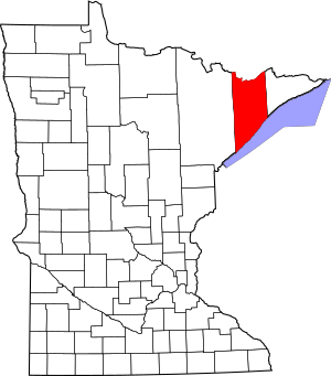
Location within the U.S. state of Minnesota
|
|
 Minnesota's location within the U.S. |
|
| Country | |
| State | |
| Founded | March 1, 1856 |
| Named for | Lake Superior |
| Seat | Two Harbors |
| Largest city | Two Harbors |
| Area | |
| • Total | 2,991 sq mi (7,750 km2) |
| • Land | 2,109 sq mi (5,460 km2) |
| • Water | 881 sq mi (2,280 km2) 29%% |
| Population
(2020)
|
|
| • Total | 10,905 |
| • Estimate
(2023)
|
10,855 |
| • Density | 3.6459/sq mi (1.40770/km2) |
| Time zone | UTC−6 (Central) |
| • Summer (DST) | UTC−5 (CDT) |
| Congressional district | 8th |
Lake County is a county in the state of Minnesota, USA. It's known for its beautiful natural areas and rich history. As of the 2020 census, about 10,905 people lived here. The main town and county seat is Two Harbors. The county is named after the huge Lake Superior, which forms its southern border.
Contents
History of Lake County
Before Europeans arrived, Native American groups lived in this area for a very long time. When Europeans first came, the main Native American groups were the Dakota and Ojibwe. These groups got their food by hunting, fishing, and gathering plants. Wild rice was especially important to them.
The first Europeans to explore the area were the French in the late 1600s. After them came trappers, fur traders, missionaries, and explorers.
How Lake County Was Formed
The Wisconsin Territory was set up in 1836. After Wisconsin became a state, the Minnesota Territory was created in 1849. The new government in Minnesota created nine counties that year. One of these, Itasca, was later split.
On March 1, 1856, the area officially became Lake County. Its first county seat was Beaver Bay. In 1874, the eastern part of Lake County was separated to create Cook County.
Discovering Iron Ore
In 1868, iron ore was found in the Vermilion Range. A railroad was built to the Lake Superior shore. A new town quickly grew at the end of the railroad line. This town was Two Harbors, which became a village in 1888. That same year, people voted to move the county seat from Beaver Bay to Two Harbors.
Growth and New Businesses
Commercial fishing on Lake Superior became important in the late 1880s. Many Swedish and Norwegian immigrants came to the North Shore to fish. In 1890, the Merritt brothers found the Mesabi Range, another big iron ore area.
The Two Harbors Lighthouse was built in 1892. Ten years later, five businessmen in Two Harbors started a new mining company. They called it 3M. Today, 3M is a huge company with many employees worldwide. It makes over 50,000 different products, including many adhesive household items. Its main office is now in Saint Paul.
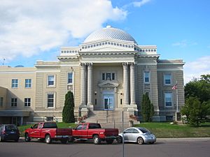
In 1906, the current Court House was built. In 1907, one of the first steel ore docks in the country was built in Two Harbors. In the 1950s, there was another boom in iron ore mining. This was thanks to a new process called taconite beneficiation. This process could turn low-quality iron ore into a useful product.
In 2021, the Greenwood Fire burned over 10,500 acres of the county. It started near Greenwood Lake.
Geography of Lake County
Lake County is located in the northern part of Minnesota. Its northern border touches Ontario, Canada. Its southern border is formed by Lake Superior. However, it's very hard to cross into Canada from Lake County. This is because of the thick forests of the Superior National Forest and the rough land in the northern part of the county.
The county has rolling mountains and hills. It is heavily wooded and has many lakes and ponds. The highest point in the county is Stony Tower Hill, which is 2,301 feet above sea level. Lake County covers about 2,991 square miles. About 2,109 square miles are land, and 881 square miles (29%) are water. It is the fifth-largest county in Minnesota by area.
Lake County is part of the Arrowhead Region in Northeastern Minnesota. This region is shaped like an arrowhead.
Major Highways
Neighboring Counties
- Rainy River District, Ontario - north (Canada)
- Cook County - east
- St. Louis County - west
- Ashland County, Wisconsin - southeast (across Lake Superior)
- Bayfield County, Wisconsin - south (across Lake Superior)
- Douglas County, Wisconsin - south (across Lake Superior)
Protected Natural Areas
- Finland State Forest
- George H. Crosby Manitou State Park
- Gooseberry Falls State Park
- Sand Lake Peatland Scientific and Natural Area
- Split Rock Lighthouse State Park
- Superior National Forest (part)
- Boundary Waters Canoe Area Wilderness (part)
- Tettegouche State Park
Population of Lake County
| Historical population | |||
|---|---|---|---|
| Census | Pop. | %± | |
| 1860 | 248 | — | |
| 1870 | 135 | −45.6% | |
| 1880 | 106 | −21.5% | |
| 1890 | 1,299 | 1,125.5% | |
| 1900 | 4,654 | 258.3% | |
| 1910 | 8,011 | 72.1% | |
| 1920 | 8,251 | 3.0% | |
| 1930 | 7,068 | −14.3% | |
| 1940 | 6,956 | −1.6% | |
| 1950 | 7,781 | 11.9% | |
| 1960 | 13,702 | 76.1% | |
| 1970 | 13,351 | −2.6% | |
| 1980 | 13,043 | −2.3% | |
| 1990 | 10,415 | −20.1% | |
| 2000 | 11,058 | 6.2% | |
| 2010 | 10,866 | −1.7% | |
| 2020 | 10,905 | 0.4% | |
| 2023 (est.) | 10,855 | −0.1% | |
| U.S. Decennial Census 1790-1960 1900-1990 1990-2000 2010-2020 |
|||
2020 Census Information
The 2020 Census showed that Lake County had a population of 10,905 people. Most of the people living in Lake County are White.
| Race | Number | Percentage |
|---|---|---|
| White (Not Hispanic) | 10,281 | 94.3% |
| Black or African American (Not Hispanic) | 11 | 0.1% |
| Native American (Not Hispanic) | 50 | 0.5% |
| Asian (Not Hispanic) | 55 | 0.5% |
| Pacific Islander (Not Hispanic) | 0 | 0% |
| Other/Mixed (Not Hispanic) | 395 | 3.62% |
| Hispanic or Latino | 113 | 1.03% |
Communities in Lake County
Cities
- Beaver Bay
- Silver Bay
- Two Harbors (This is the county seat, where the main government offices are)
Census-Designated Place
Unincorporated Communities
These are smaller communities that are not officially organized as cities or towns.
- Alger
- Castle Danger
- Cramer
- East Beaver Bay
- Highland (also known as Marcy)
- Illgen City
- Isabella
- Knife River
- Larsmont
- Lax Lake
- Little Marais
- McNair
- Murphy City
- Sawbill Landing
- Section Thirty
- Silver Creek
- Stewart
- Toimi
- Waldo
- Wales
Ghost Towns
These are places where towns once existed but are now abandoned.
- Avon
- Avoy
- Beaver
- Britton
- Buell
- Case
- Clark
- Crystal
- Darby Junction
- Drummond
- Eclfo
- Emetta
- Fernburg Tower
- Forest Center
- Freedom
- Green
- Greenwood Junction
- Howlett
- Jordan
- Kent
- London
- Malmota (Marmata)
- Maple
- Marble Lake
- Moose
- Morris
- Murfin
- Nigadoo
- Norshore Junction
- North Branch
- Riblet
- Scott Junction
- Silver
- Splitrock
- Stafford
- Summit
- Swift
- Thomas
- Wanless
- Westover
- Whyte
- Wolf
- York
Townships
These are smaller local government areas within the county.
- Beaver Bay Township
- Crystal Bay Township
- Fall Lake Township
- Silver Creek Township
- Stony River Township
Unorganized Territories
These are areas that do not have their own local government.
See also
 In Spanish: Condado de Lake (Minnesota) para niños
 | Jessica Watkins |
 | Robert Henry Lawrence Jr. |
 | Mae Jemison |
 | Sian Proctor |
 | Guion Bluford |

