Douglas County, Wisconsin facts for kids
Quick facts for kids
Douglas County
|
|
|---|---|

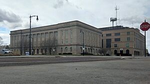
Douglas County Courthouse in Superior in 2023.
|
|

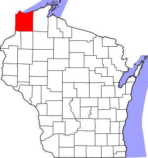
Location within the U.S. state of Wisconsin
|
|
 Wisconsin's location within the U.S. |
|
| Country | |
| State | |
| Founded | February 8, 1854 |
| Named for | Stephen A. Douglas |
| Seat | Superior |
| Largest city | Superior |
| Area | |
| • Total | 1,480 sq mi (3,800 km2) |
| • Land | 1,304 sq mi (3,380 km2) |
| • Water | 176 sq mi (460 km2) 12% |
| Population
(2020)
|
|
| • Total | 44,295 |
| • Estimate
(2023)
|
44,264 |
| • Density | 29.93/sq mi (11.56/km2) |
| Time zone | UTC−6 (Central) |
| • Summer (DST) | UTC−5 (CDT) |
| Congressional district | 7th |
Douglas County is a county in the northwest part of Wisconsin, a state in the United States. It is located right in the corner of the state! In 2020, about 44,295 people lived here. The main city and county seat is Superior. Douglas County is part of a bigger area called the Metropolitan Statistical Area, which includes Duluth, Minnesota.
Contents
History of Douglas County
Douglas County was created on February 8, 1854. It was named after Stephen A. Douglas, who was a famous Senator from Illinois. The City of Superior was chosen right away to be the county seat, which is like the main administrative city for the county.
Geography of Douglas County
Douglas County covers a total area of about 1,480 square miles. Most of this area, about 1,304 square miles, is land. The rest, about 176 square miles (or 12%), is water.
A part of the Fond du Lac Indian Reservation is located within Douglas County.
Neighboring Counties
Douglas County shares borders with several other counties:
- Bayfield County – to the east
- Sawyer County – to the southeast
- Washburn County – to the south
- Burnett County – to the southwest
- Pine County, Minnesota – to the southwest
- Carlton County, Minnesota – to the west
- Saint Louis County, Minnesota – to the northwest
- Lake County, Minnesota - to the northeast
Main Roads
Here are some of the major highways that run through Douglas County:
|
Railroads
Several railroad companies operate in Douglas County:
Bus Services
You can find bus services here from:
- Duluth Transit Authority
- Indian Trails
Airports
The county is served by two airports:
- Solon Springs Municipal Airport (KOLG)
- Richard I. Bong Airport (KSUW)
Protected Areas
A part of the Saint Croix National Scenic Riverway is located in Douglas County. This is a special area protected for its natural beauty.
Population Information
| Historical population | |||
|---|---|---|---|
| Census | Pop. | %± | |
| 1860 | 812 | — | |
| 1870 | 1,122 | 38.2% | |
| 1880 | 655 | −41.6% | |
| 1890 | 13,468 | 1,956.2% | |
| 1900 | 36,335 | 169.8% | |
| 1910 | 47,422 | 30.5% | |
| 1920 | 49,771 | 5.0% | |
| 1930 | 46,583 | −6.4% | |
| 1940 | 47,119 | 1.2% | |
| 1950 | 46,715 | −0.9% | |
| 1960 | 45,008 | −3.7% | |
| 1970 | 44,657 | −0.8% | |
| 1980 | 44,421 | −0.5% | |
| 1990 | 41,758 | −6.0% | |
| 2000 | 43,287 | 3.7% | |
| 2010 | 44,159 | 2.0% | |
| 2020 | 44,295 | 0.3% | |
| U.S. Decennial Census 1790–1960 1900–1990 1990–2000 2010–2020 2020 census |
|||
2020 Census Details
According to the census of 2020, Douglas County had a population of 44,295 people. The average number of people per square mile was about 34.0. There were also 22,906 housing units.
Most of the people in the county, about 89.7%, identified as White. Other groups included 1.8% Native American, 1.3% Black or African American, and 0.6% Asian. About 5.9% of people identified with two or more races. About 1.7% of the population was of Hispanic or Latino background.
2010 Census Details
In the 2010 United States Census, there were 44,159 people living in Douglas County. About 93.2% of them were White. Other groups included 2.0% Native American, 1.1% Black or African American, and 0.9% Asian. About 2.7% of people identified with two or more races. About 1.1% of the population was of Hispanic or Latino background.
Many people in Douglas County have roots from different countries. In 2010, some of the largest ancestry groups included German (20.7%), Norwegian (11.2%), Swedish (9.7%), Irish (7.8%), Finnish (6.4%), and Polish (6.1%).
Communities in Douglas County
Douglas County has different types of communities, from cities to small villages and towns.
City
- Superior (This is the county seat!)
Villages
Towns
Census-Designated Places
These are areas that are like towns but are not officially incorporated as one:
Unincorporated Communities
These are smaller communities that are not officially part of a city or village:
- Ambridge
- Amnicon Falls
- Anton
- Beebe
- Bellwood
- Bennett
- Black River
- Blueberry
- Borea
- Boylston
- Boylston Junction
- Carnegie
- Chaffey
- Cloverland
- Cozy Corner
- Cutter
- Dairyland
- Dedham
- Dewey
- Dobie
- Four Corners
- Foxboro
- Hawthorne
- Hillcrest
- Hines
- Maple
- Middle River
- Moose Junction
- Parkland
- Patzau
- Peyton
- Pokegama
- Riverview
- Rockmont
- Saunders
- Sauntry
- South Itasca
- South Range
- Sunnyside
- Waino
- Wascott
- Wentworth
- Winneboujou
Ghost Towns
These are places that used to be communities but are now abandoned or no longer exist:
- Merriam
- Millcrest
- Morrison (Allouez) (This area was later added to the City of Superior)
- New Bristol (Martinson)
- Nutt
- Pokegama Junction
- Steele
- Troy
- Walbridge
- Way
- Wiehe
See also
 In Spanish: Condado de Douglas (Wisconsin) para niños
 | Mary Eliza Mahoney |
 | Susie King Taylor |
 | Ida Gray |
 | Eliza Ann Grier |

