Sawyer County, Wisconsin facts for kids
Quick facts for kids
Sawyer County
|
|
|---|---|

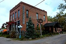
North Wisconsin Lumber Company Office in Hayward, Wisconsin
|
|

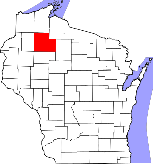
Location within the U.S. state of Wisconsin
|
|
 Wisconsin's location within the U.S. |
|
| Country | |
| State | |
| Founded | 1885 |
| Named for | Philetus Sawyer |
| Seat | Hayward |
| Largest city | Hayward |
| Area | |
| • Total | 1,350 sq mi (3,500 km2) |
| • Land | 1,257 sq mi (3,260 km2) |
| • Water | 93 sq mi (240 km2) 6.9% |
| Population
(2020)
|
|
| • Total | 18,074 |
| • Estimate
(2023)
|
18,552 |
| • Density | 14.4/sq mi (5.6/km2) |
| Time zone | UTC−6 (Central) |
| • Summer (DST) | UTC−5 (CDT) |
| Congressional district | 7th |
Sawyer County is a place in Wisconsin, a state in the United States. It's called a county. In 2020, about 18,074 people lived there. The main town, or county seat, is Hayward. Part of the county is also home to the Lac Courte Oreilles Band of Lake Superior Chippewa Indians reservation.
Contents
History of Sawyer County
The land that is now Sawyer County was once a disputed area. In the 1700s, two groups of Native American people, the Dakota and the Ojibwe, both wanted control of this land.
Early Battles and Treaties
Stories passed down through generations tell us that the Ojibwe people won a big battle against the Dakota in the 1790s. This battle happened on the Upper Chippewa River. By the year 1800, a village of Ojibwe people was already living near Lac Courte Oreilles. They allowed a fur trader named Michel Cadotte to set up a trading post there. This was a place where people could trade animal furs.
Later, the United States gained control of this area from the Ojibwe Nation. This happened through a special agreement called the 1837 Treaty of St. Peters. However, the Ojibwe people kept their right to hunt and fish on the land. In 1854, the Ojibwe successfully worked out another agreement, the 1854 Treaty of La Pointe. This treaty created the permanent Lac Courte Oreilles Indian Reservation.
How Sawyer County Got Its Name
Sawyer County is named after Philetus Sawyer. He was a man from New England who served in the U.S. House of Representatives and the U.S. Senate for Wisconsin in the 1800s.
Logging, which is cutting down trees for wood, started in the late 1850s. Many loggers came from states like New York, New Hampshire, Vermont, and Maine. These people were often called "Yankees." They were descendants of English Puritans who had settled in New England in the 1600s. Many of them belonged to the Congregational Church.
Sawyer County was officially created in 1883 and started operating in 1885. In the 1890s, many new people moved to the county. They came from different countries such as Germany, Norway, Poland, Ireland, and Sweden.
Geography and Natural Features
Sawyer County covers a total area of about 1,350 square miles. About 93 square miles of this area is covered by water, which is about 6.9% of the total. This makes it the fifth-largest county in Wisconsin based on its land area.
Main Roads and Transportation
Several important roads pass through Sawyer County:
 U.S. Highway 63
 Highway 27 (Wisconsin)
 Highway 40 (Wisconsin)
 Highway 48 (Wisconsin)
 Highway 70 (Wisconsin)
 Highway 77 (Wisconsin)
Sawyer County Highway B is a very busy road. In 2008, about 5,900 vehicles used it every day.
Railroads and Airports
Trains also travel through Sawyer County on these lines:
The Sawyer County Airport (KHYR) helps people travel by air. It serves the county and nearby towns.
Neighboring Counties
Sawyer County shares borders with these other counties:
- Bayfield County - to the north
- Ashland County - to the northeast
- Price County - to the east
- Rusk County - to the south
- Barron County - to the southwest
- Washburn County - to the west
- Douglas County - to the northwest
Protected Natural Areas
Parts of two important natural areas are found in Sawyer County:
Population and People
| Historical population | |||
|---|---|---|---|
| Census | Pop. | %± | |
| 1890 | 1,977 | — | |
| 1900 | 3,593 | 81.7% | |
| 1910 | 6,227 | 73.3% | |
| 1920 | 8,243 | 32.4% | |
| 1930 | 8,878 | 7.7% | |
| 1940 | 11,540 | 30.0% | |
| 1950 | 10,323 | −10.5% | |
| 1960 | 9,475 | −8.2% | |
| 1970 | 9,670 | 2.1% | |
| 1980 | 12,843 | 32.8% | |
| 1990 | 14,181 | 10.4% | |
| 2000 | 16,196 | 14.2% | |
| 2010 | 16,557 | 2.2% | |
| 2020 | 18,074 | 9.2% | |
| U.S. Decennial Census 1790–1960 1900–1990 1990–2000 2010 2020 |
|||
2020 Census Information
In 2020, the population of Sawyer County was 18,074 people. This means there were about 14.4 people living in each square mile. There were also 15,966 homes, with about 12.7 homes per square mile.
When looking at the different groups of people in the county:
- About 77.0% were White.
- About 16.3% were Native American.
- About 0.6% were African American.
- About 0.3% were Asian.
- About 0.6% were from other racial groups.
- About 5.2% were from two or more racial groups.
About 2.0% of the population identified as Hispanic or Latino.
Communities in Sawyer County
Sawyer County has different types of communities, from cities to small villages and towns.
City
- Hayward (This is the county seat, the main town for county government.)
Villages
Towns
Census-Designated Places
These are areas that are like towns but are not officially incorporated as cities or villages.
- Chief Lake
- Little Round Lake
- New Post
- Reserve
- Stone Lake (partially in Sawyer County)
Unincorporated Communities
These are smaller communities that are not officially part of a city, village, or town.
See also
 In Spanish: Condado de Sawyer para niños
 | Shirley Ann Jackson |
 | Garett Morgan |
 | J. Ernest Wilkins Jr. |
 | Elijah McCoy |


