Price County, Wisconsin facts for kids
Quick facts for kids
Price County
|
|
|---|---|

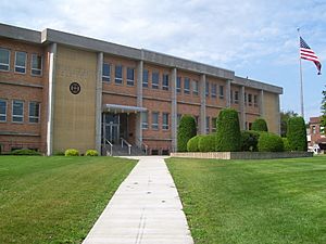
Price County courthouse
|
|

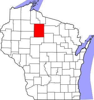
Location within the U.S. state of Wisconsin
|
|
 Wisconsin's location within the U.S. |
|
| Country | |
| State | |
| Founded | 1882 |
| Named for | William T. Price |
| Seat | Phillips |
| Largest city | Park Falls |
| Area | |
| • Total | 1,278 sq mi (3,310 km2) |
| • Land | 1,254 sq mi (3,250 km2) |
| • Water | 24 sq mi (60 km2) 1.9%% |
| Population
(2020)
|
|
| • Total | 14,054 |
| • Estimate
(2023)
|
14,102 |
| • Density | 11.2/sq mi (4.3/km2) |
| Time zone | UTC−6 (Central) |
| • Summer (DST) | UTC−5 (CDT) |
| Congressional district | 7th |
Price County is a county in the state of Wisconsin, USA. A county is like a smaller region within a state. In 2020, about 14,054 people lived there. The main town, or county seat, where the government offices are, is Phillips.
Contents
History of Price County
Price County was officially created on March 3, 1879. This happened when the Governor of Wisconsin, William E. Smith, signed a special law. The county then started to organize itself in 1882.
The county is named after William T. Price (1824–1886). He was an important person who led the Wisconsin Senate. He was also one of the first loggers in the area, meaning he worked with cutting down trees for wood. Later, he was elected to the U.S. Congress. Price County was formed using parts of Chippewa and Lincoln counties.
The first white settler in what is now Price County was Major Isaac Stone. He arrived in 1860 near the Spirit River to work in the lumber industry. Even today, Price County is a big producer of raw timber, which means it still provides a lot of wood from trees.
Geography and Nature
According to the U.S. Census Bureau, Price County covers a total area of 1,278 square miles. Out of this, 1,254 square miles is land, and 24 square miles (about 1.9%) is water.
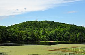
The highest natural point in all of Wisconsin is Timms Hill. It stands at 1,951 feet (about 595 meters) tall and is located right here in Price County.
Neighboring Counties
Price County shares its borders with several other counties:
- Ashland to the northwest
- Iron to the northeast
- Lincoln to the southeast
- Oneida to the east
- Rusk to the west
- Sawyer to the west
- Taylor to the south
- Vilas to the northeast
Main Roads and Transportation
Here are the major highways that run through Price County:
 U.S. Highway 8
 Highway 13 (Wisconsin)
 Highway 70 (Wisconsin)
 Highway 86 (Wisconsin)
 Highway 102 (Wisconsin)
 Highway 111 (Wisconsin)
 Highway 182 (Wisconsin)
Railroads
- Watco
Buses
- Bay Area Rural Transit
Airports
- KPBH - Price County Airport
- KPKF - Park Falls Municipal Airport
- 5N2 - Prentice Airport
Protected Natural Areas
- A part of the Chequamegon National Forest is located in Price County.
Population and People
| Historical population | |||
|---|---|---|---|
| Census | Pop. | %± | |
| 1880 | 785 | — | |
| 1890 | 5,258 | 569.8% | |
| 1900 | 9,106 | 73.2% | |
| 1910 | 13,795 | 51.5% | |
| 1920 | 18,517 | 34.2% | |
| 1930 | 17,284 | −6.7% | |
| 1940 | 18,467 | 6.8% | |
| 1950 | 16,344 | −11.5% | |
| 1960 | 14,370 | −12.1% | |
| 1970 | 14,520 | 1.0% | |
| 1980 | 15,788 | 8.7% | |
| 1990 | 15,600 | −1.2% | |
| 2000 | 15,822 | 1.4% | |
| 2010 | 14,159 | −10.5% | |
| 2020 | 14,054 | −0.7% | |
| U.S. Decennial Census 1790–1960 1900–1990 1990–2000 2010 2020 |
|||
2020 Census Information
The census is a count of all the people living in an area. In the 2020 census, Price County had 14,054 people. The population density was about 11.2 people per square mile. This means that, on average, about 11 people live in every square mile of the county.
There were 10,735 homes or housing units. The average density of homes was about 8.6 units per square mile.
When looking at the different groups of people in the county:
- 94.2% were White
- 0.9% were Pacific Islander
- 0.6% were Native American
- 0.5% were Asian
- 0.2% were Black or African American
- 0.5% were from other races
- 3.1% were from two or more races
About 1.3% of the population identified as Hispanic or Latino.
Towns and Villages
Cities
- Park Falls
- Phillips (This is the county seat)
Villages
Towns
- Catawba
- Eisenstein
- Elk
- Emery
- Fifield
- Flambeau
- Georgetown
- Hackett
- Harmony
- Hill
- Kennan
- Knox
- Lake
- Ogema
- Prentice
- Spirit
- Worcester
Census-designated place
Unincorporated communities
These are smaller communities that are not officially cities or villages:
- Cranberry Lake
- Clifford (partially)
- Brantwood
- Dover
- Fifield
- Lugerville
- Pennington
- Spirit
- Worcester
Ghost towns/neighborhoods
These are places that used to be communities but are no longer populated:
- Coolidge
- Kaiser
- Kennedy
- Knox Mills
- Sassen
See also
 In Spanish: Condado de Price para niños
 | William M. Jackson |
 | Juan E. Gilbert |
 | Neil deGrasse Tyson |


