Iron County, Wisconsin facts for kids
Quick facts for kids
Iron County
|
|
|---|---|

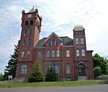
The Old Iron County Courthouse (now the Iron County Historical Museum) in Hurley, Wisconsin.
|
|

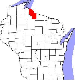
Location within the U.S. state of Wisconsin
|
|
 Wisconsin's location within the U.S. |
|
| Country | |
| State | |
| Founded | 1893 |
| Named for | Iron ore |
| Seat | Hurley |
| Largest city | Hurley |
| Area | |
| • Total | 919 sq mi (2,380 km2) |
| • Land | 758 sq mi (1,960 km2) |
| • Water | 161 sq mi (420 km2) 18% |
| Population
(2020)
|
|
| • Total | 6,137 |
| • Estimate
(2023)
|
6,228 |
| • Density | 8.1/sq mi (3.1/km2) |
| Time zone | UTC−6 (Central) |
| • Summer (DST) | UTC−5 (CDT) |
| Congressional district | 7th |
Iron County is a place in Wisconsin, a state in the USA. In 2020, about 6,137 people lived here. This makes it one of the smaller counties in Wisconsin by population. The main town, or county seat, is Hurley. It got its name because of the valuable iron ore found in the area. Parts of the county are also home to the Bad River and Lac du Flambeau Indian reservations.
Contents
Exploring Iron County's Geography
Iron County covers a total area of about 919 square miles. Most of it, about 758 square miles, is land. The rest, about 161 square miles (18%), is water, like lakes and rivers.
Neighboring Counties
Iron County shares borders with these other counties:
- Vilas County - to the east and southeast
- Price County - to the southwest
- Ashland County - to the west
- Gogebic County, Michigan - to the northeast
Main Roads and Highways
Major highways are important roads that connect different towns and states. Here are the main ones in Iron County:
|
County Roads
These are roads managed by the county itself:
 CTH-A
CTH-A CTH-B
CTH-B CTH-C
CTH-C CTH-CC
 CTH-D
CTH-D CTH-FF
 CTH-G
CTH-G CTH-H
CTH-H CTH-J
CTH-J
Railroads and Airport
- Watco is a company that operates railroads in the area.
- The Gogebic-Iron County Airport (KIWD) offers flights for people traveling by air.
People of Iron County: Demographics
| Historical population | |||
|---|---|---|---|
| Census | Pop. | %± | |
| 1900 | 6,616 | — | |
| 1910 | 8,306 | 25.5% | |
| 1920 | 10,261 | 23.5% | |
| 1930 | 9,933 | −3.2% | |
| 1940 | 10,049 | 1.2% | |
| 1950 | 8,714 | −13.3% | |
| 1960 | 7,830 | −10.1% | |
| 1970 | 6,533 | −16.6% | |
| 1980 | 6,730 | 3.0% | |
| 1990 | 6,153 | −8.6% | |
| 2000 | 6,861 | 11.5% | |
| 2010 | 5,916 | −13.8% | |
| 2020 | 6,137 | 3.7% | |
| U.S. Decennial Census 1790–1960 1900–1990 1990–2000 2010 2020 |
|||
The population of Iron County has changed over the years. The chart above shows how many people have lived here during different census years.
Population in 2020
In 2020, the total population was 6,137 people. This means there were about 8.1 people living in each square mile. There were also about 5,523 homes, with about 7.3 homes per square mile.
Most people in the county, about 95%, were White. About 1.1% were Native American, and smaller numbers were Black, Asian, or from other backgrounds. About 2.8% of people identified with two or more races. About 1.2% of the population was Hispanic or Latino.
Population in 2010
In 2010, there were 5,916 people living in Iron County. Most people (97.9%) were White. Other groups included Native American (0.6%), Asian (0.3%), and Black or African American (0.1%). About 0.9% of people identified with two or more races. About 0.6% of the population was Hispanic or Latino.
Many people in Iron County have family roots from other countries. In 2010, common backgrounds included German (22.9%), Italian (13.7%), Finnish (12.6%), Polish (8.2%), American (6.6%), and Irish (5.4%).
Towns and Communities in Iron County
Iron County has several different types of communities, from small cities to tiny unincorporated places.
Cities
Towns
These are areas that include rural land and sometimes smaller communities within them.
Census-Designated Places
These are areas that look like towns but are not officially incorporated as cities or villages. The government counts their population for the census.
Unincorporated Communities
These are small groups of homes or businesses that are not part of any city or town government.
Historical Places to Visit
The National Register of Historic Places lists several important historical sites in Iron County. These places are special because of their history, how they were built, or what happened there.
| Site | What makes it special | Year it was added |
|---|---|---|
| Annala Round Barn | Its unique architecture and connection to farming | 1979 |
| Montreal Company Location Historic District | How the community was planned and its history with industry | 1980 |
| Old Iron County Courthouse | Its architecture and role in local government | 1977 |
| Plummer Mine Headframe | Its engineering and connection to the mining industry | 1997 |
| Springstead | Its architecture and history of early settlement | 1997 |
See also
 In Spanish: Condado de Iron (Wisconsin) para niños
 | Georgia Louise Harris Brown |
 | Julian Abele |
 | Norma Merrick Sklarek |
 | William Sidney Pittman |


